Maps of Switzerland

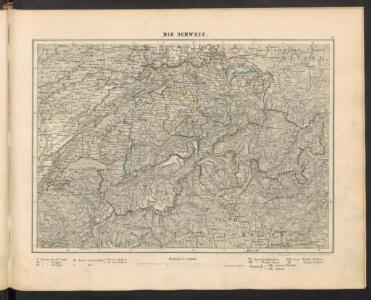
Die Schweiz
[Allgemeiner Atlas über alle Theile der Erde in 29 Blättern] Ziegler, Jakob Melchior Top. Anstalt v. J. Wurster u. Comp.
[Centralalpen und Jura]
Hypsometrischer Atlas Ziegler, Jakob Melchior Topogr. Anstalt v. J. Wurster u. Comp.
Schulkarte der Schweiz
1 : 1200000 Topographische Anstalt von Wurster, Randegger & Cie. (Winterthur) Verlag v. J. Wurster & Cie.
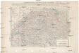
Hypsometrische Karte der Schweiz
1 : 380000 Ziegler, Jakob Melchior Joh. Wurster u. Comp.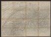
Karte der Schweiz
1 : 380000 Ziegler, Jakob Melchior Huber & Comp.
Novissima foederatorum Helvetiorum tabula
1 Karte : Kupferdruck ; 14 x 18 cm Weigel s.n.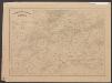
Geologische Übersichtskarte der Schweiz
1 : 760000 Escher von der Linth, Arnold ; Studer, Bernhard Verlag d. topogr. Anstalt v. J. Wurster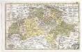
Die Schweitz oder Helvetien
1 Karte : Kupferdruck ; 15 x 25 cm Keller Heinrich Keller
Dritte Karte der Schweiz
1 : 380000 1 Karte J.M. Ziegler J. Wurster & Co., Winterthur
Neue Karte der Schweiz
1 : 380000 Švýcarsko Ziegler, Jakob Melchior J. Wurster u. Comp.
Neue Karte der Schweiz
1 : 380000 1 Karte von J.M. Ziegler Topogr. Anstalt v. J. Wurster u. Comp., Winterthur
Neue Karte der Schweiz
1 : 380000 1 Karte von J.M. Ziegler Wurstser, Winterthur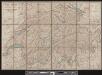
Karte der Schweiz
1 : 400000 1 Karte bearbeitet nach Dufour = Carte de la Suisse / d'après la carte Dufour par R. Leuzinger Verlag der J. Dalp'schen Buchhandlung, Berne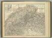
Switzerland and the Alps of Savoy & Piedmont.
1 : 605000 Johnston, Alexander Keith
Carte géologique de la Suisse
1 : 380000 1 Karte in 4 Teilen auf 4 Blättern de B. Studer et A. Escher von der Linth Wurster, Randegger & Co., Winterthur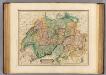
Switzerland.
1 : 760000 Lizars, Daniel
Dritte Karte der Schweiz
1 : 380000 1 Karte J.M. Ziegler J. Wurster & Co., Winterthur
Dritte Karte der Schweiz
1 : 380000 1 Karte J.M. Ziegler ; publ. par J. Wurster J. Wurster & Co., Winterthur
Carte routière de la Suisse
1 : 450000 1 Karte augmentée et corrigée après la dernière de Keller Giocondo Regazzoni, Milano
Kurskarte der schweizerischen Postverwaltung
Mit Abfahrts- und Ankunftstunden der Postkurse.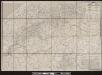
Karte der Posten, Telegraphen und Eisenbahnen der Schweizerischen Eidgenossenschaft
1 : 300000 1 Karte offizielle Ausgabe durch das Postdepartement nach dem eidgenössischen Atlasse = Carte des postes, des télégraphes et des chemins de fer de la Confédération Suisse / édititon officielle publiée par le Département des Postes d'après l'atlas fédéral Wurster, Winterthur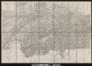
Officielle Eisenbahn-Karte der Schweiz
1 : 250000 1 Karte gest. v. H. Müllhaupt Eidg. Stabsbureau, [Bern]
Carte de la république des Suisses, où sont distingués les 13 cantons et leurs alliés, les sujets de ces cantons et ceux de leurs alliés
1 Karte par Robert de Vaugondy ; E. Haussard sculsp. [i.e. sculps.] [Robert de Vaugondy], [Paris]
Hypsometrische Karte der Schweiz
1 : 1200000 Wurster u. Comp.
Keller's lithographirte Reisekarte der Schweiz
1 : 500000 1 Karte [gez. v. H. Keller] ; G. Frauenfelder lith. [Keller], [Zürich]
Keller's lithographirte Reisekarte der Schweiz
1 : 500000 1 Karte gez. v. H. Keller ; G. Frauenfelder lith. [Keller], [Zürich]
[Kaart], uit: Suisse = Schweiz = Svizzera
1 : 600000 titelvariant: Schweiz; Svizzera; Schulkarte der Schweiz; Annotatie: Titel op omslag : Schulkarte der Schweiz; Annotatie geografische gegevens: Bijkrt.: Politische Übersicht = Carte politique = Carta politica. - Schaal 1:2.750.000 Wintherthur : Kartographia
Karte der Schweiz
1 : 450000 1 Karte nach den neuesten Materialien entworfen und gezeichnet von Rudolf Gross ; gravirt: Terrain v. J. Graf, Schrift v. C. Spengler Ch. Beyel, Frauenfeld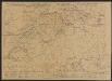
Carte des chemins de fer de la Suisse
1 : 300000 Müllhaupt, Fritz ; Ammann, J. Müllhaupt, Geogr. Kunst-Institut