Maps of Bulgaria

[Die Europäische Türkei]
Hand-Atlas über alle Theile der Erde nach dem neuesten Zustande und über das Weltgebäude Stieler, Adolf bei Justus Perthes
Die Euopaeische Türkei von der Gränze Griechenlands bis zu den Mündungen der Donau
Hand-Atlas über alle Theile der Erde nach dem neuesten Zustande und über das Weltgebäude Stieler, Adolf bei Justus Perthes

Die europaeische Türkei von der Gränze Griechenlands bis zu den Mündungen der Donau
1 : 2500000 Evropa jihovýchodní Stülpnagel, Friedrich von Justus Perthes
Die europaeische Türkei von der Gränze Griechenlands bis zu den Mündungen der Donau
osmanská říše Stülpnagel, Friedrich von Hanemann, August Justus Perthes
Die europaeische Türkei von der Gränze Griechenlands bis zu den Mündungen der Donau
osmanská říše Stülpnagel, Friedrich von Hanemann, August Justus Perthes
Das Erste Bulgarische Reich (680-1018 n. Chr.)
Bulgarien
Südosteuropa 1878
Südosteuropa Berliner Kongress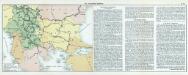
Nr. 18. Die Eroberung Serbiens
Serbien Weltkrieg <1914-1918>, Eroberung
Das Zweite Bulgarische Reich (1087-1256 n. Chr.)
Bulgarien
Europae tabula IX
1 : 5600000 1 Karte : Kupferdruck ; 19 x 25 cm Ptolemaeus, Claudius [Vincenzo Valgrisi]
Balkan
Balkanhalbinsel
Règions occupèes par les belligèrants fin avril 1913
Südosteuropa Balkankrieg <1912-1913> Besetzte Gebiete
Südosteuropa 1919-1941/44
Südosteuropa Grenzen
Albanie Supre., Roumilie, Servie, Bulgarie, Valachie
Nouvel atlas physique politique et historique de l'Empire ottoman et des états limitrophes en Europe, en Asie et en Afrique, en quarante feuilles Hellert, J.J. Bellizard, Dufour et Cie
Europ. Turkey.
1 : 3100000 Radefeld, Carl Christian Franz, 1788-1874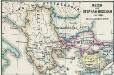
Reich des Stephan Duschan
1 : 10000000 Serbien Stefan Dušan, Srbija, Car
Europäische Türkey
Grosser Hand-Atlas über alle Theile der Erde in 170 Karten Meyer, J. Verlag des Bibliographischen Instituts
Die Europaische Turkei.
1 : 2500000 Petermann, A.
Die Europäische Türkei
Hand-Atlas über alle Theile der Erde und über das Weltgebäude Stieler, Adolf Justus Perthes
Paasche's Frontenkarte, Nr.6. Der Krieg gegen Russland

Die Europäische Türkei
Handatlas über alle Theile der Erde und über das Weltgebäude Stieler, Adolf Justus Perthes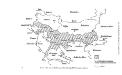
Die von den Balkanstaaten bis Ende April 1913 besetzten Gebiete
Südosteuropa, Osmanisches Reich, Balkankriege Häusler, Ines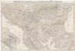
General-Karte von der europäischen Türkey
1 : 1000000 Bospor (Turecko : průliv) Kiepert, Heinrich Kratz, W. u. C. Dietrich Reimer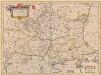
Walachia Servia, Bulgaria, Romania [Karte], in: Novus atlas absolutissimus, Bd. 2, S. 305.
1 Karte aus Atlas Janssonius Offizin
Walachia Serbia, Bulgaria, Romania. [Karte], in: Theatrum orbis terrarum, sive, Atlas novus, Bd. 1, S. 111.
1 Karte aus Atlas Blaeu, Joan Blaeu, Willem Janszoon
Grenzen vor dem Kriege
Südosteuropa Osmanisches Reich Grenze
Carte de la Turquie d'Europe
Balkánský poloostrov Boué, A. Arthus-Bertrand chez Arthus-Bertrand
Der Südost-Balkan 1919-1941
Südosteuropa
![[Die Europäische Türkei]](https://images-2.georeferencer.com/images/iiif/536098787857/full/,300/0/native.jpg)

