Maps of Castilla y León

[Spanien und Portugal in 4 Blättern]
Hand-Atlas über alle Theile der Erde nach dem neuesten Zustande und über das Weltgebäude Stieler, Adolf bei Justus Perthes
[Spanien und Portugal in 4 Blättern]
Hand-Atlas über alle Theile der Erde und über das Weltgebäude Stieler, Adolf Justus Perthes
Spain = España : I
1 mapa. J. & C. Walker sculp. The Society for the Diffusion of Useful Knowledge; Charles Knight & Co
Partie septentrionale de la couronne de Castille
1 Karte : Kupferdruck ; 46 x 57 cm Robert de Vaugondy; Santini; Remondini chez Mr. Remondini
Partie septentrionale de la couronne de Castille
1 Karte : Kupferdruck ; 47 x 58 cm Robert de Vaugondy G. et D. Robert de Vaugondy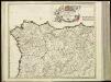
[8][8] Regnorum Castellae Veteris, Legionis, et Gallaeciae..., uit: Atlas sive Descriptio terrarum orbis
Annotatie: Gedigitaliseerde versie. Amsterdam. Heiloo : Picturae (vervaardiger), 2015. tiff-bestand. Gedigitaliseerd: 07-01-2015; Origineel: Universiteitsbibliotheek Vrije Universiteit (XL.05127.-) ; Netherlands; Titelpagina ontbreekt Wit, Frederik de Amsterdam : Frederick de Wit
[Spanien und Portugal in 4 Blättern]
Hand-Atlas über alle Theile der Erde nach dem neuesten Zustande und über das Weltgebäude Stieler, Adolf bei Justus Perthes
Feuille 29 (A V), uit: Carte géologique internationale de l'Europe : la carte, votée au congrès géologique international de Bologne en 1881, est exécutée conformément aux décisions d'une commission internationale, avec le concours des gouvernements, sous le dir. de M.M. Beyrich et Hauchecorne
Annotatie: Blad 48 gamme des couleurs; blad 49: bladwijzer en titelblad Heinrich Ernst Beyrich 1815-1896; Wi. Hauchecorne Berlin : Reimer / (Berlin: Institut lithographique)
Carte réduite des costes d'Espagne et de Portugal
1 Karte : Kupferdruck ; 87 x 54 cm Bellin s.n.
Regnorum Castellæ veteris, Legionis, et Gallæciæ principatuumq[ue] Biscaiæ, et Asturiarum accuratissima descriptio
1 Karte : Kupferdruck ; 48 x 56 cm Wit ex officina J. Cóvens et C. Mortier
Regnorum Castellæ veteris, Legionis, et Gallæciæ principatuumq[ue] Biscaiæ, et Asturiarum accuratissima descriptio
1 Karte : Kupferdruck ; 48 x 56 cm Wit ex officina Frederici de Wit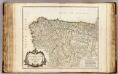
Castille septentrionale.
1 : 1250000 Robert de Vaugondy, Gilles, 1688-1766
[132][135] Hispaniae, et Portugalliae Maritimi tractus, uit: Atlas sive Descriptio terrarum orbis
Annotatie: Gedigitaliseerde versie. Amsterdam. Heiloo : Picturae (vervaardiger), 2015. tiff-bestand. Gedigitaliseerd: 07-01-2015; Origineel: Universiteitsbibliotheek Vrije Universiteit (XL.05127.-) ; Netherlands; Titelpagina ontbreekt Wit, Frederik de Amsterdam : Frederick de Wit
Les estats de la couronne de Castille, dans les parties plus septentrionales de l'Espagne
1 Karte : Kupferdruck ; 40 x 53 cm Sanson; Somer chez l'auteur
Carte nouvelle et curieuse du royaume d'Espagne / C. Inselin, 1
1 Blatt : Inselin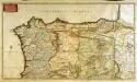
Regnorum Castellæ veteris Legionis et Gallæciæ principatuumq[ue] Biscaiæ et Asturiarum accuratissima descriptio
1 Karte auf 2 Blatt : Kupferdruck ; 46 x 81 cm Visscher Nicolaes Visscher
Hispaniæ, et Portugalliæ maritimi tractus, à S. Andero, ad Malagam
1 Karte : Kupferdruck ; 47 x 56 cm Renard Louis Renard
A new Military Map of Spain and Portugal compiled from The Nautical Surveys of Don Vincent Tofiño, the new Provincial maps of Don Tomas Lopez, the large map of the Ptrenees by Roussill, and various original documents
1 Mapa en 4 seccions dins d'un estoig. John Stockdale J. Stockdale
Espagne et Portugal. Flle. N.O.
1 : 1250000 Vivien St Martin, L.
Neueste Generalkarte von Portugal und Spanien, 1
1 Blatt : 69 x 51 cm Schrämbl
Partie septentrionale du royaume de Portugal, les royaumes de Leon et de Galice, les Asturies, partie des deux Castilles [et]c
1 Karte : Kupferdruck ; 44 x 56 cm Jaillot; Dezauche chez Dezauche géog. rue des Noyers près celle des Anglois
Novissima et accuratissima tabula, quâ Gallæciæ et Legionis regna, Asturiarum principa.tus Portugalliæ tractus septentrionalis
1 Karte : Kupferdruck ; 46 x 58 cm Ottens; Ottens R. et J. Ottens
Spanien NO.
1 : 1800000 Berghaus, Heinrich; Flemming, Carl; Sohr, Karl; Theinert, A.
Corona Portugalliae cum ei affinibus Regnis Hispanicis : Don Pedro generosissimo regi Portugalliae dedicatur
1 : 1100000 per Jacobum Robyn Amst. Bat. Luggerdus van Anse schulp. Amst. Bat. : per Jacobum Robyn
[Spanien und Portugal in 4 Blättern, Blatt 1]
Handatlas über alle Theile der Erde und über das Weltgebäude Stieler, Adolf Justus Perthes
[Spanien und Portugal, Blatt 1]
Adolf Stieler's Handatlas über alle Theile der Erde und über das Weltgebäude Stieler, Adolf Justus Perthes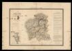
Mapa de Galicia con las nuevas divisiones
1 Mapa. Atlas Nacional de España Dufour, A.H. 0
La Galice, les Asturies, le r. de Léon, la Castille Vieille et la Biscaye
1 : 7660000 Asturie (Španělsko) Bonne, Rigobert André
Theatre de la guerre en Portugal, et dans les Algarves
1 Blatt : 51 x 63 cm Covens et Mortier
![[Spanien und Portugal in 4 Blättern]](https://images-2.georeferencer.com/images/iiif/879653240872/full/,300/0/native.jpg)

