Maps of Durazno

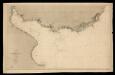
[Süd-Amerika in 6 Blättern, Blatt 6]
Adolf Stieler's Handatlas über alle Theile der Erde und über das Weltgebäude Stieler, Adolf Justus Perthes
[Chart of Maldonado and the Island of Gorriti]
1 : 15840
Situationsplan von Montevideo
Carta del Río de la Plata, según los trabajos más fidedignos nacionales y extranjeros.
1 carta nàutica. Abans 33-1-3 Dirección de Hidrografía (Espanya)
CARTE DE LA RIVIERE DE LA PLATA
1 : 1770000 La Plata (Argentina a Uruguay : oblast) Bellin, Jacques-Nicolas
Afteekening van het incomen van Rio de La Plata met alle desselfs gronden en banken tot voor Boinos Airos
Argentina Gerard van Keulen
Afteekening van Rio de La Plata aen t Zuijd Eijnde van Brasilia na een Spaanse afteekening
Argentina Gerard van Keulen
Partie du Bresil. Amer. Merid. 35.
1 : 1641836 Vandermaelen, Philippe, 1795-1869
Plan topographique de la république orientale de l'Uruguay
1 : 2650000
Amerique Meridionale 4.
1 : 6400000 Brue, Adrien Hubert, 1786-1832
South America (southern sheet).
1 : 8989200 Johnston, Alexander Keith
South America (southern sheet).
1 : 8989200 Johnston, W. & A.K.
United Provinces, Chili, Patagonia.
1 : 18000000 Grigg, John
Buenos Ayres, Chili & Patagonia.
1 : 14000000 Greenleaf, Jeremiah
United Provinces, Chili & Patagonia.
1 : 14000000 Greenleaf, Jeremiah
South America south.
1 : 10500000 Cary, John, ca. 1754-1835
Süd-America in zwei Blättern
Hand-Atlas über alle Theile der Erde nach dem neuesten Zustande und über das Weltgebäude Stieler, Adolf bei Justus Perthes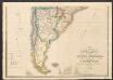
South America [South]
A new general atlas of modern geography, consisting of a complete collection of maps of the four quarters of the globe Wyld, James James Wyld
South America.
1 : 2534400 Burr, David H., 1803-1875
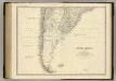
Der Südliche Theil von Süd-America
Hand-Atlas über alle Theile der Erde nach dem neuesten Zustande und über das Weltgebäude Stieler, Adolf bei Justus Perthes
Der südliche Theil von Süd-America enthaltend Bolivia, das südliche Brasilien, Paraguay, La Plata Staaten, Chile und die Südspitze
1 : 7600000 entw. u. gez. vom Pr. L. v. Stülpnagel Hase sc. Gotha : Perthes
South America S.
1 : 8989200 Johnston, Alexander Keith, 1804-1871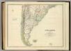
South America (southern sheet).
1 : 8989200 Johnston, Alexander Keith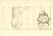
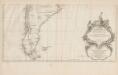
Amerique Meridionale [c]
1 : 6300000 Hoja del inferior del más importante y detallado mapa francés sobre Suramérica de mediados del siglo XVIII, elaborado por Jean Baptiste Bourguignon D’Anville, una de las autoridades cartográficas más trascendentales e influyentes de su tiempo. Esta parte del mapa muestra la región de las pampas y de la Patagonia, al extremo sur de América, en las actuales Chile y Argentina. El mapa enfatiza, con sus espacios en blanco, el carácter desconocido y salvaje de estas regiones, según los europeos. D’Anville registra las tensiones entre españoles e ingleses por las Islas Malvinas o Falkland. De particular interés resulta el cartucho decorativo, en la parte inferior del mapa: allí aparece una escena alegórica del dominio católico del subcontinente. Anville, Jean Baptiste Bourguignon d' (1697-1782) Delahaye, Guillaume-Nicolas (1727-1802)
230-231. South America, South. The World Atlas.
1 : 7500000 USSR (Union of Soviet Socialist Republics).
Sud-America III.
1 : 13000000 Berghaus, Heinrich; Flemming, Carl; Handtke, Friedrich H.; Sohr, Karl
Patagonia. South Orkney. Falkland Islands. South Georgia Island.
1 : 8000000 Colton, G.W.
![[Süd-Amerika in 6 Blättern, Blatt 6]](https://images-2.georeferencer.com/images/iiif/001426361489/full/,300/0/native.jpg)

