Maps of Greece

Grecia antica - Isole del mare Egeo - Macedonia - Tracia
1 : 2400000 Marzolla, Benedetto [Verlag nicht ermittelbar]
Grece ancienne et de la Mer Egee.
1 : 2400000 Brue, Adrien Hubert, 1786-1832
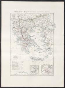
Grece moderne, Archipel, Albanie, Macedoine.
1 : 2400000 Picquet, C.
Turska i Grčka
1 : 5000000 Rumunsko G. Freytag i Berndt
Grece moderne, Archipel, Albanie, Macedoine.
1 : 2400000 Brue, Adrien Hubert, 1786-1832
Geographie des temps heroiques de la Grece; Homere, Hesiode les argonautes.
Vivien de Saint-Martin, M.
Grece Ancienne, Macedoine, Thrace, &a.
1 : 2400000 Picquet, C.
Tabula Europae X. [Karte], in: Claud. Ptolemaeus. Geographia lat. cum mappis [...], S. 281.
1 Karte aus Atlas Münster, Sebastian [und Ptolemaeus, Claudius]
Decima Et Ultima Tabula Europae [Karte], in: Claudii Ptolemei viri Alexandrini mathematice discipline philosophi doctissimi geographie opus [...], S. 178.
1 Karte aus Atlas Waldseemüller, Martin [und Ptolemaeus, Claudius] Übelin, Georg
Greece.
1 : 2851200 Burr, David H., 1803-1875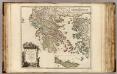
Graecia Vetus.
1 : 1700000 Sanson, Nicolas, 1600-1667
Imperium Latinorum
Lateinisches Kaiserreich
Graeciae et Archipelago divisus in singulares regiones Macedoniae, Albaniae, Epiri, Thessaliae, Achaiae et Moreae, quibus accedunt insulae Candia, Corcyra, Cephalonia, Zacyntho, Stalimine, Metelino, Chius, etc
1 : 1600000 per Gerardum et Leonardum Valk [Amsterdam] : Valk
Composite: Graeciae Antiquae.
1 : 1280000 L'Isle, Guillaume de, 1675-1726
Composite: Graeciae Antiquae tabula nova.
1 : 1280000 L'Isle, Guillaume de, 1675-1726
Bojiště řecko-turecké
1 : 1750000 Turecko Hanf, Norbert Jos. R. Vilímek
Graecia cum terris adjacentibus
Griechenland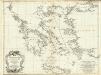
Les Cotes de la Grece et l'Archipel.
1 : 1340000 Anville, Jean Baptiste Bourguignon d, 1697-1782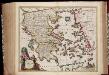
Ellas, seu Graecia universa / auctore J. Laurenbergio
1 : 2150000 titelvariant: Hellas, seu Graecia universa; Annotatie: Origineel is Blad 168 in atlas factice; Annotatie geografische gegevens: Schaalstokken op kaart: 100 Milliaria Italica communia (=8,6 cm), en: 25 Milliaria Germanica communia (=8,6 cm) Nicolaes Jansz. Visscher jr. 1649-1702 [S.l. : N. Visscher excudit]
Grece Ancienne, Macedoine, Thrace.
1 : 2400000 Levasseur, E.
[...] [Hellás], Seu Graecia Universa. [Karte], in: Novus atlas absolutissimus, Bd. 5, S. 277.
1 Karte aus Atlas Janssonius Offizin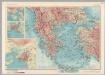
Albania, Greece. Pergamon World Atlas.
1 : 2500000 Polish Army Topography Service
Südliche Balkanstaaten
1 : 5000000 balkánské země Langenscheidtsche Buchdruckerei
Hellas. seu Graecia Universa. [Karte], in: Novus atlas absolutissimus, Bd. 10, S. 36.
1 Karte aus Atlas Janssonius Offizin
Graecia. [Karte], in: Theatrum orbis terrarum, sive, Atlas novus, Bd. 3, S. 282.
1 Karte aus Atlas Blaeu, Joan Blaeu, Willem Janszoon
GRÆCIA
Joh. et Corn. Blaeu exc.
Graecia. [Karte], in: Novus Atlas, das ist, Weltbeschreibung, Bd. 3, S. 332.
1 Karte aus Atlas Blaeu, Joan Blaeu, Willem Janszoon
Isles of Ægean Sea.
from A new sett of maps both of antient and present geography : wherein not only the latitude and longitude of many places are corrected according to the latest observations, but also the most remarkable differences of antient and present geography may be quickly discern'd by a bare inspection or comparing of correspondent maps, which seems to be the most natural and easy method to lead young students (for whose use the work is principally intended) unto a competent knowledge of the geographical science : together with a geographical treatise particularly adapted to the use and design of these maps / by Edward Wells, M.A. and student of Christ-Church, Oxon.
GRAECIAE et ARCHIPELAGI delineatio
Řecko