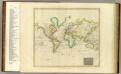
Maps of Asia

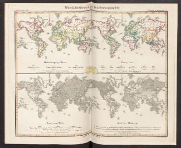
Verschiedenes zur Anthropographie
Zweiter Band, enthaltend in vier Abtheilungen die Vertheilung der Organismen: 5. Pflanzen-Geographie, 6. Thier-Geographie, 7. Anthropographie, 8. Ethnographie Humboldt, Alexander von Verlag von Justus Perthes
MAPPE MONDE ou Description DU GLOBE Terrestre & Aquatique
země světa Jaillot, Alexis-Hubert H. Jaillot
[Erdkarte in Mercator's Projection, Vertheilung der Menschenracen und Verbreitungsgebiet einiger Hauptnährpflanzen]
Volksschul-Atlas über alle Teile der Erde Lange, Henry Druck und Verlag von Georg Westermann
Aevi Veteris, Typus Geographicus. [Karte], in: Theatrum orbis terrarum, S. 447.
1 Karte aus Atlas Ortelius, Abraham Vrients, Jan Baptista
NOVA ET ACCVRATISSIMA TOTIVS TERRARVM ORBIS TABVLA
Auctore IOANNE BLAEV [Amsterdam : Joan Blaeu]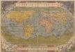
Typus Orbis Terrarum. [Karte], in: Theatrum orbis terrarum, S. 14.
1 Karte aus Atlas Ortelius, Abraham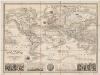
Planisphere : elémentaire et illustré indiquant la description géographique des parties connues de la terre, l'époque des grandes découvertes des navigateurs les colonies Européennes, les principaux parcours des paquebots, l'époque des départs, la durée du trajet, &c[a]
1 : 50000000 Vuillemin, A. (Alexandre), b. 1812 Fatout
Mapa que demuestra el derrotero q[ue] : hizo M. Cook en 1776, 1777, 1778, y 1779 en su tercero y ultimo viaje
1 : 600000 Libreria de Copin Libreria de Copin
Westliche Halbkugel
Hand-Atlas über alle Theile der Erde nach dem neuesten Zustande und über das Weltgebäude Stieler, Adolf bei Justus Perthes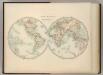
World in Hemispheres.
1 : 72000000 Johnston, W. & A.K.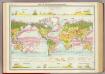
World - vegetation & ocean currents.
1 : 92000000 John Bartholomew and Son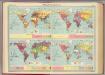
World - population &c.
1 : 153000000 John Bartholomew and Son
World On Mercator's Projection.
1 : 84000000 Fullarton, A. & Co.
Map of The World Illustrating ... Meteorology ... And Limits of Cultivation.
1 : 200000000 Colton, G.W.
Map of The World Illustrating..Land...Co-Tidal Lines...Ocean Currents...River Systems.
1 : 200000000 Colton, G.W.
Map of The World Showing ... The Animal Kingdom ... Commerce And Navigation.
1 : 200000000 Colton, G.W.
Nova Totius Terrarum Orbis Geographica Ac Hydrographica Tabula [Karte], in: Novus Atlas, das ist, Weltbeschreibung, Bd. 1, S. 16.
1 Karte aus Atlas Blaeu, Joan Blaeu, Willem Janszoon
Planiglob zur Übersicht der Verbreitung der Indo-Germanen und Semiten über die gesammte Erdfläche
Zweiter Band, enthaltend in vier Abtheilungen die Vertheilung der Organismen: 5. Pflanzen-Geographie, 6. Thier-Geographie, 7. Anthropographie, 8. Ethnographie Humboldt, Alexander von Verlag von Justus Perthes
Connaissances geographiques.
1 : 65000000 Garnier, F. A., 1803-1863
The World On Mercator's Projection.
1 : 135000000 Tallis, J. & F.
Chart of the World, According to Mercators Projection.
1 : 80000000 Carey, Mathew
A Chart of the World According to Mercators Projection.
1 : 82000000 Carey, Mathew
A Chart of the World According to Mercators Projection.
1 : 82000000 Carey, Mathew
Map of the World Exhibiting all the New Discoveries.
1 : 190000000 Morse, Jedidiah
Allgemeine Welt-Karte in Mercator's Projection, zur Uebersicht der grossen Verkehrs-Linien über Land und Meer und neuerer Reisen um die Erde / von Hermann Berghaus
1 : 48000000 Berghaus, Hermann Gotha : Justus Perthes
Typus Orbis Universalis [Karte], in: Claud. Ptolemaeus. Geographia lat. cum mappis [...], S. 248.
1 Karte aus Atlas Münster, Sebastian [und Ptolemaeus, Claudius]
[Kaart], uit: The official map of the world : showing the four quarters of the globe on the quarter-spherical or orange-peel proj. / originated by L.V. Crocker
1 : 20000000 Annotatie: Met plaatsnamenregister (geeft van een groot aantal plaatsen ook het aantal inwoners) Crocker, Lawton V. Chester, Vt. : The National Survey Co.
Vergleichende Ansicht der vorzüglichsten Gebirge und Flüsse der Erde
země světa Birkenthal, M. bei A. Strauss's sel. Witwe
Atlas über die Entwicklung von Industrie und Handel der Schweiz in dem Zeitraume vom Jahr 1770 bis zum Jahr 1870
1 : 45000000 1 Atlas ([3], VIII Bl.) im Auftrage der schweizerischen Commission für die additionellen Ausstellungen in Wien, bearbeitet von Dr. Hermann Wartmann Wurster Randegger & Co., Winterthur
Welt-Karte, Globular-Proj.
1 : 150000000 Radefeld, Carl Christian Franz, 1788-1874
Planiglob zur Ubersicht der Verbreitung der Indo-Germanen .
1 : 140000000 Berghaus, Heinrich
Welt-Karte, Mercators Proj.
1 : 125000000 Radefeld, Carl Christian Franz, 1788-1874
World on Mercators Projection.
1 : 80000000 Tanner, Henry S.
The World On Mercators Projection.
1 : 80000000 Tanner, Henry S.
World on Mercators Projection.
1 : 80000000 Tanner, Henry S.
World on Mercators Projection.
1 : 80000000 Tanner, Henry S.
World on Mercators Projection.
1 : 80000000 Tanner, Henry S.