Maps of Region Heilbronn-Franken
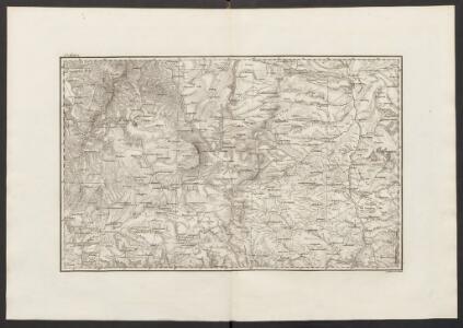
Militair Karte von Süd-Deutschland in 20 Sectionen
1 : 400000 6. Section Coulon, Alois von A. von Coulon
S.R.Imp. Circuli Franconici Geographica Delineatio Francken-Land mit Seinen Gräntzen
Mollova mapová sbírka Endter, Wolfgang Moritz Endter, Wolfgang Moritz
Geographica provinciarum Sueviae descriptio, 2
4 Blätter : Johann Georg Bodenehr
Generalkarte von Zentraleuropa

Karte vom Fürstenthum Anspach oder Onolzbach oder Burggrafthum Unterhalb des Gebürges (Principatus Onoldinus)
1 : 200000 Ansbach (Německo) Schropp, Simon F.G. Baumgartenschen Buchhandulng
Nova et Accuratior Repraesentatio Geographica Sacr. Rom. Imperii Episcopatus Würceburgensis Franciae Orientalis Ducatus cum Omnibus suis Praefecturis, et ditionibus eò Pertinentibus etc.
1 : 360000 Mollova mapová sbírka Seutter, Matthäus Seutter, Matthäus
Würzburg 114, uit: Special-Karte von Mittel-Europa / nach amtlichen Quellen bearbeitet von W. Liebenow
1 : 300000 titelvariant: W. Liebenow's Mittel-Europa; Annotatie: Titel boven de bladen: W. Liebenow's Mittel-Europa Johannes Wilhelm Liebenow 1822-1897 Frankfurt a. M. : Ludwig Ravenstein
Carte topographique d'Allemagne contenant la Franconie sçavoir une partie des evechés de Wurzbourg de Bamberg
1 Karte : Kupferdruck ; 46 x 62 cm Jaeger; Facius se vend chés l'auteur
Tabula Geographica Nova exhibens Partem Infra Montanam Burggraviatus Norimbergensis Sive Principatum Onolsbacensem cum Terris Limitaneis Accurate delineatam
1 : 140000 Mollova mapová sbírka Vetter, Johann Georg Kauffer, Michael
Würzburg 114, uit: [W. Liebenow's Special-Karte von Mittel-Europa]
1 : 300000 titelvariant: W. Liebenow's Mittel-Europa; Annotatie: Titel boven de bladen: W. Liebenow's Mittel-Europa Johannes Wilhelm Liebenow 1822-1897 Hannover : Hermann Oppermann
Tabulae geographicae principatus Brandenburg. Culmb. sive Baruthini
1 : 179600 Bavorsko severní (Německo) Lotter, Tobias Conrad Tob. Conrad Lotter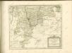

Tabulae Geographicae Principatus Brandenburg: Culmb: sive Baruthini Pars Inferior cum adjacentibus Regionibus exhibita et Sculpta
1 : 150000 Mollova mapová sbírka Seutter, Matthäus Seutter, Matthäus
Tabula Geographica Nova exhibens Partem Infra Montanam Burggraviatus Norimbergensis Sive Principatum Onolsbacensem cum Terris Limitaneis Accurate delineatam
1 : 140000 Mollova mapová sbírka Vetter, Johann Georg Windter, Johann W. Vetter, Johann Georg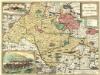
Das Bisthum Wurtzburg in Francken
1 : 280000 Mollova mapová sbírka Seyfried, Johann Heinrich Schollenberger, Johann Jakob Hoffmann, Johann
Comitatus Wertheimici Finitimarumque Regionum Nova Et Exacta Descriptio. [Karte], in: Gerardi Mercatoris et I. Hondii Newer Atlas, oder, Grosses Weltbuch, Bd. 1, S. 221.
1 Karte aus Atlas Mercator, Gerhard und Hondius, Jodocus Jansson, Jan
Comitatus Wertheimici Finitimarumque Regionum Nova Et Exacta Descriptio. [Karte], in: Novus atlas absolutissimus, Bd. 2, S. 180.
1 Karte aus Atlas Janssonius Offizin
Mappa Geographica exhibens Principatvm Brandenbvrgico Onolsbacensem, una cum finitimis Regionibus Terrisque
1 : 260000 Mollova mapová sbírka Cnopf, Matthäus Ferdinand Hauer, Daniel Adam Homann, Johann Baptista - dědici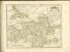

COMITATVS | WERTHEIM | cum adjacentibus
[Amsterdam : Joan Blaeu]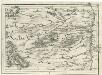
Geographica Provinciarum Sveviae Descriptio =
Mollova mapová sbírka Hurter, Johann Christoph Bodenehr, Gabriel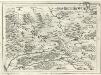
Geographica Provinciarum Sveviae Descriptio =
Mollova mapová sbírka Hurter, Johann Christoph Bodenehr, Johann Georg
152. Würzburg, uit: Topographische Uebersichtskarte des Deutschen Reiches / herausgegeben v. d. Kartogr. Abt. d. Königl. Preuß. Landesaufnahme
1 : 200000 titelvariant: Topogr. Übersichtskarte des Deutschen Reiches; Annotatie: Titel boven bladen ook: Topogr. Übersichtskarte des Deutschen Reiches; Annotatie geografische gegevens: Op elk blad twee maatstokken: 10 Kilometer = 5,5 cm; 1 geogr. Meile = 3,6 cm; Legenda onder op elk blad Königlich Preußische Landesaufnahme. Kartographische Abtheilung [S.l : Königlich Preußische Landesaufnahme, Kartographische Abtheilung]
153. Bamberg, uit: Topographische Uebersichtskarte des Deutschen Reiches / herausgegeben v. d. Kartogr. Abt. d. Königl. Preuß. Landesaufnahme
1 : 200000 titelvariant: Topogr. Übersichtskarte des Deutschen Reiches; Annotatie: Titel boven bladen ook: Topogr. Übersichtskarte des Deutschen Reiches; Annotatie geografische gegevens: Op elk blad twee maatstokken: 10 Kilometer = 5,5 cm; 1 geogr. Meile = 3,6 cm; Legenda onder op elk blad Königlich Preußische Landesaufnahme. Kartographische Abtheilung [S.l : Königlich Preußische Landesaufnahme, Kartographische Abtheilung]

Das Franken-Weinland
1 : 493000 Bavorsko (Německo) Hellrung, Carl Ludwig Baensch, E. Rubach'schen Buchhandlung
Deutsche Strassenprofilkarte für Rad - und Autofahrer 58 Nürnberg

Serenissimis principibvs ac dominis ab Hohenloh, dynastis in Langenburg nec non celsissimis comitibvs ac dominis ab Hohenloh. et Gleichen, dynastis in Langenb. et Cranchfeld etc
1 : 170000 Bádensko (Německo) Chapuset, Johann Karl excudentib. Homannianis Heredibus
Serenissimis principibvs ac dominis ab Hohenloh, dynastis in Langenburg nec non celsissimis comitibvs ac dominis ab Hohenloh. et Gleichen, dynastis in Langenb. et Cranchfeld etc
1 : 170000 Bádensko (Německo) Chapuset, Johann Karl excudentib. Homannianis Heredibus
Serenissimis principibvs ac dominis ab Hohenloh, dynastis in Langenburg nec non celsissimis comitibvs ac dominis ab Hohenloh. et Gleichen, dynastis in Langenb. et Cranchfeld etc
1 : 170000 Bádensko (Německo) Chapuset, Johann Karl excudentib. Homannianis Heredibus