Maps of Belgium

Eisenbahn-Nachträge zu Kiepert's Handatlas
Neuer Handatlas über alle Theile der Erde Kiepert, Heinrich Verlag von Dietrich Reimer
Theatre de la guerre ou carte topographique tres exacte des Pais-Bas
1 : 220000 Belgie Hutter, P. H. P.H. Hutter
Carte routière de la Belgique : à l'usage des touristes, cyclistes et automobilistes / publié sous la dir. de Aug. Fourmanois ; exécutée à l'établissement cartographique E. Patesson
1 : 320000 Fourmanois, Aug.; Établissement cartographique E. Patesson, Brussel Bruxelles : Touring Club de Belgique
Carte des chemins de fer de la Belgique, uit: Carte des chemins de fer de la Belgique
1 : 370000 [Bruxelles : Ministère des Chemins de Fer, Postes et Télégraphes]
Nouvelle carte dela Belgique et des territoires d'Eupen et Malmedy glorieusement reconquis avec annexion de Montjoie
Karte des Schiefergebirges in den Niederlanden und am Rein...

L'Eveche et l'Etat de Liege
1 : 240000 Mollova mapová sbírka Seutter, Matthäus Seutter, Matthäus
La Basse Partie de l'Estat et Seigneurie de l'Evesché de Lyege &c.
1 : 240000 Mollova mapová sbírka Sanson, Guillaume Mortier, Pierre
Hannonia. Namurcum Comitatus [Karte], in: Gerardi Mercatoris Atlas, sive, Cosmographicae meditationes de fabrica mundi et fabricati figura, S. 311.
1 Karte aus Atlas Mercator, Gerhard Montanus, Petrus
Comitatuum Hannoniae Et Namurci Descriptio. [Karte], in: Novus Atlas, das ist, Weltbeschreibung, Bd. 1, S. 348.
1 Karte aus Atlas Blaeu, Joan Blaeu, Willem Janszoon
Comitatuum Hannoniae Et Namurci Descriptio. [Karte], in: Gerardi Mercatoris et I. Hondii Newer Atlas, oder, Grosses Weltbuch, Bd. 1, S. 437.
1 Karte aus Atlas Mercator, Gerhard und Hondius, Jodocus Jansson, Jan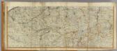
Netherlands (south)
1 : 250000 Kitchin, Thomas; Robert Laurie & James Whittle
Comitatuum Hannoniae Et Namurci Descriptio. [Karte], in: Novus atlas absolutissimus, Bd. 3, S. 144.
1 Karte aus Atlas Janssonius Offizin
Carte du Pais situe entre Peronne Guise Mons Lille et Bethune
1 : 200000 Mollova mapová sbírka Le Rouge, Georges-Louis Le Rouge, Georges-Louis
Comitatuum Hannoniae Et Namurci Descriptio. [Karte], in: Theatrum orbis terrarum, sive, Atlas novus, Bd. 1, S. 394.
1 Karte aus Atlas Blaeu, Joan Blaeu, Willem Janszoon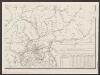
Comitatuum Hannoniae Et Namurci Descriptio. [Karte], in: Le théâtre du monde, ou, Nouvel atlas contenant les chartes et descriptions de tous les païs de la terre, Bd. 1, S. 377.
1 Karte aus Atlas Blaeu, Willem Janszoon und Blaeu, Joan Blaeu, Willem Janszoon
La Basse Partie De L'Estat Et Seigneurie De L'Evesché De Lyege &c. [Karte], in: Atlas nouveau, contenant toutes les parties du monde [...], Bd. 1, S. 210.
1 Karte aus Atlas Sanson, Nicolas Jaillot, Alexis Hubert und Mortier, Pieter
Leodiensis Dioecesis. [Karte], in: Theatrum orbis terrarum, sive, Atlas novus, Bd. 1, S. 403.
1 Karte aus Atlas Blaeu, Joan Blaeu, Willem Janszoon
Leodiensis Dioecesis. [Karte], in: Le théâtre du monde, ou, Nouvel atlas contenant les chartes et descriptions de tous les païs de la terre, Bd. 1, S. 369.
1 Karte aus Atlas Blaeu, Willem Janszoon und Blaeu, Joan Blaeu, Willem Janszoon
Leodiensis Dioecesis. [Karte], in: Novus Atlas, das ist, Weltbeschreibung, Bd. 1, S. 342.
1 Karte aus Atlas Blaeu, Joan Blaeu, Willem Janszoon
LEODIENSIS | DIOECESIS.
Amsterdami | Apud Guiljelmum et Ioannem Blaeu.

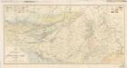
Sheet 7, uit: Stanford's large scale map of the seat of war / Stanford's Geographical Estab[lishmen]t
1 : 300000 Stanford's Geographical Establishment, Londen London : Stanford
5) II.O. ''Bruxelles'', uit: Carte géologique de France
1 : 500000 Annotatie: Voor aanwezige bladen zie bladoverzicht [S.l : s.n.]
Comitatus Hannoniae in suas quasque castellanias Balliviatvs praefecturas et territoria accurate divisi descriptio
1 : 230000 Belgie Homann, Johann Baptist J.B. Homann
Comitatus Hannoniae in suas quasque Castellanias Balliviatvs praefecturas et territoria accurate divisi descriptio
1 : 300000 Belgie Homann, Johann Baptist Ioh. Bapt. Homanno
Carte de la Picardie, Artois, Boulonois, Flandre françoise, Haynaut et Cambresis, 2
2 Blätter : 62 x 43 cm Bourgoin

Le Theatre de Bellone :
Mollova mapová sbírka Schenk, Pieter Braakman, Adriaan


