Maps of Götaland

[Dänemark und Süd-Schweden]
Neuer Handatlas über alle Theile der Erde Kiepert, Heinrich Verlag von Dietrich Reimer
Nord- und Ostseeherrschaft IV
1 : 7000000 Ostseeraum, Polen-Litauen, Deutscher Orden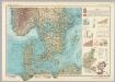
Southern Scandanavia. Pergamon World Atlas.
1 : 2500000 Polish Army Topography Service
[Schweden und Norwegen auch Dänemark, Südliches Blatt]
Hand-Atlas über alle Theile der Erde nach dem neuesten Zustande und über das Weltgebäude Stieler, Adolf bei Justus Perthes
Schweden und Norwegen auch Daenemark
Stieler's Hand-Atlas Stieler, Adolf bei Justus Perthes
Denmark Sweden and Russia on the Baltic.
1 : 3380000 Sharpe, J.

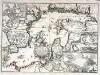
Ostsee.
1 : 2150000 Radefeld, Carl Christian Franz, 1788-1874
Die Ostsee
Grosser Hand-Atlas über alle Theile der Erde in 170 Karten Meyer, J. Verlag des Bibliographischen Instituts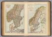
S. Scandinavia, Norway, Sweden.
1 : 4000000 Andree, Richard; Times (London, England)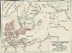
Nord- und Ostseeherrschaft II: Reich Waldemars II.
1 : 10000000 Ostseeraum Valdemar II., Danmark, Konge
Uebersichtskarte von der Ost - See und den anliegenden Ländern

Carte réduite de la mer Baltique, 1
1 Blatt : 73 x 60 cm Froullé
Postkarte von Schweden Ansich, von Gothland und von Norwegen
Gotland (Švédsko) Ponheimer, Kilian im von Reillyschen Landkarten und Kunstwerke Verschleiss Komptoir
Daniae Regni Typus. [Karte], in: Theatrum orbis terrarum, S. 56.
1 Karte aus Atlas Ortelius, Abraham
Denmark.
from A system of geography, or, A new & accurate description of the earth in all its empires, kingdoms and states : illustrated with history and topography, and maps of every country : fairly engraven on copper, according to the latest discoveries and corrections / by Herman Moll.
Turkart over Hallingskarvet
Statens Kartverk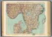
63-64. Svezia, Norvegia meridionale.
1 : 1500000 Touring club italiano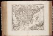
Gothia
1 : 1500000 Annotatie: Rechtsboven: XXII; Origineel is Blad 143 in atlas factice; Annotatie geografische gegevens: Schaalstokken op de kaart: Milliaria Westrogothica quorum 8 1/2 uni grad. respondent, en: Milliaria Ostrogothia quorum 12 uni grad. respondent [Amsterdam etc. : apud Janssonio-Waesbergios et Mosem Pitt]
Southern Scandinavia & Denmark.
1 : 2000000 John Bartholomew and Son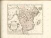
Accurate geographische Vorstellung der Ost-See
1 Karte : Kupferdruck ; 41 x 58 cm Riegel verlegt beÿ Christoph Riegel Buch- und Kunsthändlern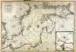
Nieuwe caart van de Oost Zee
1 Karte : Kupferdruck ; 58 x 85 cm chez Jean Cóvens et Corneille Mortier
Carte de la mer Baltique
1 Karte : Kupferdruck ; 60 x 88 cm Jaillot; Loon s.n.
[Daenemark mit Schleswig, Holstein, und Lauenburg; Island u. Fär-Öer]
Schul-Atlas über alle Theile der Erde nach dem neuesten Zustande, und über das Weltgebäude Stieler, Adolf Justus Perthes
Südskandinavien
1 : 2500000 Oslo (Norsko) Justus Perthes
Pas-Caart van de Oost Zee Verthonede Alle de gelegentheydt tusschen 't Eylandt Rugen ende Wyburg [Karte in 2 Teilen], in: De Nieuwe Groote Vermeerderde Zee-Atlas ofte Water-Werelt, S. 25.
1 Karte aus Atlas Doncker, Hendrick
Gothia [Karte], in: Novus atlas absolutissimus, Bd. 1, S. 54.
1 Karte aus Atlas Janssonius Offizin
Gothia [Karte], in: Theatrum orbis terrarum, sive, Atlas novus, Bd. 1, S. 56.
1 Karte aus Atlas Blaeu, Joan Blaeu, Willem Janszoon
![[Dänemark und Süd-Schweden]](https://images-2.georeferencer.com/images/iiif/298750912680/full/,300/0/native.jpg)

