Maps of Italy

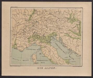
Die Alpen
Plastischer Schul-Atlas über alle Theile der Erde : in 24 Karten Woldermann, G Verlag von P. Eckerlein
General-Karte von Deutschland, der batavischen und helvetischen Republik, ober und mittel Italien und dem ostlichen Theil der franzosischen Republik... nach den Bestimmungen der neuesten Friedens-Schlusse und Conventionen, ingleichen nach astronomischen Ortsbestimungen und den verzuglichsten Hulfsmitteln, auf Kosten der konig. Akad. der Wissenschaften in Berlin
1 : 2018182 Sotzmann, Daniel Friedrich 1754-1840 Berlin :
Carta delle poste e stazioni militari per le provincie d'Italia
1 : 7550000 Itálie
Carta delle poste e stazioni militari per le provincie d'Italia
1 : 7550000 Itálie
Carta delle poste e stazioni militari per le provincie d'Italia
1 : 7550000 Itálie
Carta delle poste e stazioni militari per le provincie d'Italia
1 : 7550000 Itálie Istituto geografico millitare
Carta delle poste e stazioni militari per le provincie d'Italia
1 : 7550000 Itálie
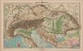
Alpenland
E. von Sydow's Schul-Atlas in sechs und dreissig Karten Sydow, Emil von bei Justus Perthes
Carte des confins de la France et des principales postes, de Paris aux païs estrangers
1 Karte : Kupferdruck ; 43 x 44 cm Placide de Sainte Hélène; Duval chez M.elle Du-Ual sur le quay de l'orloge prés le coin de la rüe de Harlay a l'ancien buïs
[Kaart], uit: Stanford's map of North Italy & surrounding countries : including Rome, Paris & Vienna
1 : 1750000 London : Edward Stanford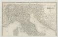
Italia
1 : 1140000 Sacchi, Ferd. Ditta Artaria di Ferd.o Sacchi e figli
[Atlas zur Geschichte von Bayern] : IIIa. Die Besitzungen der Welfen und Hohenstaufen im XIIten Jahrhundts. IIIb. Die südöstlichen Marken Deutschland’s bis zur Gründung der Herzogthümer Oesterreich & Steyermark
K. v. Spruner [Gotha : Perthes]
Italia superior, Rhaetia, Noricum, Pannonia, Daciae et Illyrici partes occidentales
1 : 1880000 Dácie Reichard, Christian Gottlieb Campius, D. a D. Campio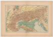
Carta delle Alpi / dir. G. Garollo ; Francesco Vallardi
1 : 2500000 G. Garollo Francesco Vallardi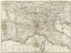
Carte Generale du Theatre de la Guerre en Italie ou sont marquées toutes les Routes que l'on peut tenir tant de France, depuis Paris, que d'Allemagne de puis Vienne en Autriche pour allere a Milan, a Venise, a Florence a Rome a Naples et autres Villes considerables sur ees Routes
1 : 3800000 Mollova mapová sbírka Nolin, Jean-Baptiste Nolin, Jean Baptiste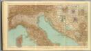
24-26. Italia nord.
1 : 1500000 Touring club italiano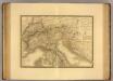
Italie, Suisse, Illyrie nord.
1 : 2100000 Picquet, C.
Strassen Karte der Alpen und des nördlichen Apennin
1 : 1850000 Alpy (pohoří) Berghaus, Hermann Justus Perthes
Österreich-Ungarn und Alpenländer. Bodengestalt
1 : 4000000 Österreich-Ungarn Physische Geografie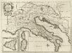
Antiquorum Italiae & Illyrici :
1 : 3400000 Mollova mapová sbírka Sanson, Nicolas Covens, Johannes I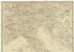
Italien
Itálie severní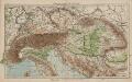
Österreich-Ungarn und Alpenländer
1 : 4000000 Österreich-Ungarn
Alpenlander.
1 : 1250000 Berghaus, Hermann
Austria.
from Abraham Ortelius his epitome of the theater of the worlde / nowe latlye ... renewed and augmented ... by Micheal Coignet, mathematitian of Antwarpe.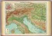
Northern Italy, Austria, &c.
1 : 2000000 John Bartholomew and Son
Illyricum Occidentis
1 : 3000000 Mollova mapová sbírka Sanson, Nicolas Covens, Johannes I
Illyrivcum Occidentis
1 : 1300000 Mollova mapová sbírka Sanson, Nicolas Cordier, Louis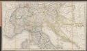
[Post und Reisekarte von Italien und den nördlich angrenzenden Alpenländern]
1 : 1800000 Roost, Johann Baptist J.G. Cotta
Ober und Mittel Italien