Maps of Český Brod

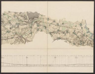
Eisenbahn Karte Wien-Dresden, Ollmütz-Trübau
1 : 72000 Blatt 12 Minarzik, Anselm J. Rauh
Podrobné mapy zemí Koruny české v měřítku 1:75.000 a mapa vzdáleností všech míst při silnici ležících - Český Brod – Kouřim. Průvodce statisticko-historický po všech místech na těchto mapách uvedených a rejstřík věcný názvů hor, potoků, řek, rybníků atd. Sešit 14. List 68,
1 : 75000
Podrobné mapy zemí Koruny české v měřítku 1:75.000 a mapa vzdáleností všech míst při silnici ležících
1 : 75000 Kouřim (Česko : oblast) Bělohlav, Josef F. Topič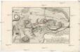
Plan der Bataille welche den 18. Junii 1757 von der kayserlich königlich-ungarischen und königlich preussischen Armée in Böhmen ohnweit Planian und Collin bey Chotzemitz geliefert worden.
Kolín-oblast (Česko) Čermak, Jan Grale, Conrad
[Gradkartenblatt]
1 : 25000 Čechy (Česko) Vojenský zeměpisný ústav
III. vojenské mapování 3954/3
1 : 25000
III. vojenské mapování 3954/3
1 : 25000
Gradkartenblatt
1 : 25000 Čechy (Česko) Czechák, Carl
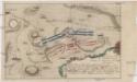
Accurater Plan der Bataille ohnweit Planian und Kaurzim bey dem Dorff Chotzemitz
Kolín-oblast (Česko)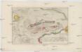
Accurater Plan der Bataille ohnweit Planian und Kaurzim bey dem Dorffe Chotzemitz
Kolín-oblast (Česko)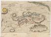
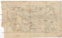
Plan der Bataille ohnweit Planian und Kaurzim bey Chotzemitz welche den 18. Juny 1757 zwischen denen kayserl. königl. hung. böhmisch. und königlich preusischen Arméen vorgefallen, allwo nach 7. mahligem Angriff, die Preusische sich retiriret, und die k. k. das Feld beh[au]ptet
Kolín-oblast (Česko)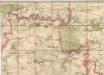
Mapa politického a školního okresu Českobrodského

Umgebung v. Kauržim
Kouřim-oblast (Česko) Biller, Bernhardt Marco Berra
Labe u Veltrub

Wahrhaffter Entwurff der bey Chotzemitz zwischen der kaiserlichen und koenio. [sic] preüss. Armee vorgefallenen Haubt-Bataille den 18ten Juny A. 1757
Kolín-oblast (Česko) Dilling Mentzel, J. G.
Bestandeskarte für die Excursion des böhmischen Forstvereines im August 1896 auf der Domaine Poděbrad nach Befund des Wirtschaftjahres 1896
1 : 17280 Poděbrady-oblast (Česko) Voborník, Fr.
Bestandeskarte sammt nächster Umgebung für die Excursion des böhmischen Forstvereines im Juli 1907 auf der Domaine Poděbrad nach Befund des Wirtschaftjahres 1907
Poděbrady-oblast (Česko) Voborník, F. Renard Kartografie Ant. Vítek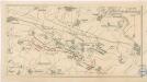
Bez titulu: Bitva u Kolína 18. června 1757
Bojiště u Kolína v podobě před sto lety
1 : 55000 Kolín-oblast (Česko)
Plan der Bataille bey Collin so zwischen der kayser. könig. Armée unter Commando sr. Excellentz des Herren General Feld-Marschalls Leopold Graffen v. Daun und der könig. preussischen Armée, unter Com[m]ando ihro Maj. des Königs, den 18ten Junii 1757 vorgefallen.
Kolín-oblast (Česko) Erdmann, F. G. Mikolášek, Antonín
Messtisch-Aufnahme von Juni und Juli 1876 der Elbepartie nächst Weltrub
1 : 8700 Labe (Česko a Německo) Mayr, Josef Fiala, Franz
Kaunitz (Kaunice) - c3423-1-008 - Kaiserpflichtexemplar der Landkarten des stabilen Katasters
1 : 2880
Kaunitz (Kaunice) - c3423-1-005 - Kaiserpflichtexemplar der Landkarten des stabilen Katasters
1 : 2880
Kaunitz (Kaunice) - c3423-1-007 - Kaiserpflichtexemplar der Landkarten des stabilen Katasters
1 : 2880
Kaunitz (Kaunice) - c3423-1-003 - Kaiserpflichtexemplar der Landkarten des stabilen Katasters
1 : 2880
Kaunitz (Kaunice) - c3423-1-001 - Kaiserpflichtexemplar der Landkarten des stabilen Katasters
1 : 2880
Kaunitz (Kaunice) - c3423-1-002 - Kaiserpflichtexemplar der Landkarten des stabilen Katasters
1 : 2880
Kaunitz (Kaunice) - c3423-1-004 - Kaiserpflichtexemplar der Landkarten des stabilen Katasters
1 : 2880