Maps of Uhlířov

Köhlersdorf (Ullerow) - m3199-1-002 - Kaiserpflichtexemplar der Landkarten des stabilen Katasters
1 : 2880
Köhlersdorf (Ullerow) - m3199-1-003 - Kaiserpflichtexemplar der Landkarten des stabilen Katasters
1 : 2880
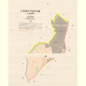
Köhlersdorf (Ullerow) - m3199-1-001 - Kaiserpflichtexemplar der Landkarten des stabilen Katasters
1 : 2880
Karte der Umgebung von Troppau

Benkowitz (Benkowice) - m0052-1-003 - Kaiserpflichtexemplar der Landkarten des stabilen Katasters
1 : 2880
Benkowitz (Benkowice) - m0052-1-001 - Kaiserpflichtexemplar der Landkarten des stabilen Katasters
1 : 2880
Benkowitz (Benkowice) - m0052-1-002 - Kaiserpflichtexemplar der Landkarten des stabilen Katasters
1 : 2880
Schlakau (Slawkow) - m2775-1-003 - Kaiserpflichtexemplar der Landkarten des stabilen Katasters
1 : 2880
Schlakau (Slawkow) - m2775-1-002 - Kaiserpflichtexemplar der Landkarten des stabilen Katasters
1 : 2880
Schlakau (Slawkow) - m2775-1-001 - Kaiserpflichtexemplar der Landkarten des stabilen Katasters
1 : 2880
Schlakau (Slawkow) - m2775-1-005 - Kaiserpflichtexemplar der Landkarten des stabilen Katasters
1 : 2880
Schlakau (Slawkow) - m2775-1-006 - Kaiserpflichtexemplar der Landkarten des stabilen Katasters
1 : 2880
Schlakau (Slawkow) - m2775-1-004 - Kaiserpflichtexemplar der Landkarten des stabilen Katasters
1 : 2880
Stablowitz - m3038-1-004 - Kaiserpflichtexemplar der Landkarten des stabilen Katasters
1 : 2880
Stablowitz - m3038-1-001 - Kaiserpflichtexemplar der Landkarten des stabilen Katasters
1 : 2880
Stablowitz - m3038-1-005 - Kaiserpflichtexemplar der Landkarten des stabilen Katasters
1 : 2880
Stablowitz - m3038-1-003 - Kaiserpflichtexemplar der Landkarten des stabilen Katasters
1 : 2880
Stablowitz - m3038-1-002 - Kaiserpflichtexemplar der Landkarten des stabilen Katasters
1 : 2880

Opava a okolí
1 : 75000 Opava (Česko : oblast) Vojenský zeměpisný ústav
Karte der Umgebung von Troppau

Opava
1 : 75000 Bílovec (Česko : oblast) Vojenský zeměpisný ústav
Opava
1 : 75000 Bílovec (Česko : oblast) Kartografické odd. při Min. nár. obrany
Troppau
1 : 75000 Morava (Česko) Schuberth K. u. k. Militärgeographisches Institut
Bez titulu: Plán bitvy u Opavy

Podrobná mapa Markrabství moravského a Vévodství slezkého
1 : 100000 Bílovec (Česko : oblast) Srp, Jan Jos. R. Vilímek
Podrobná místopisná mapa Království Českého

Troppau
from Spezialkarte der osterreichisch-ungarischen Monarchie.