Maps of okres Žďár nad Sázavou

Olleschinek (Ollessinky) - m2124-1-002 - Kaiserpflichtexemplar der Landkarten des stabilen Katasters
1 : 2880
Olleschinek (Ollessinky) - m2124-1-001 - Kaiserpflichtexemplar der Landkarten des stabilen Katasters
1 : 2880
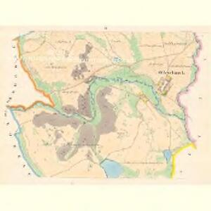
Ratschitz (Račice) - m2500-1-002 - Kaiserpflichtexemplar der Landkarten des stabilen Katasters
1 : 2880
Ratschitz (Račice) - m2500-1-001 - Kaiserpflichtexemplar der Landkarten des stabilen Katasters
1 : 2880
Swolla - m3616-1-003 - Kaiserpflichtexemplar der Landkarten des stabilen Katasters
1 : 2880
Swolla - m3616-1-006 - Kaiserpflichtexemplar der Landkarten des stabilen Katasters
1 : 2880
Swolla - m3616-1-005 - Kaiserpflichtexemplar der Landkarten des stabilen Katasters
1 : 2880
Swolla - m3616-1-001 - Kaiserpflichtexemplar der Landkarten des stabilen Katasters
1 : 2880
Swolla - m3616-1-002 - Kaiserpflichtexemplar der Landkarten des stabilen Katasters
1 : 2880
Swolla - m3616-1-004 - Kaiserpflichtexemplar der Landkarten des stabilen Katasters
1 : 2880
Ober Bobrau (Bobrowa Hornj) - m0767-1-005 - Kaiserpflichtexemplar der Landkarten des stabilen Katasters
1 : 2880
Ober Bobrau (Bobrowa Hornj) - m0767-1-003 - Kaiserpflichtexemplar der Landkarten des stabilen Katasters
1 : 2880
Ober Bobrau (Bobrowa Hornj) - m0767-1-004 - Kaiserpflichtexemplar der Landkarten des stabilen Katasters
1 : 2880
Ober Bobrau (Bobrowa Hornj) - m0767-1-002 - Kaiserpflichtexemplar der Landkarten des stabilen Katasters
1 : 2880
Ober Bobrau (Bobrowa Hornj) - m0767-1-001 - Kaiserpflichtexemplar der Landkarten des stabilen Katasters
1 : 2880
Miroschau (Mirossow) - m1812-1-001 - Kaiserpflichtexemplar der Landkarten des stabilen Katasters
1 : 2880
Miroschau (Mirossow) - m1812-1-003 - Kaiserpflichtexemplar der Landkarten des stabilen Katasters
1 : 2880
Miroschau (Mirossow) - m1812-1-002 - Kaiserpflichtexemplar der Landkarten des stabilen Katasters
1 : 2880
Miroschau (Mirossow) - m1812-1-004 - Kaiserpflichtexemplar der Landkarten des stabilen Katasters
1 : 2880
Miroschau (Mirossow) - m1812-1-005 - Kaiserpflichtexemplar der Landkarten des stabilen Katasters
1 : 2880
Gradkartenblatt
1 : 25000 Bystřice nad Pernštejnem-oblast (Česko) Goršić, Josef

G. Meseritsch
1 : 75000 Velká Bíteš (Česko : oblast) Ansion K. u. k. Militärgeographisches Institut
Special - Karte des Koenigreiches Boehmen

Podrobná mapa Království českého
1 : 100000 Bystré (Svitavy, Česko) Srp, Jan Jos. R. Vilímek
Podrobná místopisná mapa Království Českého

Podrobná mapa Markrabství moravského a Vévodství slezkého
1 : 100000 Bystré (Svitavy, Česko) Srp, Jan Jos. R. Vilímek
Mapa politického okresu Velko-Meziříčského
1 : 88500 Velká Bíteš-oblast (Česko) Šádek, Jindřich J.F. Šašek
II. vojenské mapování 8
1 : 144000