Maps of Kácov

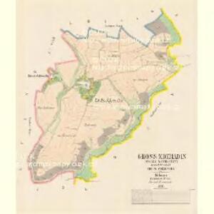
Gross Zderadin (Welky Zderadiny) - c9216-1-001 - Kaiserpflichtexemplar der Landkarten des stabilen Katasters
1 : 2880
Klein Zderadin (Maly Zderadiny) - c9215-1-002 - Kaiserpflichtexemplar der Landkarten des stabilen Katasters
1 : 2880
Klein Zderadin (Maly Zderadiny) - c9215-1-001 - Kaiserpflichtexemplar der Landkarten des stabilen Katasters
1 : 2880
Polipes - c5989-1-004 - Kaiserpflichtexemplar der Landkarten des stabilen Katasters
1 : 2880
Polipes - c5989-1-005 - Kaiserpflichtexemplar der Landkarten des stabilen Katasters
1 : 2880
Polipes - c5989-1-001 - Kaiserpflichtexemplar der Landkarten des stabilen Katasters
1 : 2880
Polipes - c5989-1-006 - Kaiserpflichtexemplar der Landkarten des stabilen Katasters
1 : 2880
Polipes - c5989-1-002 - Kaiserpflichtexemplar der Landkarten des stabilen Katasters
1 : 2880
Polipes - c5989-1-003 - Kaiserpflichtexemplar der Landkarten des stabilen Katasters
1 : 2880
III. vojenské mapování 4054/3
1 : 25000
III. vojenské mapování 4054/3
1 : 25000
Gradkartenblatt
1 : 25000 Čechy (Česko) Czechák, Carl

Kutná Hora
1 : 75000 Kutná Hora (Česko : oblast) Vojenský zeměpisný ústav
Kuttenberg und Kohljanowitz
1 : 75000 Kutná Hora (Česko : oblast) Kotrtsch K. u. k. militär-geographisches Institut
Kuttenberg und Kohljanowitz
1 : 75000 Kutná Hora (Česko : oblast) Kotrtsch K. u. k. Militärgeographisches Institut
Kuttenberg und Kohljanowitz
1 : 75000 Kutná Hora (Česko : oblast) K. u. k. Militärgeographisches Institut
Mapy plánování ČSR

Bystřický vikariát
Bystřice (Benešov, Česko)
III. vojenské mapování 4054
1 : 75000
Karte des Gemeindegrenzen

Podrobná mapa Království českého
1 : 100000 Ledeč nad Sázavou (Česko : oblast) Srp, Jan Jaroslav Bursík
[Vilímkovy místopisné mapy zemí Koruny české]
1 : 100000 Ledeč nad Sázavou (Česko : oblast) Srp, Jan Jos. R. Vilímek
Politický okres Ledeč nad Sázavou
1 : 100000 Ledeč nad Sázavou-oblast (Česko) Kratochvíl, M. Josef Richard Vilímek
Politický okres Vlašim
1 : 100000 Vlašim-oblast (Česko) Kratochvíl, M. Josef Richard Vilímek
Politický okres Kutná Hora
1 : 100000 Kutná Hora (Česko : okres : 1960-) Kratochvíl, M. Josef Richard Vilímek
[Beneschau und Umgebung]
1 : 144000 Benešov-oblast (Česko) Kořistka, Karel František Edvard
Politický okrec Benešovský

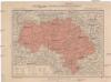
Kuttenberg und Kohljanowitz.
from Spezialkarte der osterreichisch-ungarischen Monarchie.