Maps of Zádub-Závišín

Hohendorf - c9038-1-001 - Kaiserpflichtexemplar der Landkarten des stabilen Katasters
1 : 2880
Hohendorf - c9038-1-002 - Kaiserpflichtexemplar der Landkarten des stabilen Katasters
1 : 2880
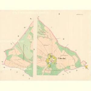
Abaschin (Zawissjn) - c9164-1-001 - Kaiserpflichtexemplar der Landkarten des stabilen Katasters
1 : 2880
Abaschin (Zawissjn) - c9164-1-004 - Kaiserpflichtexemplar der Landkarten des stabilen Katasters
1 : 2880
Abaschin (Zawissjn) - c9164-1-003 - Kaiserpflichtexemplar der Landkarten des stabilen Katasters
1 : 2880
Abaschin (Zawissjn) - c9164-1-002 - Kaiserpflichtexemplar der Landkarten des stabilen Katasters
1 : 2880
Wilkowitz (Wilkowice) - c8709-1-002 - Kaiserpflichtexemplar der Landkarten des stabilen Katasters
1 : 2880
Wilkowitz (Wilkowice) - c8709-1-003 - Kaiserpflichtexemplar der Landkarten des stabilen Katasters
1 : 2880
Wilkowitz (Wilkowice) - c8709-1-001 - Kaiserpflichtexemplar der Landkarten des stabilen Katasters
1 : 2880
Umgebung von Marienbad
1 : 11000 Mariánské Lázně (Česko) F.Gschihay
Umgebung von Marienbad
1 : 12500 Mariánské Lázně-oblast (Česko) Soukup K. k. militär. geografisches Institut
Marienbad
1 : 11520 Mariánské Lázně (Česko) Líčka, Josef Franz Řivnáč
Umgebung von Marienbad
1 : 11000 Mariánské Lázně (Česko) F.Gschihay
Müllestau (Milhossow) - c4662-1-001 - Kaiserpflichtexemplar der Landkarten des stabilen Katasters
1 : 2880
Müllestau (Milhossow) - c4662-1-002 - Kaiserpflichtexemplar der Landkarten des stabilen Katasters
1 : 2880
Situationsplan vom Curorte Marienbad mit Umgebung
Mariánské Lázně (Česko : oblast) E. A. Götz
Auschowitz (Aussowice) - c8277-1-004 - Kaiserpflichtexemplar der Landkarten des stabilen Katasters
1 : 2880
Auschowitz (Aussowice) - c8277-1-003 - Kaiserpflichtexemplar der Landkarten des stabilen Katasters
1 : 2880
Auschowitz (Aussowice) - c8277-1-001 - Kaiserpflichtexemplar der Landkarten des stabilen Katasters
1 : 2880
Auschowitz (Aussowice) - c8277-1-002 - Kaiserpflichtexemplar der Landkarten des stabilen Katasters
1 : 2880
Auschowitz (Aussowice) - c8277-1-005 - Kaiserpflichtexemplar der Landkarten des stabilen Katasters
1 : 2880
Situationsplan der Curstadt Marienbad

[Mariánské Lázně]
1 : 8300 Mariánské Lázně (Česko) E.A. Götz
[Podhorn Mühle]

Přehledná mapa panství Planá
1 : 25000
Gradkartenblatt
1 : 25000 Mariánské Lázně-oblast (Česko) Böhm, Karl
Mariánské Lázně
1 : 30000 Mariánské Lázně-oblast (Česko) Frank Tetour, Bohumil Voj. zeměpisný ústav
[Kartenblatt]
1 : 25000 Chodová Planá (Česko : oblast) Reichsamt für Landesaufnahme
III. vojenské mapování 4049/2
1 : 25000