Maps of Nová Ves nad Nisou

Seidenschwanz (Wrkoslawice) - c8859-1-004 - Kaiserpflichtexemplar der Landkarten des stabilen Katasters
1 : 2880
Seidenschwanz (Wrkoslawice) - c8859-1-003 - Kaiserpflichtexemplar der Landkarten des stabilen Katasters
1 : 2880
Seidenschwanz (Wrkoslawice) - c8859-1-001 - Kaiserpflichtexemplar der Landkarten des stabilen Katasters
1 : 2880
Seidenschwanz (Wrkoslawice) - c8859-1-002 - Kaiserpflichtexemplar der Landkarten des stabilen Katasters
1 : 2880
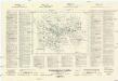
Übersichts-Plan der Stadt Gablonz a. N
1 : 8400 Jablonec nad Nisou (Česko) Richter, Al. Al. Richter
Gablonz (Gablonec) - c2727-1-001 - Kaiserpflichtexemplar der Landkarten des stabilen Katasters
1 : 2880
Gablonz (Gablonec) - c2727-1-004 - Kaiserpflichtexemplar der Landkarten des stabilen Katasters
1 : 2880
Gablonz (Gablonec) - c2727-1-003 - Kaiserpflichtexemplar der Landkarten des stabilen Katasters
1 : 2880
Gablonz (Gablonec) - c2727-1-002 - Kaiserpflichtexemplar der Landkarten des stabilen Katasters
1 : 2880
Übersichtsplan der Stadt Gablonz a/N.
Gablonz a/N.
Kreditanstalt der Deutschen registrierte Genossenschaft mit beschränkter Haftung
Jablonec nad Nisou (Česko : oblast) Weber-Ostwalden
Jablonec nad Nisou

Gablonz a/N.

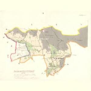
Neudorf (Nowa Wes) - c5220-1-002 - Kaiserpflichtexemplar der Landkarten des stabilen Katasters
1 : 2880
Neudorf (Nowa Wes) - c5220-1-005 - Kaiserpflichtexemplar der Landkarten des stabilen Katasters
1 : 2880
Neudorf (Nowa Wes) - c5220-1-003 - Kaiserpflichtexemplar der Landkarten des stabilen Katasters
1 : 2880
Neudorf (Nowa Wes) - c5220-1-001 - Kaiserpflichtexemplar der Landkarten des stabilen Katasters
1 : 2880
Neudorf (Nowa Wes) - c5220-1-004 - Kaiserpflichtexemplar der Landkarten des stabilen Katasters
1 : 2880
Kukan - c3270-1-001 - Kaiserpflichtexemplar der Landkarten des stabilen Katasters
1 : 2880
Kukan - c3270-1-002 - Kaiserpflichtexemplar der Landkarten des stabilen Katasters
1 : 2880
Karte des Forst-Reviers Schumburg
1 : 6000
Karte des Forst-Reviers Schumburg
1 : 6000
Radel (Radlo) - c6362-1-005 - Kaiserpflichtexemplar der Landkarten des stabilen Katasters
1 : 2880
Radel (Radlo) - c6362-1-008 - Kaiserpflichtexemplar der Landkarten des stabilen Katasters
1 : 2880
Radel (Radlo) - c6362-1-002 - Kaiserpflichtexemplar der Landkarten des stabilen Katasters
1 : 2880
Radel (Radlo) - c6362-1-007 - Kaiserpflichtexemplar der Landkarten des stabilen Katasters
1 : 2880
Radel (Radlo) - c6362-1-004 - Kaiserpflichtexemplar der Landkarten des stabilen Katasters
1 : 2880
Radel (Radlo) - c6362-1-003 - Kaiserpflichtexemplar der Landkarten des stabilen Katasters
1 : 2880
Radel (Radlo) - c6362-1-006 - Kaiserpflichtexemplar der Landkarten des stabilen Katasters
1 : 2880