Maps of Kadaň

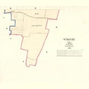
Würgnitz - c8849-1-002 - Kaiserpflichtexemplar der Landkarten des stabilen Katasters
1 : 2880
Würgnitz - c8849-1-001 - Kaiserpflichtexemplar der Landkarten des stabilen Katasters
1 : 2880
Pröhl - c6075-1-003 - Kaiserpflichtexemplar der Landkarten des stabilen Katasters
1 : 2880
Pröhl - c6075-1-001 - Kaiserpflichtexemplar der Landkarten des stabilen Katasters
1 : 2880
Pröhl - c6075-1-002 - Kaiserpflichtexemplar der Landkarten des stabilen Katasters
1 : 2880
Prösteritz - c6222-1-002 - Kaiserpflichtexemplar der Landkarten des stabilen Katasters
1 : 2880
Prösteritz - c6222-1-001 - Kaiserpflichtexemplar der Landkarten des stabilen Katasters
1 : 2880
Milsau - c4686-1-001 - Kaiserpflichtexemplar der Landkarten des stabilen Katasters
1 : 2880
Milsau - c4686-1-003 - Kaiserpflichtexemplar der Landkarten des stabilen Katasters
1 : 2880
Milsau - c4686-1-002 - Kaiserpflichtexemplar der Landkarten des stabilen Katasters
1 : 2880

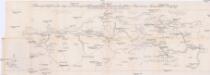
Orientierungs-Plan des Strassennetzes der Komotau-Sebastiansberger-Bez. Vertretung mit Inbegriff der eventuell zum Flusbau Kommenden Strassen-Strecken
1 : 75000 Chomutov-oblast (Česko) Loquens, Jos. Bormann, E.
Chomutov a okolí
1 : 75000 Chomutov (Česko : oblast) Vojenský zeměpisný ústav
Kaaden und Joachimsthal
1 : 75000 Jáchymov (Karlovy Vary, Česko : oblast) Leitner K. u. k. militär-geographisches Institut
Kaaden und Joachimsthal
1 : 75000 Jáchymov (Karlovy Vary, Česko : oblast) Leitner K. u. k. Militärgeographisches Institut
Kaaden und Joachimsthal
1 : 75000 Jáchymov (Karlovy Vary, Česko : oblast) K. u. k. Militärgeographisches Institut
Kadaň a Jáchymov
1 : 75000 Jáchymov (Karlovy Vary, Česko : oblast) Vojenský zeměpisný ústav
III. vojenské mapování 3850
1 : 75000
Vilímkovy místopisné mapy zemí Koruny české
1 : 100000 Chomutov (Česko : oblast) Srp, Jan Jos. R. Vilímek
Podrobná mapa Království českého
1 : 100000 Chomutov (Česko : oblast) Srp, Jan Jaroslav Bursík
III. vojenské mapování 3851
1 : 75000
Mapy plánování ČSR

Saaz und Komotau.
from Spezialkarte der osterreichisch-ungarischen Monarchie.
Kaaden und St. Joachimsthal.
from Spezialkarte der osterreichisch-ungarischen Monarchie.
Umgebungen von Kommotau und Saaz
1 : 750000 Chomutov (Česko : oblast) K. k. militär-geographisches Institut
Generalkarte der Bezirkshauptmannschaft Kaaden
1 : 220000 Kadaň-oblast (Česko) Wagner, Jan Eduard F. Kytka
Generalkarte der Bezirkshauptmannschaft Brüx
1 : 220000 Most-oblast (Česko) Wagner, Jan Eduard F. Kytka
Umgebungen von Kommotau und Saaz
Chomutov-oblast (Česko) Gargani, Ludwig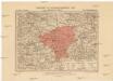
Generalkarte der Bezirkshauptmannschaft Saaz
1 : 220000 Žatec-oblast (Louny, Česko) Wagner, Jan Eduard F. Kytka