Maps of Městec Králové

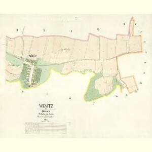
Winitz - c8600-1-001 - Kaiserpflichtexemplar der Landkarten des stabilen Katasters
1 : 2880
Winitz - c8600-1-002 - Kaiserpflichtexemplar der Landkarten des stabilen Katasters
1 : 2880
Königstadtl (Kraluwmiestec) - c4600-1-001 - Kaiserpflichtexemplar der Landkarten des stabilen Katasters
1 : 2880
Königstadtl (Kraluwmiestec) - c4600-1-009 - Kaiserpflichtexemplar der Landkarten des stabilen Katasters
1 : 2880
Königstadtl (Kraluwmiestec) - c4600-1-010 - Kaiserpflichtexemplar der Landkarten des stabilen Katasters
1 : 2880
Königstadtl (Kraluwmiestec) - c4600-1-006 - Kaiserpflichtexemplar der Landkarten des stabilen Katasters
1 : 2880
Königstadtl (Kraluwmiestec) - c4600-1-003 - Kaiserpflichtexemplar der Landkarten des stabilen Katasters
1 : 2880
Königstadtl (Kraluwmiestec) - c4600-1-007 - Kaiserpflichtexemplar der Landkarten des stabilen Katasters
1 : 2880
Königstadtl (Kraluwmiestec) - c4600-1-002 - Kaiserpflichtexemplar der Landkarten des stabilen Katasters
1 : 2880
Königstadtl (Kraluwmiestec) - c4600-1-004 - Kaiserpflichtexemplar der Landkarten des stabilen Katasters
1 : 2880
Königstadtl (Kraluwmiestec) - c4600-1-008 - Kaiserpflichtexemplar der Landkarten des stabilen Katasters
1 : 2880
Königstadtl (Kraluwmiestec) - c4600-1-005 - Kaiserpflichtexemplar der Landkarten des stabilen Katasters
1 : 2880
III. vojenské mapování 3954/2
1 : 25000
III. vojenské mapování 3954/2
1 : 25000
Gradkartenblatt
1 : 25000 Poděbrady-oblast (Česko) Ansion, Victor

Podrobné mapy zemí Koruny české v měřítku 1:75.000 a mapa vzdáleností všech míst při silnici ležících
1 : 75000 Libáň-oblast (Jičín, Česko) Bělohlav, Josef Kučera, Karel F. Topič
Podrobné mapy zemí Koruny české v měřítku 1:75.000 a mapa vzdáleností všech míst při silnici ležících - Libáň - Král. Městec - Nový Bydžov. Průvodce statisticko-historický po všech místech na těchto mapách uvedených a rejstřík věcný názvů hor, potoků, řek, rybníků atd. Sešit 19. List 80,
1 : 75000
III. vojenské mapování 3954
1 : 75000
Neu-Kolin
1 : 75000 Kolín (Česko : oblast) Ansion K. u. k. Militärgeographisches Institut
Neu-Kolin
1 : 75000 Kolín (Česko : oblast) K. u. k. Militärgeographisches Institut
Kolín (Kolin)
1 : 75000 Kolín (Česko : oblast) Zeměpisný ústav ministerstva vnitra
Karte des Gemeindegrenzen

Soubor přehledných map pro plánování a statistiku: 3954 – Kolín

Vilímkovy podrobné mapy politických okresů

Vilímkovy místopisné mapy zemí Koruny české
1 : 100000 Kolín (Česko : oblast) Srp, Jan Jos. R. Vilímek
Podrobná mapa Království českého
1 : 100000 Kolín (Česko : oblast) Srp, Jan Jaroslav Bursík
Okres poděbradský
1 : 100000 Poděbrady-oblast (Česko) Myška, Josef Mapový ateliér Ed. Fastra
Indikační skica mapy stabilního katastru pro město Přelouč VI.
1 : 2880