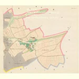
Maps of Vysoké Mýto

Wanitz - c8325-1-001 - Kaiserpflichtexemplar der Landkarten des stabilen Katasters
1 : 2880
Wanitz - c8325-1-002 - Kaiserpflichtexemplar der Landkarten des stabilen Katasters
1 : 2880
Indikační skica mapy stabilního katastru pro obec Sedlec IV
1 : 2880
Brtsch - c0534-1-001 - Kaiserpflichtexemplar der Landkarten des stabilen Katasters
1 : 2880
Brtsch - c0534-1-002 - Kaiserpflichtexemplar der Landkarten des stabilen Katasters
1 : 2880
Katastrální mapa pro obec Sedlec
1 : 2880
Lhutta - c3971-1-003 - Kaiserpflichtexemplar der Landkarten des stabilen Katasters
1 : 2880
Lhutta - c3971-1-001 - Kaiserpflichtexemplar der Landkarten des stabilen Katasters
1 : 2880
Lhutta - c3971-1-002 - Kaiserpflichtexemplar der Landkarten des stabilen Katasters
1 : 2880
Hohenmauth (Wisoky Megto) - c8959-1-016 - Kaiserpflichtexemplar der Landkarten des stabilen Katasters
1 : 2880
Hohenmauth (Wisoky Megto) - c8959-1-013 - Kaiserpflichtexemplar der Landkarten des stabilen Katasters
1 : 2880
Hohenmauth (Wisoky Megto) - c8959-1-005 - Kaiserpflichtexemplar der Landkarten des stabilen Katasters
1 : 2880
Hohenmauth (Wisoky Megto) - c8959-1-003 - Kaiserpflichtexemplar der Landkarten des stabilen Katasters
1 : 2880
Hohenmauth (Wisoky Megto) - c8959-1-014 - Kaiserpflichtexemplar der Landkarten des stabilen Katasters
1 : 2880
Hohenmauth (Wisoky Megto) - c8959-1-011 - Kaiserpflichtexemplar der Landkarten des stabilen Katasters
1 : 2880
Hohenmauth (Wisoky Megto) - c8959-1-009 - Kaiserpflichtexemplar der Landkarten des stabilen Katasters
1 : 2880
Hohenmauth (Wisoky Megto) - c8959-1-006 - Kaiserpflichtexemplar der Landkarten des stabilen Katasters
1 : 2880
Hohenmauth (Wisoky Megto) - c8959-1-012 - Kaiserpflichtexemplar der Landkarten des stabilen Katasters
1 : 2880
Hohenmauth (Wisoky Megto) - c8959-1-001 - Kaiserpflichtexemplar der Landkarten des stabilen Katasters
1 : 2880
Hohenmauth (Wisoky Megto) - c8959-1-015 - Kaiserpflichtexemplar der Landkarten des stabilen Katasters
1 : 2880
Hohenmauth (Wisoky Megto) - c8959-1-010 - Kaiserpflichtexemplar der Landkarten des stabilen Katasters
1 : 2880
Hohenmauth (Wisoky Megto) - c8959-1-008 - Kaiserpflichtexemplar der Landkarten des stabilen Katasters
1 : 2880
Hohenmauth (Wisoky Megto) - c8959-1-007 - Kaiserpflichtexemplar der Landkarten des stabilen Katasters
1 : 2880
Hohenmauth (Wisoky Megto) - c8959-1-002 - Kaiserpflichtexemplar der Landkarten des stabilen Katasters
1 : 2880
Hohenmauth (Wisoky Megto) - c8959-1-004 - Kaiserpflichtexemplar der Landkarten des stabilen Katasters
1 : 2880
Gradkartenblatt
1 : 25000 Vysoké Mýto-oblast (Česko) Hallada, Alois
III. vojenské mapování 4056/2
1 : 25000
III. vojenské mapování 4056/2
1 : 25000