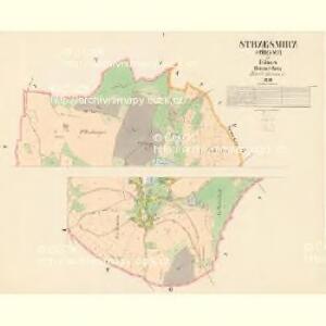
Maps of Střezimíř

Strzesmirz (Střesmiř) - c7462-1-002 - Kaiserpflichtexemplar der Landkarten des stabilen Katasters
1 : 2880
Strzesmirz (Střesmiř) - c7462-1-001 - Kaiserpflichtexemplar der Landkarten des stabilen Katasters
1 : 2880
Milostitz - c0356-2-002 - Kaiserpflichtexemplar der Landkarten des stabilen Katasters
1 : 2880
Milostitz - c0356-2-003 - Kaiserpflichtexemplar der Landkarten des stabilen Katasters
1 : 2880
Milostitz - c0356-2-001 - Kaiserpflichtexemplar der Landkarten des stabilen Katasters
1 : 2880
Milostitz - c0356-2-004 - Kaiserpflichtexemplar der Landkarten des stabilen Katasters
1 : 2880
Stupschitz - c7517-1-001 - Kaiserpflichtexemplar der Landkarten des stabilen Katasters
1 : 2880
Mezno - c4575-1-001 - Kaiserpflichtexemplar der Landkarten des stabilen Katasters
1 : 2880
Mezno - c4575-1-005 - Kaiserpflichtexemplar der Landkarten des stabilen Katasters
1 : 2880
Mezno - c4575-1-004 - Kaiserpflichtexemplar der Landkarten des stabilen Katasters
1 : 2880
Mezno - c4575-1-003 - Kaiserpflichtexemplar der Landkarten des stabilen Katasters
1 : 2880
Mezno - c4575-1-002 - Kaiserpflichtexemplar der Landkarten des stabilen Katasters
1 : 2880
III. vojenské mapování 4153/4
1 : 25000
[Tábor a okolí]
Soběslav (Česko)
Podrobné mapy zemí Koruny české v měřítku 1:75.000 a mapa vzdáleností všech míst při silnici ležících - Tábor - Milevsko - Sedlec. Průvodce statisticko-historický po všech místech na těchto mapách uvedených a rejstřík věcný názvů hor, potoků, řek, rybníků atd. Sešit 44. List 58,
1 : 75000
Podrobné mapy zemí Koruny české v měřítku 1:75.000 a mapy vzdáleností všech míst při silnici ležících
1 : 75000 Milevsko (Česko : oblast) Bělohlav, Josef F. Topič
Mapa okolí Tábora
1 : 76000 Tábor-oblast (Česko) Hemmr, Jan Václav Kraus
III. vojenské mapování 4153
1 : 75000
Sedlčany
1 : 75000 Sedlčany (Česko : oblast) Vojenský zeměpisný ústav
Sedlčany
1 : 75000 Sedlčany (Česko : oblast) Vojenský zeměpisný ústav
Selčan und Jung-Woschitz
1 : 75000 Mladá Vožice (Česko : oblast) Hertel, A. K. u. k. Militärgeographisches Institut
Selčan und Jung-Woschitz
1 : 75000 Mladá Vožice (Česko : oblast) K. u. k. Militärgeographisches Institut
Vilímkovy místopisné mapy zemí Koruny české
1 : 100000 Milevsko (Česko : oblast) Srp, Jan Jos. R. Vilímek
Podrobná mapa Království českého
1 : 100000 Milevsko (Česko : oblast) Srp, Jan Jaroslav Bursík
Politický okres Táborský
1 : 100000 Tábor-oblast (Česko) Srp, Jan Schwihlik, F. Jos. R. Vilímek
Okresní hejtmanství Sedlčanské

Selcan und Junc-Woschitz.
from Spezialkarte der osterreichisch-ungarischen Monarchie.
II. vojenské mapování 16
1 : 144000