Maps of Modřovice

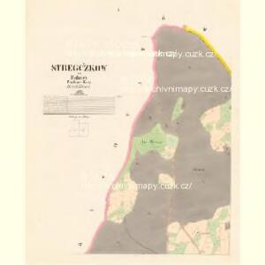
Stregčzkow - c7439-1-002 - Kaiserpflichtexemplar der Landkarten des stabilen Katasters
1 : 2880
Stregčzkow - c7439-1-001 - Kaiserpflichtexemplar der Landkarten des stabilen Katasters
1 : 2880
Stregčzkow - c7439-1-004 - Kaiserpflichtexemplar der Landkarten des stabilen Katasters
1 : 2880
Stregčzkow - c7439-1-003 - Kaiserpflichtexemplar der Landkarten des stabilen Katasters
1 : 2880
Wisoka - c8943-1-003 - Kaiserpflichtexemplar der Landkarten des stabilen Katasters
1 : 2880
Wisoka - c8943-1-001 - Kaiserpflichtexemplar der Landkarten des stabilen Katasters
1 : 2880
Wisoka - c8943-1-002 - Kaiserpflichtexemplar der Landkarten des stabilen Katasters
1 : 2880
Montan geologische Karte des Bergbau-terrains Přibram

Chrast - c2627-1-002 - Kaiserpflichtexemplar der Landkarten des stabilen Katasters
1 : 2880
Chrast - c2627-1-004 - Kaiserpflichtexemplar der Landkarten des stabilen Katasters
1 : 2880
Chrast - c2627-1-001 - Kaiserpflichtexemplar der Landkarten des stabilen Katasters
1 : 2880
Chrast - c2627-1-003 - Kaiserpflichtexemplar der Landkarten des stabilen Katasters
1 : 2880
Modřowitz (Mokřowic) - c4802-1-001 - Kaiserpflichtexemplar der Landkarten des stabilen Katasters
1 : 2880
Modřowitz (Mokřowic) - c4802-1-002 - Kaiserpflichtexemplar der Landkarten des stabilen Katasters
1 : 2880
Přehlední [sic] mapa velkostatků Tochovice, Břežnice Rožmitál
1 : 50000 Březnice (Příbram, Česko) Schrantz, Fr.
Plan der Herrschaft Rožmital im Prachiner Kreise

Karte des Příbramer Bezirkes im Prager Kreise
1 : 70000 Příbram-oblast (Česko) Wagner, Jan Eduard Karl André
Karte des Příbramer Bezirkes im Prager Kreise
1 : 70000 Příbram-oblast (Česko) Wagner, Jan Eduard Karl André

Přehlední [sic] mapa velkostatek Rožmital
1 : 50000 Rožmitál pod Třemšínem-oblast (Česko)
Soubor map okresů Pražského kraje

Mapa okresu Příbramského v Pražském kraji

Podrobné mapy zemí Koruny české v měřítku 1:75.000 a mapa vzdáleností všech míst při silnici ležících
1 : 75000 Dobříš (Česko : oblast) Bělohlav, Josef F. Topič
Přibram und Mirowitz
1 : 75000 Mirovice (Česko : oblast) Schill K. u. k. Militärgeographisches Institut
Přibram und Mirowitz
1 : 75000 Mirovice (Česko : oblast) K. u. k. Militärgeographisches Institut
III. vojenské mapování 4152
1 : 75000
Mapy plánování ČSR

Příbram
1 : 75000 Příbram (Česko : oblast) Vojenský zeměpisný ústav
Příbram
1 : 75000 Příbram-oblast (Česko) Vojenský zeměpisný ústav