Maps of Stehlovice

Stehlowitz - c7330-1-002 - Kaiserpflichtexemplar der Landkarten des stabilen Katasters
1 : 2880
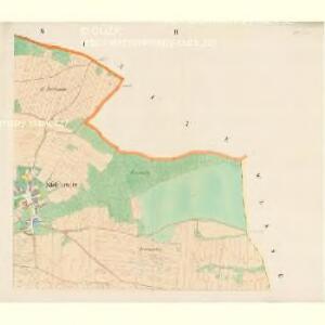
Stehlowitz - c7330-1-001 - Kaiserpflichtexemplar der Landkarten des stabilen Katasters
1 : 2880
Stehlowitz - c7330-1-003 - Kaiserpflichtexemplar der Landkarten des stabilen Katasters
1 : 2880
Branitz - c0460-1-001 - Kaiserpflichtexemplar der Landkarten des stabilen Katasters
1 : 2880
Branitz - c0460-1-002 - Kaiserpflichtexemplar der Landkarten des stabilen Katasters
1 : 2880
Branitz - c0460-1-003 - Kaiserpflichtexemplar der Landkarten des stabilen Katasters
1 : 2880
Branitz - c0460-1-004 - Kaiserpflichtexemplar der Landkarten des stabilen Katasters
1 : 2880
Wesseliczko - c8514-1-002 - Kaiserpflichtexemplar der Landkarten des stabilen Katasters
1 : 2880
Wesseliczko - c8514-1-001 - Kaiserpflichtexemplar der Landkarten des stabilen Katasters
1 : 2880
Jetětice, okr. Písek, list 2 1

Náčrty trigomometrické sítě velkostatku Orlíka, dochovány pro obce Nevězice - Varvažov, okolí Orlíka, Květov, Slavoňov, Jetětice, Těchnice, Lety, Vrábsko, Tukleky, Zvíkov, Bukovany, Zlákovice, Hrazany, Mýšlovice, list 4 1

Přehledná mapa panství Orlíka a přivtělených statků Bukovan, Zalužan a Zbenic, list 45 1

Krzenowitz - c3624-1-002 - Kaiserpflichtexemplar der Landkarten des stabilen Katasters
1 : 2880
Krzenowitz - c3624-1-001 - Kaiserpflichtexemplar der Landkarten des stabilen Katasters
1 : 2880
Krzenowitz - c3624-1-003 - Kaiserpflichtexemplar der Landkarten des stabilen Katasters
1 : 2880
Krzenowitz - c3624-1-005 - Kaiserpflichtexemplar der Landkarten des stabilen Katasters
1 : 2880
Krzenowitz - c3624-1-006 - Kaiserpflichtexemplar der Landkarten des stabilen Katasters
1 : 2880
Krzenowitz - c3624-1-007 - Kaiserpflichtexemplar der Landkarten des stabilen Katasters
1 : 2880
Krzenowitz - c3624-1-004 - Kaiserpflichtexemplar der Landkarten des stabilen Katasters
1 : 2880
Branice, okr. Písek, list 5 1
Mapy plánování ČSR


Plan der hochfürstlich Schwarzenbergischen Herrschaften Worlik und Klingenberg
1 : 41400 Bukovany (Příbram, Česko) Hertschl, Franz
Přehledná mapa panství Orlíka a přivtělených statků 1

Přehledná mapa velkostatku Orlíka, Čimelic a Varvažova s vyznačením hranic jednotlivých katastrálních obcí a pozemkové držby velkostatku s označením jednotlivých parcel 1

Přehledná mapa panství Orlíka a Zvíkova a přivtělených statků Bukovan, Zalužan a Zbenic 1

Písek a okolí
1 : 75000 Písek (Česko : oblast) Vojenský zeměpisný ústav
Přehledná mapa velkostatku Orlíka, Čimelic a Varvažova s vyznačením hranic jednotlivých katastrálních obcí a pozemkové držby velkostatku s označením jednotlivých parcel 1

Tabor
1 : 75000 Bechyně (Česko : oblast) Deppisch K. u. k. militär-geographisches Institut
Tabor
1 : 75000 Bechyně (Česko : oblast) Deppisch K. u. k. Militärgeographisches Institut