Maps of Lobendava

Hielgersdorf - c6854-2-002 - Kaiserpflichtexemplar der Landkarten des stabilen Katasters
1 : 2880
Hielgersdorf - c6854-2-004 - Kaiserpflichtexemplar der Landkarten des stabilen Katasters
1 : 2880
Hielgersdorf - c6854-2-003 - Kaiserpflichtexemplar der Landkarten des stabilen Katasters
1 : 2880
Hielgersdorf - c6854-2-001 - Kaiserpflichtexemplar der Landkarten des stabilen Katasters
1 : 2880
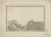
III. vojenské mapování 3552/4
1 : 25000
III. vojenské mapování 3552/4
1 : 25000
Lobendau - c4186-1-006 - Kaiserpflichtexemplar der Landkarten des stabilen Katasters
1 : 2880
Lobendau - c4186-1-007 - Kaiserpflichtexemplar der Landkarten des stabilen Katasters
1 : 2880
Lobendau - c4186-1-005 - Kaiserpflichtexemplar der Landkarten des stabilen Katasters
1 : 2880
Lobendau - c4186-1-003 - Kaiserpflichtexemplar der Landkarten des stabilen Katasters
1 : 2880
Lobendau - c4186-1-002 - Kaiserpflichtexemplar der Landkarten des stabilen Katasters
1 : 2880
Lobendau - c4186-1-001 - Kaiserpflichtexemplar der Landkarten des stabilen Katasters
1 : 2880
Lobendau - c4186-1-004 - Kaiserpflichtexemplar der Landkarten des stabilen Katasters
1 : 2880
Röhrsdorf - c4136-2-001 - Kaiserpflichtexemplar der Landkarten des stabilen Katasters
1 : 2880
Röhrsdorf - c4136-2-002 - Kaiserpflichtexemplar der Landkarten des stabilen Katasters
1 : 2880
III. vojenské mapování 3552/4
1 : 25000
Meßtischblatt 4951 : Neustadt, 1943
1 : 250000 Neustadt. - Ausg. 1941, Aufn. 1902, hrsg. 1905, bericht. 1932/38, letzte Nachtr. 1936. - 1:25000. - Leipzig, 1943. - 1 Kt.
Meßtischblatt [4951] : Neustadt, 1936
1 : 250000 Neustadt. - Umdr.-Ausg., aufgen. 1902, hrsg. 1905, bericht. 1932. - 1:25000. - Leipzig, 1936. - 1 Kt.
Meßtischblatt 69 : Neustadt, 1917
1 : 250000 Neustadt. - Aufgen. 1902, hrsg. 1911, einz. Nachtr. 1917. - 1:25000. - Leipzig, 1917. - 1 Kt.
Meßtischblatt 69 : Neustadt, 1912
1 : 250000 Neustadt. - Aufgen. 1902, hrsg. 1911, einz. Nachtr. 1912. - 1:25000. - Leipzig, 1912. - 1 Kt.
Meßtischblatt 69 : Neustadt, 1911
1 : 250000 Neustadt. - Aufgen. 1902. - 1:25000. - Leipzig, 1911. - 1 Kt.
Hainspach - c4122-3-004 - Kaiserpflichtexemplar der Landkarten des stabilen Katasters
1 : 2880
Hainspach - c4122-3-002 - Kaiserpflichtexemplar der Landkarten des stabilen Katasters
1 : 2880
Hainspach - c4122-3-001 - Kaiserpflichtexemplar der Landkarten des stabilen Katasters
1 : 2880
Hainspach - c4122-3-006 - Kaiserpflichtexemplar der Landkarten des stabilen Katasters
1 : 2880
Hainspach - c4122-3-003 - Kaiserpflichtexemplar der Landkarten des stabilen Katasters
1 : 2880
Hainspach - c4122-3-005 - Kaiserpflichtexemplar der Landkarten des stabilen Katasters
1 : 2880
Wanderkarte Bautzen und Umgebung
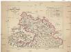
Charte des Rumburger Bezirk-Strafgerichtes
1 : 65000 Rumburk-oblast (Česko) Medau, Karel Vilém Lehrpersonale der Leitmeritzer Diöcesan- und Kreis-Hauptschule