Maps of Ratibořské Hory

Bergstädtl - c6464-1-001 - Kaiserpflichtexemplar der Landkarten des stabilen Katasters
1 : 2880
Bergstädtl - c6464-1-002 - Kaiserpflichtexemplar der Landkarten des stabilen Katasters
1 : 2880
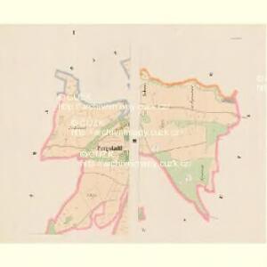
Wrzesetz - c8870-1-002 - Kaiserpflichtexemplar der Landkarten des stabilen Katasters
1 : 2880
Wrzesetz - c8870-1-001 - Kaiserpflichtexemplar der Landkarten des stabilen Katasters
1 : 2880
Wrzesetz - c8870-1-003 - Kaiserpflichtexemplar der Landkarten des stabilen Katasters
1 : 2880
Wrzesetz - c8870-1-004 - Kaiserpflichtexemplar der Landkarten des stabilen Katasters
1 : 2880
Ratiboržitz - c6463-1-002 - Kaiserpflichtexemplar der Landkarten des stabilen Katasters
1 : 2880
Ratiboržitz - c6463-1-004 - Kaiserpflichtexemplar der Landkarten des stabilen Katasters
1 : 2880
Ratiboržitz - c6463-1-003 - Kaiserpflichtexemplar der Landkarten des stabilen Katasters
1 : 2880
Ratiboržitz - c6463-1-001 - Kaiserpflichtexemplar der Landkarten des stabilen Katasters
1 : 2880
Dub - c1576-1-001 - Kaiserpflichtexemplar der Landkarten des stabilen Katasters
1 : 2880
Dub - c1576-1-003 - Kaiserpflichtexemplar der Landkarten des stabilen Katasters
1 : 2880
Dub - c1576-1-002 - Kaiserpflichtexemplar der Landkarten des stabilen Katasters
1 : 2880
Gradkartenblatt
1 : 25000 Tábor-oblast (Česko) Gravisi, Karl von
III. vojenské mapování 4253/2
1 : 25000
III. vojenské mapování 4253/2
1 : 25000

Polohopisná mapa silnic, cest a obecního majetku Táborského

Podrobné mapy zemí Koruny české v měřítku 1:75.000 a mapy vzdáleností všech míst při silnici ležících
1 : 75000 Milevsko (Česko : oblast) Bělohlav, Josef F. Topič
Podrobné mapy zemí Koruny české v měřítku 1:75.000 a mapy vzdáleností všech míst při silnici ležících
1 : 75000 Mladá Vožice (Česko : oblast) Bělohlav, Josef F. Topič
Polohopisná mapa silnic, cest a obecního majetku Táborského

III. vojenské mapování 4253
1 : 75000
Mapa okolí Tábora
1 : 76000 Tábor-oblast (Česko) Hemmr, Jan Václav Kraus
Mapy plánování ČSR

Tábor
1 : 75000 Tábor-oblast (Česko) Vojenský zeměpisný ústav
Tabor
1 : 75000 Bechyně (Česko : oblast) Deppisch K. u. k. militär-geographisches Institut
Tabor
1 : 75000 Bechyně (Česko : oblast) Deppisch K. u. k. Militärgeographisches Institut
Tabor
1 : 75000 Tábor (Česko : oblast) K. u. k. Militärgeographisches Institut
Podrobná mapa Království českého
1 : 100000 Milevsko (Česko : oblast) Srp, Jan Jaroslav Bursík