Maps of Kovářov

Radwanow - c6409-1-002 - Kaiserpflichtexemplar der Landkarten des stabilen Katasters
1 : 2880
Radwanow - c6409-1-001 - Kaiserpflichtexemplar der Landkarten des stabilen Katasters
1 : 2880
Radvánov s Bedřichovem, okr. Písek, list 3 1

Radvánov s Bedřichovem, okr. Písek, list 3 1

Březí s Hostínem a Zálužím, dnes obec Radvánov, okr. Písek, list 3 1

Zahoržan - c9053-1-005 - Kaiserpflichtexemplar der Landkarten des stabilen Katasters
1 : 2880
Zahoržan - c9053-1-004 - Kaiserpflichtexemplar der Landkarten des stabilen Katasters
1 : 2880
Zahoržan - c9053-1-001 - Kaiserpflichtexemplar der Landkarten des stabilen Katasters
1 : 2880
Zahoržan - c9053-1-002 - Kaiserpflichtexemplar der Landkarten des stabilen Katasters
1 : 2880
Zahoržan - c9053-1-003 - Kaiserpflichtexemplar der Landkarten des stabilen Katasters
1 : 2880
Přehledná mapa panství Orlíka a přivtělených statků Bukovan, Zalužan a Zbenic, list 17 1
Mapa dvora Lašovice 1

Žebrakow - c9378-1-002 - Kaiserpflichtexemplar der Landkarten des stabilen Katasters
1 : 2880
Žebrakow - c9378-1-003 - Kaiserpflichtexemplar der Landkarten des stabilen Katasters
1 : 2880
Žebrakow - c9378-1-001 - Kaiserpflichtexemplar der Landkarten des stabilen Katasters
1 : 2880
Mapa dvora Lašovice 1

Brzezy - c0566-1-002 - Kaiserpflichtexemplar der Landkarten des stabilen Katasters
1 : 2880
Brzezy - c0566-1-001 - Kaiserpflichtexemplar der Landkarten des stabilen Katasters
1 : 2880
Brzezy - c0566-1-003 - Kaiserpflichtexemplar der Landkarten des stabilen Katasters
1 : 2880
Mapa dvora Kovářova s tabelárním přehledem topogr. čísel, výměry a názvu polností 1

Kovářov, okr. Písek, list 1 1

Přílepov s Kotýřinou, Kroupovem, Slavoňovem a Vescí, okr. Písek, list 6 1
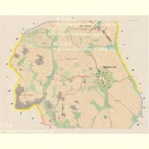
Panství Vorlík [sic]
1 : 25000 Orlík nad Vltavou-oblast (Česko) Jiskra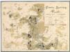
Porostní mapa severní části velkostatku orlického pro vycházku České lesnické jednoty v měsíci srpnu 1893 1
1 : 25000
Gradkartenblatt
1 : 25000 Milešov-oblast (Příbram, Česko) Siglitz, Franz

III. vojenské mapování 4152/4
1 : 25000
Přehledná mapa obrysová velkostatku Orlíka pro vycházku České lesnické jednoty s vyznačením trasy vycházky v r. 1877 a v r. 1890, použitá k označení názvů lesních dílů 1
1 : 75600
Mapy plánování ČSR