Maps of Kamenický Šenov

Schelten - c6077-1-001 - Kaiserpflichtexemplar der Landkarten des stabilen Katasters
1 : 2880
Schaiba - c5400-1-003 - Kaiserpflichtexemplar der Landkarten des stabilen Katasters
1 : 2880
Schaiba - c5400-1-001 - Kaiserpflichtexemplar der Landkarten des stabilen Katasters
1 : 2880
Schaiba - c5400-1-002 - Kaiserpflichtexemplar der Landkarten des stabilen Katasters
1 : 2880
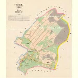
Steinschönau - c3008-1-003 - Kaiserpflichtexemplar der Landkarten des stabilen Katasters
1 : 2880
Steinschönau - c3008-1-004 - Kaiserpflichtexemplar der Landkarten des stabilen Katasters
1 : 2880
Steinschönau - c3008-1-001 - Kaiserpflichtexemplar der Landkarten des stabilen Katasters
1 : 2880
Steinschönau - c3008-1-005 - Kaiserpflichtexemplar der Landkarten des stabilen Katasters
1 : 2880
Steinschönau - c3008-1-002 - Kaiserpflichtexemplar der Landkarten des stabilen Katasters
1 : 2880
Charte zur Übersicht der im Leitmeritzer Kreise gelegenen Herrschaft Böhm. Kamnitz
1 : 70000 Česká Kamenice-oblast (Česko) Kreibich, František Jakub Jindřich Kettner, Carl
Charte zur Übersicht der im Leitmeritzer Kreise gelegenen Herrschaft Böhm. Kamnitz
1 : 70000 Česká Kamenice-oblast (Česko) Kreibich, František Jakub Jindřich Kettner, Carl
Charte zur Übersicht der im Leitmeritzer Kreise gelegenen Herrschaft Böhm. Kamnitz
1 : 70000 Česká Kamenice-oblast (Česko) Kreibich, František Jakub Jindřich Kettner, Carl
Charte zur Übersicht der im Leitmeritzer Kreise gelegenen Herrschaft Böhm. Kamnitz
1 : 70000 Česká Kamenice-oblast (Česko) Kreibich, František Jakub Jindřich Kettner, Carl
Charte zur Übersicht der im Leitmeritzer Kreise gelegenen Herrschaft Böhm. Kamnitz
1 : 70000 Česká Kamenice-oblast (Česko) Kreibich, František Jakub Jindřich Kinský, Rudolf
[Kartenblatt]
1 : 25000 Chřibská-oblast (Česko) Reichsamt für Landesaufnahme

III. vojenské mapování 3653/3
1 : 25000
III. vojenské mapování 3653/3
1 : 25000
III. vojenské mapování 3653/3
1 : 25000
III. vojenské mapování 3653/3
1 : 25000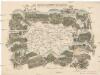
Das böhmisch-sächsische Grenzgebirge
Lužická Nisa-oblast lith. Kunstanstalt von Ed. Strache
Landkreis Böhm[isch] Leipa
1 : 75000 Protektorát Čechy a Morava Dienststelle für Raumordnung und Landesplanung beim Regierungspräsidenten
Varnsdorf
1 : 75000 Cvikov (Česko : oblast) Vojenský zeměpisný ústav
Special Karte des politischen Amtsbezirkes Böhm. Leipa
Česká Lípa-oblast (Česko) Jos. Hamann
Rumburg und Warnsdorf
1 : 75000 Rumburk (Česko : oblast) Lampe K. u. k. militär-geographisches Institut
Rumburg und Warnsdorf
1 : 75000 Rumburk (Česko : oblast) Lampe K. u. k. Militärgeographisches Institut
Rumburg und Warnsdorf
1 : 75000 Rumburk (Česko : oblast) K. u. k. Militärgeographisches Institut
III. vojenské mapování 3653
1 : 75000
Varnsdorf
1 : 75000 Varnsdorf-oblast (Česko) Vojenský zeměpisný ústav