Maps of Postoloprty

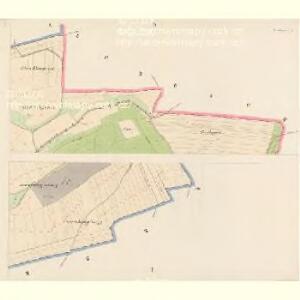
Postelberg (Postoloprt) - c6040-1-002 - Kaiserpflichtexemplar der Landkarten des stabilen Katasters
1 : 2880
Postelberg (Postoloprt) - c6040-1-001 - Kaiserpflichtexemplar der Landkarten des stabilen Katasters
1 : 2880
Postelberg (Postoloprt) - c6040-1-003 - Kaiserpflichtexemplar der Landkarten des stabilen Katasters
1 : 2880
Postelberg (Postoloprt) - c6040-1-004 - Kaiserpflichtexemplar der Landkarten des stabilen Katasters
1 : 2880
Postelberg (Postoloprt) - c6040-1-005 - Kaiserpflichtexemplar der Landkarten des stabilen Katasters
1 : 2880
Postelberg (Postoloprt) - c6040-1-006 - Kaiserpflichtexemplar der Landkarten des stabilen Katasters
1 : 2880
Priesen (Brezno) - c0593-1-003 - Kaiserpflichtexemplar der Landkarten des stabilen Katasters
1 : 2880
Priesen (Brezno) - c0593-1-004 - Kaiserpflichtexemplar der Landkarten des stabilen Katasters
1 : 2880
Priesen (Brezno) - c0593-1-001 - Kaiserpflichtexemplar der Landkarten des stabilen Katasters
1 : 2880
Priesen (Brezno) - c0593-1-002 - Kaiserpflichtexemplar der Landkarten des stabilen Katasters
1 : 2880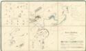
Polesní mapa polesí Postoloprty, druhý exemplář 1

Porostní mapa polesí Postoloprty, druhý exemplář 1
1 : 10000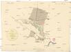
Plan über die Lage und Umgebung des Spielhügels bey Ferbenz
1 : 11600 Postoloprty-oblast (Česko) Gassauer
Skupitz - c6981-1-003 - Kaiserpflichtexemplar der Landkarten des stabilen Katasters
1 : 2880
Skupitz - c6981-1-001 - Kaiserpflichtexemplar der Landkarten des stabilen Katasters
1 : 2880
Skupitz - c6981-1-002 - Kaiserpflichtexemplar der Landkarten des stabilen Katasters
1 : 2880
Ferbenz - c6637-1-003 - Kaiserpflichtexemplar der Landkarten des stabilen Katasters
1 : 2880
Ferbenz - c6637-1-002 - Kaiserpflichtexemplar der Landkarten des stabilen Katasters
1 : 2880
Ferbenz - c6637-1-001 - Kaiserpflichtexemplar der Landkarten des stabilen Katasters
1 : 2880
Lewanitz - c3905-1-003 - Kaiserpflichtexemplar der Landkarten des stabilen Katasters
1 : 2880
Lewanitz - c3905-1-001 - Kaiserpflichtexemplar der Landkarten des stabilen Katasters
1 : 2880
Lewanitz - c3905-1-002 - Kaiserpflichtexemplar der Landkarten des stabilen Katasters
1 : 2880
Ferbka - c8835-1-001 - Kaiserpflichtexemplar der Landkarten des stabilen Katasters
1 : 2880
Ferbka - c8835-1-002 - Kaiserpflichtexemplar der Landkarten des stabilen Katasters
1 : 2880
Semenkowitz - c6827-1-003 - Kaiserpflichtexemplar der Landkarten des stabilen Katasters
1 : 2880
Semenkowitz - c6827-1-001 - Kaiserpflichtexemplar der Landkarten des stabilen Katasters
1 : 2880
Semenkowitz - c6827-1-002 - Kaiserpflichtexemplar der Landkarten des stabilen Katasters
1 : 2880
Karte des Bezirkes Postelberg
1 : 36000 Postoloprty-oblast (Česko) Hollmann, Victor Josef Mecséry de Tsóor, Karl Johann Friedrich Selner
Gradkartenblatt
1 : 25000 Postoloprty-oblast (Česko) Bellschan, Anton