Maps of Polepy

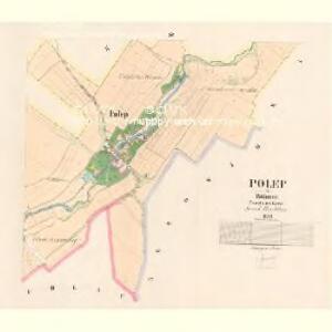
Polep - c5978-1-001 - Kaiserpflichtexemplar der Landkarten des stabilen Katasters
1 : 2880
Polep - c5978-1-002 - Kaiserpflichtexemplar der Landkarten des stabilen Katasters
1 : 2880
Petschkau (Peczky) - c0926-1-005 - Kaiserpflichtexemplar der Landkarten des stabilen Katasters
1 : 2880
Petschkau (Peczky) - c0926-1-004 - Kaiserpflichtexemplar der Landkarten des stabilen Katasters
1 : 2880
Petschkau (Peczky) - c0926-1-002 - Kaiserpflichtexemplar der Landkarten des stabilen Katasters
1 : 2880
Petschkau (Peczky) - c0926-1-003 - Kaiserpflichtexemplar der Landkarten des stabilen Katasters
1 : 2880
Petschkau (Peczky) - c0926-1-001 - Kaiserpflichtexemplar der Landkarten des stabilen Katasters
1 : 2880
Nebowid (Nebowidy) - c4980-1-001 - Kaiserpflichtexemplar der Landkarten des stabilen Katasters
1 : 2880
Nebowid (Nebowidy) - c4980-1-004 - Kaiserpflichtexemplar der Landkarten des stabilen Katasters
1 : 2880
Nebowid (Nebowidy) - c4980-1-003 - Kaiserpflichtexemplar der Landkarten des stabilen Katasters
1 : 2880
Nebowid (Nebowidy) - c4980-1-002 - Kaiserpflichtexemplar der Landkarten des stabilen Katasters
1 : 2880
Paschinka (Passinka) - c5650-1-002 - Kaiserpflichtexemplar der Landkarten des stabilen Katasters
1 : 2880
Paschinka (Passinka) - c5650-1-001 - Kaiserpflichtexemplar der Landkarten des stabilen Katasters
1 : 2880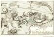
Plan der Bataille welche den 18. Junÿ 1757 von der Kayserlich Königlich-Ungarischen und Königlich Preussischen Armée in Böhmen ohnweit Planian und Collin beÿ Chotzemitz geliefert worden
Mollova mapová sbírka Fridrich, Jacob Andreas Friedrich, Jacob Andreas

Plan der Bataille bey Kollin den 18ten Junius 1757
Kolín (Česko : oblast)
Eisenbahn Karte Wien-Dresden, Ollmütz-Trübau
1 : 72000 Blatt 11 Minarzik, Anselm J. Rauh
Podrobné mapy zemí Koruny české v měřítku 1:75.000 a mapa vzdáleností všech míst při silnici ležících
1 : 75000 Chlumec nad Cidlinou-oblast (Česko) Bělohlav, Josef Kučera, Karel F. Topič
Kolínský vikariát
Kolín-oblast (Česko)
Kutná Hora a okolí
1 : 75000 Kutná Hora (Česko : oblast) Vojenský zeměpisný ústav
Soubor přehledných map pro plánování a statistiku: 3954 – Kolín

Politický okres Kolín
1 : 100000 Kolín (Česko) Josef Richard Vilímek
Politický okres Kolín
1 : 100000 Kolín (Česko : okres : 1960-) Kratochvíl, M. Josef Richard Vilímek
Politický okres Kolín 4
Vilímek, Josef Richard
Vilímkovy místopisné mapy zemí Koruny české
1 : 100000 Kolín (Česko : oblast) Srp, Jan Jos. R. Vilímek
Podrobná mapa Království českého
1 : 100000 Kolín (Česko : oblast) Srp, Jan Jaroslav Bursík
Hejtmanství kolínské
1 : 150000 Kolín-oblast (Česko) Tůma, Josef
Politický okres Kutná Hora
1 : 100000 Kutná Hora (Česko : okres : 1960-) Kratochvíl, M. Josef Richard Vilímek
Indikační skica mapy stabilního katastru pro město Přelouč VI.
1 : 2880