Maps of Ostružno

Wostruschno - c5571-1-002 - Kaiserpflichtexemplar der Landkarten des stabilen Katasters
1 : 2880
Wostruschno - c5571-1-003 - Kaiserpflichtexemplar der Landkarten des stabilen Katasters
1 : 2880
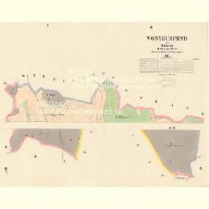
Wostruschno - c5571-1-001 - Kaiserpflichtexemplar der Landkarten des stabilen Katasters
1 : 2880
Březina - c0575-1-002 - Kaiserpflichtexemplar der Landkarten des stabilen Katasters
1 : 2880
Březina - c0575-1-001 - Kaiserpflichtexemplar der Landkarten des stabilen Katasters
1 : 2880
Březina - c0575-1-003 - Kaiserpflichtexemplar der Landkarten des stabilen Katasters
1 : 2880
Woharitz - c5381-1-002 - Kaiserpflichtexemplar der Landkarten des stabilen Katasters
1 : 2880
Woharitz - c5381-1-001 - Kaiserpflichtexemplar der Landkarten des stabilen Katasters
1 : 2880
Woharitz - c5381-1-003 - Kaiserpflichtexemplar der Landkarten des stabilen Katasters
1 : 2880
Wohawetsch - c5382-1-001 - Kaiserpflichtexemplar der Landkarten des stabilen Katasters
1 : 2880
Mapa porostů revírů Křelina, Lázně, Prachov a Střeleč
1 : 14400 Křelina (Bukvice, Jičín, Česko) Krýš, Vilém
Prachovské skály u Jičína
1 : 10000 Prachovské skály (Česko) Lepař, Zdeněk Filipovský, Karel Jan Pašek
Plan des Gefechtsfeldes von Gitschin den 29ten Juni 1866
1 : 25000 Jičín-oblast (Česko) Leithold, von Beelitz
Plan des Gefechtsfeldes von Gitschin den 29ten Juni 1866
1 : 25000 Jičín-oblast (Česko) Leithold, von Beelitz
Plan zum Treffen bei Jičin 29. Juni 1866
1 : 28880 Jičín (Česko) Ditfurth, Moritz von des K. u. k. Militärgeographischen Instituts
Plan zum Treffen bei Jičin 29. Juni 1866
1 : 28500 Jičín-oblast (Česko)
Jitschin (Jičín)

Mapa Prachovských skal u Jičína
1 : 10000 Jičín (Česko : oblast) Klub československých turistů
Revier Křelina
1 : 7200 Křelina (Bukvice, Jičín, Česko)
Nadslaw - c4940-1-001 - Kaiserpflichtexemplar der Landkarten des stabilen Katasters
1 : 2880
Nadslaw - c4940-1-004 - Kaiserpflichtexemplar der Landkarten des stabilen Katasters
1 : 2880
Nadslaw - c4940-1-003 - Kaiserpflichtexemplar der Landkarten des stabilen Katasters
1 : 2880
Nadslaw - c4940-1-002 - Kaiserpflichtexemplar der Landkarten des stabilen Katasters
1 : 2880
Podhrad - c5893-1-001 - Kaiserpflichtexemplar der Landkarten des stabilen Katasters
1 : 2880
Podhrad - c5893-1-003 - Kaiserpflichtexemplar der Landkarten des stabilen Katasters
1 : 2880
Podhrad - c5893-1-002 - Kaiserpflichtexemplar der Landkarten des stabilen Katasters
1 : 2880
Podhrad - c5893-1-004 - Kaiserpflichtexemplar der Landkarten des stabilen Katasters
1 : 2880
Ober Lochow (Lochow Hořenj) - c2091-1-004 - Kaiserpflichtexemplar der Landkarten des stabilen Katasters
1 : 2880
Ober Lochow (Lochow Hořenj) - c2091-1-002 - Kaiserpflichtexemplar der Landkarten des stabilen Katasters
1 : 2880
Ober Lochow (Lochow Hořenj) - c2091-1-003 - Kaiserpflichtexemplar der Landkarten des stabilen Katasters
1 : 2880