Maps of Rožmitál pod Třemšínem

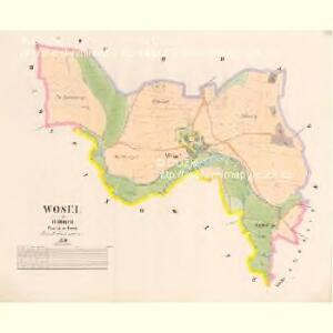
Wosel - c5539-1-001 - Kaiserpflichtexemplar der Landkarten des stabilen Katasters
1 : 2880
Chrast - c2627-1-002 - Kaiserpflichtexemplar der Landkarten des stabilen Katasters
1 : 2880
Chrast - c2627-1-004 - Kaiserpflichtexemplar der Landkarten des stabilen Katasters
1 : 2880
Chrast - c2627-1-001 - Kaiserpflichtexemplar der Landkarten des stabilen Katasters
1 : 2880
Chrast - c2627-1-003 - Kaiserpflichtexemplar der Landkarten des stabilen Katasters
1 : 2880
Pinowitz - c5854-1-004 - Kaiserpflichtexemplar der Landkarten des stabilen Katasters
1 : 2880
Pinowitz - c5854-1-001 - Kaiserpflichtexemplar der Landkarten des stabilen Katasters
1 : 2880
Pinowitz - c5854-1-003 - Kaiserpflichtexemplar der Landkarten des stabilen Katasters
1 : 2880
Pinowitz - c5854-1-005 - Kaiserpflichtexemplar der Landkarten des stabilen Katasters
1 : 2880
Pinowitz - c5854-1-006 - Kaiserpflichtexemplar der Landkarten des stabilen Katasters
1 : 2880
Pinowitz - c5854-1-002 - Kaiserpflichtexemplar der Landkarten des stabilen Katasters
1 : 2880
Mapa porostů panství Tochovice, Březnice a Rožmitála
1 : 17280 Březnice (Příbram, Česko) Schrantz, Fr.
General-Mape der Herrschaft Březnic
1 : 34560 Březnice (Příbram, Česko : oblast)
III. vojenské mapování 4152/3
1 : 25000
Gradkartenblatt
1 : 25000 Březnice-oblast (Příbram, Česko) Siglitz, Franz
Přehlední [sic] mapa velkostatků Tochovice, Břežnice Rožmitál
1 : 50000 Březnice (Příbram, Česko) Schrantz, Fr.
Plan der Herrschaft Rožmital im Prachiner Kreise


Přehlední [sic] mapa velkostatek Rožmital
1 : 50000 Rožmitál pod Třemšínem-oblast (Česko)
Soubor map okresů Pražského kraje

Mapa okresu Příbramského v Pražském kraji

Podrobné mapy zemí Koruny české v měřítku 1:75.000 a mapa vzdáleností všech míst při silnici ležících
1 : 75000 Dobříš (Česko : oblast) Bělohlav, Josef F. Topič
Přibram und Mirowitz
1 : 75000 Mirovice (Česko : oblast) Schill K. u. k. Militärgeographisches Institut
Přibram und Mirowitz
1 : 75000 Mirovice (Česko : oblast) K. u. k. Militärgeographisches Institut
III. vojenské mapování 4152
1 : 75000
Mapy plánování ČSR

Příbram
1 : 75000 Příbram (Česko : oblast) Vojenský zeměpisný ústav
Příbram
1 : 75000 Příbram-oblast (Česko) Vojenský zeměpisný ústav
Příbram
1 : 75000 Příbram (Česko : oblast) Vojenský zeměpisný ústav