Maps of Mostowice

Kronstadt (Kunstat) - c5510-2-001 - Kaiserpflichtexemplar der Landkarten des stabilen Katasters
1 : 2880
Kronstadt (Kunstat) - c5510-2-004 - Kaiserpflichtexemplar der Landkarten des stabilen Katasters
1 : 2880
Kronstadt (Kunstat) - c5510-2-003 - Kaiserpflichtexemplar der Landkarten des stabilen Katasters
1 : 2880
Kronstadt (Kunstat) - c5510-2-005 - Kaiserpflichtexemplar der Landkarten des stabilen Katasters
1 : 2880
Kronstadt (Kunstat) - c5510-2-002 - Kaiserpflichtexemplar der Landkarten des stabilen Katasters
1 : 2880
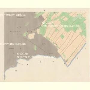
Schwarzwasser (Černávoda) - c0875-1-001 - Kaiserpflichtexemplar der Landkarten des stabilen Katasters
1 : 2880
Schwarzwasser (Černávoda) - c0875-1-002 - Kaiserpflichtexemplar der Landkarten des stabilen Katasters
1 : 2880
Schwarzwasser (Černávoda) - c0875-1-003 - Kaiserpflichtexemplar der Landkarten des stabilen Katasters
1 : 2880
Schwarzwasser (Černávoda) - c0875-1-005 - Kaiserpflichtexemplar der Landkarten des stabilen Katasters
1 : 2880
Schwarzwasser (Černávoda) - c0875-1-004 - Kaiserpflichtexemplar der Landkarten des stabilen Katasters
1 : 2880
Meßtischblatt 5764 : Langenbrück, 1936
1 : 250000 Langenbrück. - Aufn. 1936. - 1:25000. - [Berlin]: Reichsamt für Landesaufnahme, 1936. - 1 Kt.
Meßtischblatt 3339 : Langenbrück, 1883
1 : 250000 Langenbrück. - Aufn. 1882. - 1:25000. - [Berlin]: Kgl. Preuss. Landesaufnahme, 1883. - 1 Kt.
III. vojenské mapování 3857/1-3
1 : 25000
[Kartenblatt]
1 : 25000 Bystřické hory (Polsko) Reichsamt für Landesaufnahme
Klein Stiebnitz (Mala Stjbnice) - c9236-3-006 - Kaiserpflichtexemplar der Landkarten des stabilen Katasters
1 : 2880
Klein Stiebnitz (Mala Stjbnice) - c9236-3-004 - Kaiserpflichtexemplar der Landkarten des stabilen Katasters
1 : 2880
Klein Stiebnitz (Mala Stjbnice) - c9236-3-005 - Kaiserpflichtexemplar der Landkarten des stabilen Katasters
1 : 2880
Klein Stiebnitz (Mala Stjbnice) - c9236-3-007 - Kaiserpflichtexemplar der Landkarten des stabilen Katasters
1 : 2880
Klein Stiebnitz (Mala Stjbnice) - c9236-3-002 - Kaiserpflichtexemplar der Landkarten des stabilen Katasters
1 : 2880
Klein Stiebnitz (Mala Stjbnice) - c9236-3-003 - Kaiserpflichtexemplar der Landkarten des stabilen Katasters
1 : 2880
Klein Stiebnitz (Mala Stjbnice) - c9236-3-001 - Kaiserpflichtexemplar der Landkarten des stabilen Katasters
1 : 2880
Kerndorf - c2731-3-002 - Kaiserpflichtexemplar der Landkarten des stabilen Katasters
1 : 2880
Kerndorf - c2731-3-003 - Kaiserpflichtexemplar der Landkarten des stabilen Katasters
1 : 2880
Kerndorf - c2731-3-001 - Kaiserpflichtexemplar der Landkarten des stabilen Katasters
1 : 2880
Mapa svěřenských statků Rychnova a Černíkovic
1 : 43200 Rychnov nad Kněžnou-oblast (Česko) Barth, A.
Gradabtheilung 50/51 der Breite 34/35 der Länge
Kořistka, Karel František Edvard
[Neustadt und Umgebung]
1 : 144000 Nové Město nad Metují (Česko : oblast)
III. vojenské mapování 3857
1 : 75000