Maps of Nová Ves I

Neudorf (Nowawes) - c5225-1-001 - Kaiserpflichtexemplar der Landkarten des stabilen Katasters
1 : 2880
Neudorf (Nowawes) - c5225-1-004 - Kaiserpflichtexemplar der Landkarten des stabilen Katasters
1 : 2880
Neudorf (Nowawes) - c5225-1-002 - Kaiserpflichtexemplar der Landkarten des stabilen Katasters
1 : 2880
Neudorf (Nowawes) - c5225-1-007 - Kaiserpflichtexemplar der Landkarten des stabilen Katasters
1 : 2880
Neudorf (Nowawes) - c5225-1-003 - Kaiserpflichtexemplar der Landkarten des stabilen Katasters
1 : 2880
Neudorf (Nowawes) - c5225-1-005 - Kaiserpflichtexemplar der Landkarten des stabilen Katasters
1 : 2880
Neudorf (Nowawes) - c5225-1-006 - Kaiserpflichtexemplar der Landkarten des stabilen Katasters
1 : 2880
Messtisch-Aufnahme von Juni und Juli 1876 der Elbepartie nächst Weltrub
1 : 8700 Labe (Česko a Německo) Mayr, Josef Fiala, Franz
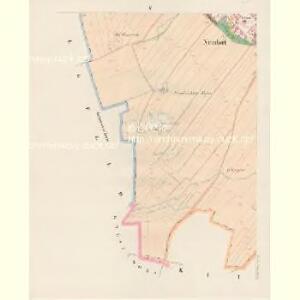
Hradischko (Hradissko) - c2320-1-001 - Kaiserpflichtexemplar der Landkarten des stabilen Katasters
1 : 2880
Hradischko (Hradissko) - c2320-1-002 - Kaiserpflichtexemplar der Landkarten des stabilen Katasters
1 : 2880
Weltrub (Weltruby) - c8473-1-002 - Kaiserpflichtexemplar der Landkarten des stabilen Katasters
1 : 2880
Weltrub (Weltruby) - c8473-1-001 - Kaiserpflichtexemplar der Landkarten des stabilen Katasters
1 : 2880
Weltrub (Weltruby) - c8473-1-003 - Kaiserpflichtexemplar der Landkarten des stabilen Katasters
1 : 2880
Weltrub (Weltruby) - c8473-1-004 - Kaiserpflichtexemplar der Landkarten des stabilen Katasters
1 : 2880
Siegfeld - c8622-1-001 - Kaiserpflichtexemplar der Landkarten des stabilen Katasters
1 : 2880
Siegfeld - c8622-1-002 - Kaiserpflichtexemplar der Landkarten des stabilen Katasters
1 : 2880
Kuttlirz (Kuttliř) - c3734-1-002 - Kaiserpflichtexemplar der Landkarten des stabilen Katasters
1 : 2880
Kuttlirz (Kuttliř) - c3734-1-001 - Kaiserpflichtexemplar der Landkarten des stabilen Katasters
1 : 2880
Labe u Veltrub

III. vojenské mapování 3954/4
1 : 25000
III. vojenské mapování 3954/4
1 : 25000
Gradkartenblatt
1 : 25000 Kolín-oblast (Česko) Czechák, Carl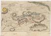
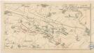
Plan der Bataille ohnweit Planian und Kaurzim bey Chotzemitz welche den 18. Juny 1757 zwischen denen kayserl. königl. hung. böhmisch. und königlich preusischen Arméen vorgefallen, allwo nach 7. mahligem Angriff, die Preusische sich retiriret, und die k. k. das Feld beh[au]ptet
Kolín-oblast (Česko)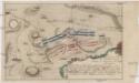
Accurater Plan der Bataille ohnweit Planian und Kaurzim bey dem Dorff Chotzemitz
Kolín-oblast (Česko)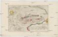
Accurater Plan der Bataille ohnweit Planian und Kaurzim bey dem Dorffe Chotzemitz
Kolín-oblast (Česko)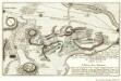
Plan der Bataille welche den 18. Junÿ 1757 von der Kayserlich Königlich-Ungarischen und Königlich Preussischen Armée in Böhmen ohnweit Planian und Collin beÿ Chotzemitz geliefert worden
Mollova mapová sbírka Fridrich, Jacob Andreas Friedrich, Jacob Andreas
Plan der Bataille bey Collin so zwischen der kayser. könig. Armée unter Commando sr. Excellentz des Herren General Feld-Marschalls Leopold Graffen v. Daun und der könig. preussischen Armée, unter Com[m]ando ihro Maj. des Königs, den 18ten Junii 1757 vorgefallen.
Kolín-oblast (Česko) Erdmann, F. G. Mikolášek, Antonín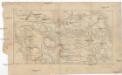
Bojiště u Kolína v podobě před sto lety
1 : 55000 Kolín-oblast (Česko)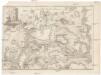
Schlacht bey Kollin in Boheim den 18ten Jun. 1757
1 : 35000 Kolín (Česko : oblast) Oesfeld, Karl Ludwig von