Maps of Jenišovice

Klein Rohosetz (Malegrohosec) - c4459-1-002 - Kaiserpflichtexemplar der Landkarten des stabilen Katasters
1 : 2880
Klein Rohosetz (Malegrohosec) - c4459-1-001 - Kaiserpflichtexemplar der Landkarten des stabilen Katasters
1 : 2880
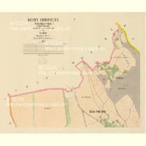
Wohrasenitz (Wohraženice) - c5390-1-003 - Kaiserpflichtexemplar der Landkarten des stabilen Katasters
1 : 2880
Wohrasenitz (Wohraženice) - c5390-1-001 - Kaiserpflichtexemplar der Landkarten des stabilen Katasters
1 : 2880
Wohrasenitz (Wohraženice) - c5390-1-004 - Kaiserpflichtexemplar der Landkarten des stabilen Katasters
1 : 2880
Wohrasenitz (Wohraženice) - c5390-1-002 - Kaiserpflichtexemplar der Landkarten des stabilen Katasters
1 : 2880
Jentschowitz (Genčowice) - c2839-1-003 - Kaiserpflichtexemplar der Landkarten des stabilen Katasters
1 : 2880
Jentschowitz (Genčowice) - c2839-1-002 - Kaiserpflichtexemplar der Landkarten des stabilen Katasters
1 : 2880
Jentschowitz (Genčowice) - c2839-1-001 - Kaiserpflichtexemplar der Landkarten des stabilen Katasters
1 : 2880
Polohopis města Turnova

Borek - c5472-2-002 - Kaiserpflichtexemplar der Landkarten des stabilen Katasters
1 : 2880
Borek - c5472-2-003 - Kaiserpflichtexemplar der Landkarten des stabilen Katasters
1 : 2880
Borek - c5472-2-001 - Kaiserpflichtexemplar der Landkarten des stabilen Katasters
1 : 2880
Bukowina - c1232-2-001 - Kaiserpflichtexemplar der Landkarten des stabilen Katasters
1 : 2880
Bukowina - c1232-2-002 - Kaiserpflichtexemplar der Landkarten des stabilen Katasters
1 : 2880

III. vojenské mapování 3754/4
1 : 25000


Podrobné mapy zemí Koruny české v měřítku 1:75.000 a mapa vzdáleností všech míst při silnici ležících - Jablonec - Roketnice - Žel. Brod. Průvodce statisticko-historický po všech místech na těchto mapách uvedených a rejstřík věcný názvů hor, potoků, řek, rybníků atd. Sešit 11. List 78,
1 : 75000
Mapa politického a školního okresu turnovského

Mapa politického a školního okresu turnovského
1 : 100000 Turnov-oblast (Česko) Učitelská jednota okresu turnovského
Turnov a okolí
1 : 75000 Turnov (Česko : oblast) Vojenský zeměpisný ústav
Turnov
1 : 75000 Turnov (Česko : oblast) Vojenský zeměpisný ústav
III. vojenské mapování 3754
1 : 75000
Jablonec n. N. a okolí
1 : 75000 Jablonec nad Nisou (Česko : oblast) Vojenský zeměpisný ústav
Turnau
1 : 75000 Mnichovo Hradiště (Česko : oblast) Fitz K. u. k. Militärgeographisches Institut
Turnau
1 : 75000 Mnichovo Hradiště (Česko : oblast) Fitz K. u. k. Militärgeographisches Institut
Turnau
1 : 75000 Turnov (Česko : oblast) K. u. k. Militärgeographisches Institut