Maps of Žirovnice

Litkowitz - c4162-1-001 - Kaiserpflichtexemplar der Landkarten des stabilen Katasters
1 : 2880
Litkowitz - c4162-1-002 - Kaiserpflichtexemplar der Landkarten des stabilen Katasters
1 : 2880
Strana - c7384-1-005 - Kaiserpflichtexemplar der Landkarten des stabilen Katasters
1 : 2880
Strana - c7384-1-003 - Kaiserpflichtexemplar der Landkarten des stabilen Katasters
1 : 2880
Strana - c7384-1-001 - Kaiserpflichtexemplar der Landkarten des stabilen Katasters
1 : 2880
Strana - c7384-1-002 - Kaiserpflichtexemplar der Landkarten des stabilen Katasters
1 : 2880
Strana - c7384-1-004 - Kaiserpflichtexemplar der Landkarten des stabilen Katasters
1 : 2880
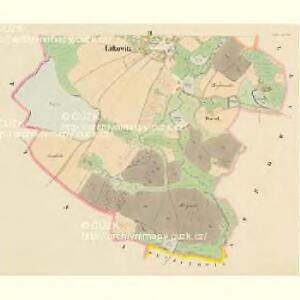
Stüttna - c7799-1-003 - Kaiserpflichtexemplar der Landkarten des stabilen Katasters
1 : 2880
Stüttna - c7799-1-002 - Kaiserpflichtexemplar der Landkarten des stabilen Katasters
1 : 2880
Stüttna - c7799-1-006 - Kaiserpflichtexemplar der Landkarten des stabilen Katasters
1 : 2880
Stüttna - c7799-1-001 - Kaiserpflichtexemplar der Landkarten des stabilen Katasters
1 : 2880
Stüttna - c7799-1-005 - Kaiserpflichtexemplar der Landkarten des stabilen Katasters
1 : 2880
Stüttna - c7799-1-004 - Kaiserpflichtexemplar der Landkarten des stabilen Katasters
1 : 2880


Podrobná mapa Království českého
1 : 100000 Jindřichův Hradec (Česko : oblast) Srp, Jan Jaroslav Bursík
Podrobná mapa Markrabství moravského a Vévodství slezského
1 : 100000 Jindřichův Hradec (Česko : oblast) Srp, Jan Jaroslav Bursík
Podrobná mapa Království českého, Markrabství moravského a Vévodství slezského
1 : 100000 Jindřichův Hradec (Česko : oblast) Srp, Jan Jos. R. Vilímek
Neuhaus.
from Spezialkarte der osterreichisch-ungarischen Monarchie.
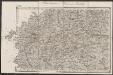
Special - Karte des Koenigreiches Boehmen

Kamenitz a./d. Linde (Bohmen).
from Spezialkarte der osterreichisch-ungarischen Monarchie.
II. vojenské mapování 31
1 : 144000
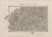
Generální mapa okresního hejtmanství Pelhřimovského
1 : 220000 Pelhřimov-oblast (Česko) Wagner, Jan Eduard F. Kytka
II. vojenské mapování 12
1 : 144000
Generální mapa okresních hejtmanství

Generální mapa okresních hejtmanství
II. vojenské mapování 12
1 : 144000
Generální mapa okresních hejtmanství

Generální mapa okresních hejtmanství