Maps of Kublov

Kublow - c3681-1-002 - Kaiserpflichtexemplar der Landkarten des stabilen Katasters
1 : 2880
Kublow - c3681-1-001 - Kaiserpflichtexemplar der Landkarten des stabilen Katasters
1 : 2880
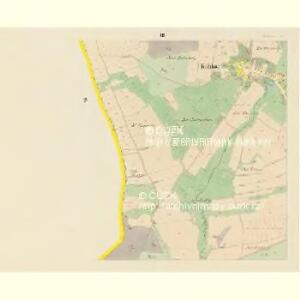
Kublow - c3681-1-004 - Kaiserpflichtexemplar der Landkarten des stabilen Katasters
1 : 2880
Kublow - c3681-1-003 - Kaiserpflichtexemplar der Landkarten des stabilen Katasters
1 : 2880
Braum - c0530-1-007 - Kaiserpflichtexemplar der Landkarten des stabilen Katasters
1 : 2880
Braum - c0530-1-008 - Kaiserpflichtexemplar der Landkarten des stabilen Katasters
1 : 2880
Braum - c0530-1-003 - Kaiserpflichtexemplar der Landkarten des stabilen Katasters
1 : 2880
Braum - c0530-1-009 - Kaiserpflichtexemplar der Landkarten des stabilen Katasters
1 : 2880
Braum - c0530-1-006 - Kaiserpflichtexemplar der Landkarten des stabilen Katasters
1 : 2880
Braum - c0530-1-013 - Kaiserpflichtexemplar der Landkarten des stabilen Katasters
1 : 2880
Braum - c0530-1-004 - Kaiserpflichtexemplar der Landkarten des stabilen Katasters
1 : 2880
Braum - c0530-1-012 - Kaiserpflichtexemplar der Landkarten des stabilen Katasters
1 : 2880
Braum - c0530-1-010 - Kaiserpflichtexemplar der Landkarten des stabilen Katasters
1 : 2880
Braum - c0530-1-014 - Kaiserpflichtexemplar der Landkarten des stabilen Katasters
1 : 2880
Braum - c0530-1-001 - Kaiserpflichtexemplar der Landkarten des stabilen Katasters
1 : 2880
Braum - c0530-1-011 - Kaiserpflichtexemplar der Landkarten des stabilen Katasters
1 : 2880
Braum - c0530-1-002 - Kaiserpflichtexemplar der Landkarten des stabilen Katasters
1 : 2880
Braum - c0530-1-005 - Kaiserpflichtexemplar der Landkarten des stabilen Katasters
1 : 2880
III. vojenské mapování 4052/1
1 : 25000
Gradkartenblatt
1 : 25000 Beroun-oblast (Česko) Böhm, Karl
III. vojenské mapování 4052/1
1 : 25000

Podrobné mapy zemí Koruny české v měřítku 1:75.000 a mapa vzdáleností všech míst při silnici ležících.. Průvodce statisticko-historický po všech místech na těchto mapách uvedených a rejstřík věcný názvů hor, potoků, řek, rybníků atd. Sešit 28. List 30,
1 : 75000
Uibersichts- und Bestandes-Karte des am rechten Ufer des Mies-Flusses gelegenen und zur Domaine Pürglitz gehörigen Waldcomplexes
1 : 70000 Křivoklát-oblast (Česko) Verlag des böhm. Forst-Vereines
Podrobná mapa okolí Pražského List III.

Karte des Gemeindegrenzen
Geologická mapa Československé republiky, list: Beroun - Hořovice (4052)
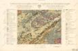
Geologická mapa Československé Republiky

Beraun und Hořowitz
1 : 75000 Beroun (Česko : oblast) Radler K. u. k. militär-geographisches Institut
Beraun und Hořowitz
1 : 75000 Beroun (Česko : oblast) Radler K. u. k. Militärgeographisches Institut