Maps of Krásná Hora nad Vltavou

Kraschowitz (Krassowic) - c3537-1-002 - Kaiserpflichtexemplar der Landkarten des stabilen Katasters
1 : 2880
Kraschowitz (Krassowic) - c3537-1-001 - Kaiserpflichtexemplar der Landkarten des stabilen Katasters
1 : 2880
Mokřiz - c4827-1-001 - Kaiserpflichtexemplar der Landkarten des stabilen Katasters
1 : 2880
Mokřiz - c4827-1-002 - Kaiserpflichtexemplar der Landkarten des stabilen Katasters
1 : 2880
Mokřiz - c4827-1-003 - Kaiserpflichtexemplar der Landkarten des stabilen Katasters
1 : 2880
Kuny - c3709-1-003 - Kaiserpflichtexemplar der Landkarten des stabilen Katasters
1 : 2880
Kuny - c3709-1-002 - Kaiserpflichtexemplar der Landkarten des stabilen Katasters
1 : 2880
Kuny - c3709-1-001 - Kaiserpflichtexemplar der Landkarten des stabilen Katasters
1 : 2880
Wletitz (Wletice) - c8683-1-003 - Kaiserpflichtexemplar der Landkarten des stabilen Katasters
1 : 2880
Wletitz (Wletice) - c8683-1-001 - Kaiserpflichtexemplar der Landkarten des stabilen Katasters
1 : 2880
Wletitz (Wletice) - c8683-1-002 - Kaiserpflichtexemplar der Landkarten des stabilen Katasters
1 : 2880
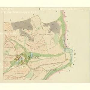
Radeschin (Radessin) - c6327-1-001 - Kaiserpflichtexemplar der Landkarten des stabilen Katasters
1 : 2880
Radeschin (Radessin) - c6327-1-002 - Kaiserpflichtexemplar der Landkarten des stabilen Katasters
1 : 2880
Mezyhorz - c4564-1-001 - Kaiserpflichtexemplar der Landkarten des stabilen Katasters
1 : 2880
Mezyhorz - c4564-1-002 - Kaiserpflichtexemplar der Landkarten des stabilen Katasters
1 : 2880
Tintschan (Tinčan) - c8144-1-001 - Kaiserpflichtexemplar der Landkarten des stabilen Katasters
1 : 2880
Tintschan (Tinčan) - c8144-1-002 - Kaiserpflichtexemplar der Landkarten des stabilen Katasters
1 : 2880
Gradkartenblatt
1 : 25000 Milešov-oblast (Příbram, Česko) Siglitz, Franz
III. vojenské mapování 4152/4
1 : 25000

Přehledná mapa obrysová velkostatku Orlíka pro vycházku České lesnické jednoty s vyznačením trasy vycházky v r. 1877 a v r. 1890, použitá k označení názvů lesních dílů 1
1 : 75600
Mapy plánování ČSR

Podrobné mapy zemí Koruny české v měřítku 1:75.000 a mapa vzdáleností všech míst při silnici ležících - Březnice - Mirotice - Orlík - Zvíkov. Průvodce statisticko-historický po všech místech na těchto mapách uvedených a rejstřík věcný názvů hor, potoků, řek, rybníků atd. Sešit 43. List 44,
1 : 75000
Přehledná mapa velkostatku Orlíka, Čimelic, Varvažova, Tochovic a přivtělených statků Bukovan, Zalužan, a Zbenic podle majetkového stavu z r. 1905/06 1
1 : 25000
Podrobné mapy zemí Koruny české v měřítku 1:75.000 a mapa vzdáleností všech míst při silnici ležících
1 : 75000 Dobříš (Česko : oblast) Bělohlav, Josef F. Topič
Plan der hochfürstlich Schwarzenbergischen Herrschaften Worlik und Klingenberg
1 : 41400 Bukovany (Příbram, Česko) Hertschl, Franz
Přehledná mapa panství Orlíka a přivtělených statků 1

Přibram und Mirowitz
1 : 75000 Mirovice (Česko : oblast) Schill K. u. k. Militärgeographisches Institut
Přibram und Mirowitz
1 : 75000 Mirovice (Česko : oblast) K. u. k. Militärgeographisches Institut