Maps of Dolní Hbity

Katzin - c2964-1-002 - Kaiserpflichtexemplar der Landkarten des stabilen Katasters
1 : 2880
Katzin - c2964-1-001 - Kaiserpflichtexemplar der Landkarten des stabilen Katasters
1 : 2880
Ober Hbitt (Horno Hbit) - c2044-1-002 - Kaiserpflichtexemplar der Landkarten des stabilen Katasters
1 : 2880
Ober Hbitt (Horno Hbit) - c2044-1-001 - Kaiserpflichtexemplar der Landkarten des stabilen Katasters
1 : 2880
Ober Hbitt (Horno Hbit) - c2044-1-004 - Kaiserpflichtexemplar der Landkarten des stabilen Katasters
1 : 2880
Ober Hbitt (Horno Hbit) - c2044-1-003 - Kaiserpflichtexemplar der Landkarten des stabilen Katasters
1 : 2880
Smolotell - c7083-1-001 - Kaiserpflichtexemplar der Landkarten des stabilen Katasters
1 : 2880
Smolotell - c7083-1-004 - Kaiserpflichtexemplar der Landkarten des stabilen Katasters
1 : 2880
Smolotell - c7083-1-002 - Kaiserpflichtexemplar der Landkarten des stabilen Katasters
1 : 2880
Smolotell - c7083-1-003 - Kaiserpflichtexemplar der Landkarten des stabilen Katasters
1 : 2880
Smolotell - c7083-1-006 - Kaiserpflichtexemplar der Landkarten des stabilen Katasters
1 : 2880
Smolotell - c7083-1-005 - Kaiserpflichtexemplar der Landkarten des stabilen Katasters
1 : 2880
Gradkartenblatt
1 : 25000 Kamýk nad Vltavou (Česko) Mörk, Wenzel von
III. vojenské mapování 4152/2
1 : 25000

Karte des Příbramer Bezirkes im Prager Kreise
1 : 70000 Příbram-oblast (Česko) Wagner, Jan Eduard Karl André
Karte des Příbramer Bezirkes im Prager Kreise
1 : 70000 Příbram-oblast (Česko) Wagner, Jan Eduard Karl André
Podrobné mapy zemí Koruny české v měřítku 1:75.000 a mapa vzdáleností všech míst při silnici ležících - Příbram - Dobříš. Průvodce statisticko-historický po všech místech na těchto mapách uvedených a rejstřík věcný názvů hor, potoků, řek, rybníků atd./ Sešit 10. List 43,
1 : 75000
Náčrty majetkové držby statků v okolí Orlíka a Zvíkova od Karla IV. do r. 1850 znázorňující historický vývoj panství orlického a okolních statků, vyhotovené M. Jakubičkou r. 1917 podle Sedláčkových historických mapek, list 5 1

Soubor map okresů Pražského kraje

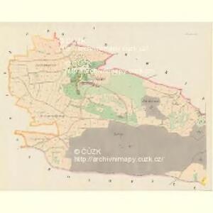
Mapa okresu Příbramského v Pražském kraji
Náčrt zemské silnice z Mirovic do Prahy v úseku Milín - Dobříš, s vyznačením návrhu na přeložení, zamýšleného r. 1710 1

Podrobné mapy zemí Koruny české v měřítku 1:75.000 a mapa vzdáleností všech míst při silnici ležících
1 : 75000 Dobříš (Česko : oblast) Bělohlav, Josef F. Topič
Přibram und Mirowitz
1 : 75000 Mirovice (Česko : oblast) Schill K. u. k. Militärgeographisches Institut
Přibram und Mirowitz
1 : 75000 Mirovice (Česko : oblast) K. u. k. Militärgeographisches Institut
III. vojenské mapování 4152
1 : 75000
Mapy plánování ČSR

Příbramer Vicariat
Příbram-oblast (Česko)
Příbram
1 : 75000 Příbram (Česko : oblast) Vojenský zeměpisný ústav
Příbram
1 : 75000 Příbram-oblast (Česko) Vojenský zeměpisný ústav