Maps of Bezvěrov

Kutsch - c2668-1-003 - Kaiserpflichtexemplar der Landkarten des stabilen Katasters
1 : 2880
Kutsch - c2668-1-001 - Kaiserpflichtexemplar der Landkarten des stabilen Katasters
1 : 2880
Kutsch - c2668-1-002 - Kaiserpflichtexemplar der Landkarten des stabilen Katasters
1 : 2880
Unterjamny - c1301-1-001 - Kaiserpflichtexemplar der Landkarten des stabilen Katasters
1 : 2880
Unterjamny - c1301-1-005 - Kaiserpflichtexemplar der Landkarten des stabilen Katasters
1 : 2880
Unterjamny - c1301-1-003 - Kaiserpflichtexemplar der Landkarten des stabilen Katasters
1 : 2880
Unterjamny - c1301-1-002 - Kaiserpflichtexemplar der Landkarten des stabilen Katasters
1 : 2880
Unterjamny - c1301-1-004 - Kaiserpflichtexemplar der Landkarten des stabilen Katasters
1 : 2880
Tschisotin (Czistolin) - c0996-1-001 - Kaiserpflichtexemplar der Landkarten des stabilen Katasters
1 : 2880
Tschisotin (Czistolin) - c0996-1-002 - Kaiserpflichtexemplar der Landkarten des stabilen Katasters
1 : 2880
Kamenahora - c3015-1-004 - Kaiserpflichtexemplar der Landkarten des stabilen Katasters
1 : 2880
Kamenahora - c3015-1-002 - Kaiserpflichtexemplar der Landkarten des stabilen Katasters
1 : 2880
Kamenahora - c3015-1-001 - Kaiserpflichtexemplar der Landkarten des stabilen Katasters
1 : 2880
Kamenahora - c3015-1-003 - Kaiserpflichtexemplar der Landkarten des stabilen Katasters
1 : 2880
Krasch (Krocze) - c3534-1-001 - Kaiserpflichtexemplar der Landkarten des stabilen Katasters
1 : 2880
Krasch (Krocze) - c3534-1-003 - Kaiserpflichtexemplar der Landkarten des stabilen Katasters
1 : 2880
Krasch (Krocze) - c3534-1-002 - Kaiserpflichtexemplar der Landkarten des stabilen Katasters
1 : 2880

Teusinger Vikariat
Toužim-oblast (Česko)
III. vojenské mapování 4050
1 : 75000
Město Teplá
1 : 75000 Teplá (Cheb, Česko : oblast) Vojenský zeměpisný ústav
Město Teplá
1 : 75000 Teplá-oblast (Cheb, Česko) Vojenský zeměpisný ústav
Tepl und Tuschkau
1 : 75000 Město Touškov (Česko : oblast) Bloschitz, Rudolf K. u. k. Militärgeographisches Institut
Tepl und Tuschkau
1 : 75000 Město Touškov-oblast (Česko) K. u. k. Militärgeographisches Institut
Teplá
1 : 75000 Bezdružice (Česko : oblast) Vojenský zeměpisný ústav
Tepl und Tuschkau.
from Spezialkarte der osterreichisch-ungarischen Monarchie.
Karlsbad und Luditz.
from Spezialkarte der osterreichisch-ungarischen Monarchie.
II. vojenské mapování 12
1 : 144000
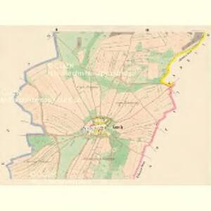
Generalkarte der Bezirkshauptmannschaft Karlsbad
1 : 220000 Karlovy Vary-oblast (Česko) Wagner, Jan Eduard Mareš, František F. Kytka
Generalkarte der Bezirkshauptmannschaft Karlsbad
1 : 220000 Karlovy Vary-oblast (Česko) Wagner, Jan Eduard F. Kytka