Maps of Vavřinec

Chmelischt (Chmelisst) - c2535-1-002 - Kaiserpflichtexemplar der Landkarten des stabilen Katasters
1 : 2880
Chmelischt (Chmelisst) - c2535-1-001 - Kaiserpflichtexemplar der Landkarten des stabilen Katasters
1 : 2880
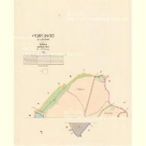
Wawrzinetz (Wawřinec) - c8336-1-003 - Kaiserpflichtexemplar der Landkarten des stabilen Katasters
1 : 2880
Wawrzinetz (Wawřinec) - c8336-1-002 - Kaiserpflichtexemplar der Landkarten des stabilen Katasters
1 : 2880
Wawrzinetz (Wawřinec) - c8336-1-001 - Kaiserpflichtexemplar der Landkarten des stabilen Katasters
1 : 2880
Žižow - c9452-1-002 - Kaiserpflichtexemplar der Landkarten des stabilen Katasters
1 : 2880
Žižow - c9452-1-001 - Kaiserpflichtexemplar der Landkarten des stabilen Katasters
1 : 2880
Kohljanowitz (Uhlijřský-Janowice) - c8184-1-003 - Kaiserpflichtexemplar der Landkarten des stabilen Katasters
1 : 2880
Kohljanowitz (Uhlijřský-Janowice) - c8184-1-005 - Kaiserpflichtexemplar der Landkarten des stabilen Katasters
1 : 2880
Kohljanowitz (Uhlijřský-Janowice) - c8184-1-004 - Kaiserpflichtexemplar der Landkarten des stabilen Katasters
1 : 2880
Kohljanowitz (Uhlijřský-Janowice) - c8184-1-002 - Kaiserpflichtexemplar der Landkarten des stabilen Katasters
1 : 2880
Kohljanowitz (Uhlijřský-Janowice) - c8184-1-001 - Kaiserpflichtexemplar der Landkarten des stabilen Katasters
1 : 2880

Mapa přehledná a mapa porostů knížete Jana z Liechtensteinů Rataje Hražené nad Sázavou

Gradkartenblatt
1 : 25000 Zásmuky-oblast (Česko) Czechák, Carl
III. vojenské mapování 4054/1
1 : 25000
III. vojenské mapování 4054/1
1 : 25000
Gradkartenblatt
1 : 25000 Kutná Hora-oblast (Česko) Czechák, Carl
Okres kouřímský [sic]
1 : 37000 Kouřim-oblast (Česko)
Podrobné mapy zemí Koruny české v měřítku 1:75.000 a mapa vzdáleností všech míst při silnici ležících - Kostelec n/Černými Lesy - Český Šternberk. Průvodce statisticko-historický po všech místech na těchto mapách uvedených a rejstřík věcný názvů hor, potoků, řek, rybníků atd. Sešit 16. List 69,
1 : 75000
Podrobné mapy zemí Koruny české v měřítku 1:75.000 a mapa vzdáleností všech míst při silnici ležících
1 : 75000 Kostelec nad Černými lesy (Česko : oblast) Bělohlav, Josef F. Topič
Mnichowitzer Vicariat
Mnichovice (Benešov, Česko)
Kutná Hora
1 : 75000 Kutná Hora (Česko : oblast) Vojenský zeměpisný ústav
Kuttenberg und Kohljanowitz
1 : 75000 Kutná Hora (Česko : oblast) Kotrtsch K. u. k. militär-geographisches Institut
Kuttenberg und Kohljanowitz
1 : 75000 Kutná Hora (Česko : oblast) Kotrtsch K. u. k. Militärgeographisches Institut
Kuttenberg und Kohljanowitz
1 : 75000 Kutná Hora (Česko : oblast) K. u. k. Militärgeographisches Institut
Mapy plánování ČSR

III. vojenské mapování 4054
1 : 75000
Karte des Gemeindegrenzen