Maps of Neustupov

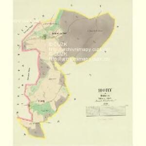
Hory - c2199-1-001 - Kaiserpflichtexemplar der Landkarten des stabilen Katasters
1 : 2880
Neustupow - c5091-1-001 - Kaiserpflichtexemplar der Landkarten des stabilen Katasters
1 : 2880
Neustupow - c5091-1-002 - Kaiserpflichtexemplar der Landkarten des stabilen Katasters
1 : 2880
Neustupow - c5091-1-006 - Kaiserpflichtexemplar der Landkarten des stabilen Katasters
1 : 2880
Neustupow - c5091-1-004 - Kaiserpflichtexemplar der Landkarten des stabilen Katasters
1 : 2880
Neustupow - c5091-1-003 - Kaiserpflichtexemplar der Landkarten des stabilen Katasters
1 : 2880
Neustupow - c5091-1-005 - Kaiserpflichtexemplar der Landkarten des stabilen Katasters
1 : 2880
Neustupow - c5091-1-007 - Kaiserpflichtexemplar der Landkarten des stabilen Katasters
1 : 2880
Lissa - c4340-1-003 - Kaiserpflichtexemplar der Landkarten des stabilen Katasters
1 : 2880
Lissa - c4340-1-001 - Kaiserpflichtexemplar der Landkarten des stabilen Katasters
1 : 2880
Lissa - c4340-1-004 - Kaiserpflichtexemplar der Landkarten des stabilen Katasters
1 : 2880
Lissa - c4340-1-002 - Kaiserpflichtexemplar der Landkarten des stabilen Katasters
1 : 2880


III. vojenské mapování 4153
1 : 75000
Bystřický vikariát
Bystřice (Benešov, Česko)
Sedlčany
1 : 75000 Sedlčany (Česko : oblast) Vojenský zeměpisný ústav
Sedlčany
1 : 75000 Sedlčany (Česko : oblast) Vojenský zeměpisný ústav
Selčan und Jung-Woschitz
1 : 75000 Mladá Vožice (Česko : oblast) Hertel, A. K. u. k. Militärgeographisches Institut
Selčan und Jung-Woschitz
1 : 75000 Mladá Vožice (Česko : oblast) K. u. k. Militärgeographisches Institut
Vilímkovy místopisné mapy zemí Koruny české
1 : 100000 Milevsko (Česko : oblast) Srp, Jan Jos. R. Vilímek
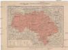
Politický okres Benešov
1 : 100000 Benešov-oblast (Česko) Kratochvíl, M. Josef Richard Vilímek
Politický okres Vlašim
1 : 100000 Vlašim-oblast (Česko) Kratochvíl, M. Josef Richard Vilímek
Politický okres Táborský
1 : 100000 Tábor-oblast (Česko) Srp, Jan Schwihlik, F. Jos. R. Vilímek
Okresní hejtmanství Sedlčanské

Situační mapka rudního terrainu v Sedlčanské vysočině
Benešov-oblast (Česko)
Selcan und Junc-Woschitz.
from Spezialkarte der osterreichisch-ungarischen Monarchie.
Politický okrec Benešovský
II. vojenské mapování 16
1 : 144000