Maps of Svojšín

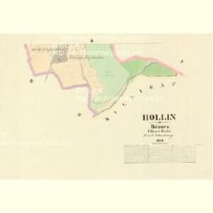
Hollin - c1981-1-002 - Kaiserpflichtexemplar der Landkarten des stabilen Katasters
1 : 2880
Hollin - c1981-1-001 - Kaiserpflichtexemplar der Landkarten des stabilen Katasters
1 : 2880
Gesürzen - c2878-1-001 - Kaiserpflichtexemplar der Landkarten des stabilen Katasters
1 : 2880
Gesürzen - c2878-1-002 - Kaiserpflichtexemplar der Landkarten des stabilen Katasters
1 : 2880
Millikau (Millikowo) - c4668-1-001 - Kaiserpflichtexemplar der Landkarten des stabilen Katasters
1 : 2880
Millikau (Millikowo) - c4668-1-003 - Kaiserpflichtexemplar der Landkarten des stabilen Katasters
1 : 2880
Millikau (Millikowo) - c4668-1-002 - Kaiserpflichtexemplar der Landkarten des stabilen Katasters
1 : 2880
Lohm - c4211-1-001 - Kaiserpflichtexemplar der Landkarten des stabilen Katasters
1 : 2880
Lohm - c4211-1-002 - Kaiserpflichtexemplar der Landkarten des stabilen Katasters
1 : 2880
Lohm - c4211-1-003 - Kaiserpflichtexemplar der Landkarten des stabilen Katasters
1 : 2880
Lohm - c4211-1-004 - Kaiserpflichtexemplar der Landkarten des stabilen Katasters
1 : 2880
Lingau - c5336-1-001 - Kaiserpflichtexemplar der Landkarten des stabilen Katasters
1 : 2880
Přehledová mapa velkostatku Kladruby
1 : 52300


Mieser Vicariat
Stříbro-oblast (Česko)
Stříbro a okolí
1 : 75000 Stříbro (Česko : oblast) Vojenský zeměpisný ústav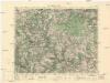
Město Teplá
1 : 75000 Teplá (Cheb, Česko : oblast) Vojenský zeměpisný ústav
Město Teplá
1 : 75000 Teplá-oblast (Cheb, Česko) Vojenský zeměpisný ústav
Tepl und Tuschkau
1 : 75000 Město Touškov (Česko : oblast) Bloschitz, Rudolf K. u. k. Militärgeographisches Institut
Tepl und Tuschkau
1 : 75000 Město Touškov-oblast (Česko) K. u. k. Militärgeographisches Institut
Podrobná mapa Království českého
1 : 100000 Planá (Tachov, Česko : oblast) Srp, Jan Jaroslav Bursík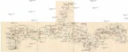
Böhmerwald-Verbindungsbahn
1 : 75000 Domažlice-Planá u Mariánských Lázní (Česko : železniční trať) Technisches Bureau Ing. Max Picha
Vilímkovy místopisné mapy zemí Koruny české
1 : 100000 Chodová Planá (Česko : oblast) Srp, Jan Jos. R. Vilímek
Tepl und Tuschkau.
from Spezialkarte der osterreichisch-ungarischen Monarchie.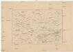
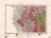
[Okolí Plzně - západ]
Plzeň-oblast (Česko) Krejčí, Jan Schwarzenberg, Bedřich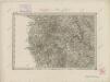
II. vojenské mapování 17
1 : 144000
Bischofteinitz und Nurschan.
from Spezialkarte der osterreichisch-ungarischen Monarchie.
Pfraumberg.
from Spezialkarte der osterreichisch-ungarischen Monarchie.