Maps of Ďáblice

Dablitz - c1643-1-003 - Kaiserpflichtexemplar der Landkarten des stabilen Katasters
1 : 2880
Dablitz - c1643-1-002 - Kaiserpflichtexemplar der Landkarten des stabilen Katasters
1 : 2880
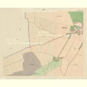
Dablitz - c1643-1-004 - Kaiserpflichtexemplar der Landkarten des stabilen Katasters
1 : 2880
Dablitz - c1643-1-005 - Kaiserpflichtexemplar der Landkarten des stabilen Katasters
1 : 2880
Dablitz - c1643-1-001 - Kaiserpflichtexemplar der Landkarten des stabilen Katasters
1 : 2880
Orientační plán Prahy a obcí sousedních List 2a.

Unter Chaber - c1293-1-003 - Kaiserpflichtexemplar der Landkarten des stabilen Katasters
1 : 2880
Unter Chaber - c1293-1-002 - Kaiserpflichtexemplar der Landkarten des stabilen Katasters
1 : 2880
Unter Chaber - c1293-1-001 - Kaiserpflichtexemplar der Landkarten des stabilen Katasters
1 : 2880
Výškopisný plán hlavního města Prahy s okolím

Orientační plán hlavního města Prahy s okolím

Orientační plán hlavního města Prahy s okolím
1 : 5000
Orientační plán hlavního města Prahy s okolím

Lettnian - c3894-1-004 - Kaiserpflichtexemplar der Landkarten des stabilen Katasters
1 : 2880
Lettnian - c3894-1-001 - Kaiserpflichtexemplar der Landkarten des stabilen Katasters
1 : 2880
Lettnian - c3894-1-003 - Kaiserpflichtexemplar der Landkarten des stabilen Katasters
1 : 2880
Lettnian - c3894-1-002 - Kaiserpflichtexemplar der Landkarten des stabilen Katasters
1 : 2880
Strzischkow - c7488-1-002 - Kaiserpflichtexemplar der Landkarten des stabilen Katasters
1 : 2880
Strzischkow - c7488-1-001 - Kaiserpflichtexemplar der Landkarten des stabilen Katasters
1 : 2880
Czakowitz - c0787-1-003 - Kaiserpflichtexemplar der Landkarten des stabilen Katasters
1 : 2880
Czakowitz - c0787-1-002 - Kaiserpflichtexemplar der Landkarten des stabilen Katasters
1 : 2880
Czakowitz - c0787-1-001 - Kaiserpflichtexemplar der Landkarten des stabilen Katasters
1 : 2880
Orientační plán hlavního města Prahy s okolím
1 : 5000
Orientační plán hlavního města Prahy s okolím

Bez titulu: Umgebungen von Prag

Projectierte Lager
1 : 15000 Brandýs nad Labem (Česko)
Výškopisný plán hlavního města Prahy s okolím

Výškopisný plán hlavního města Prahy s okolím
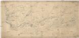
Les environs de Prague
1 : 31000 Praha (Česko)