Maps of Liběšice

Dubschan - c1582-1-001 - Kaiserpflichtexemplar der Landkarten des stabilen Katasters
1 : 2880
Dubschan - c1582-1-002 - Kaiserpflichtexemplar der Landkarten des stabilen Katasters
1 : 2880
Drahomischl - c1493-1-003 - Kaiserpflichtexemplar der Landkarten des stabilen Katasters
1 : 2880
Drahomischl - c1493-1-001 - Kaiserpflichtexemplar der Landkarten des stabilen Katasters
1 : 2880
Drahomischl - c1493-1-002 - Kaiserpflichtexemplar der Landkarten des stabilen Katasters
1 : 2880
Liebeschitz - c4003-1-001 - Kaiserpflichtexemplar der Landkarten des stabilen Katasters
1 : 2880
Liebeschitz - c4003-1-003 - Kaiserpflichtexemplar der Landkarten des stabilen Katasters
1 : 2880
Liebeschitz - c4003-1-002 - Kaiserpflichtexemplar der Landkarten des stabilen Katasters
1 : 2880
Liebeschitz - c4003-1-004 - Kaiserpflichtexemplar der Landkarten des stabilen Katasters
1 : 2880
Tuchořzitz (Tuchořic) - c8102-1-003 - Kaiserpflichtexemplar der Landkarten des stabilen Katasters
1 : 2880
Tuchořzitz (Tuchořic) - c8102-1-005 - Kaiserpflichtexemplar der Landkarten des stabilen Katasters
1 : 2880
Tuchořzitz (Tuchořic) - c8102-1-004 - Kaiserpflichtexemplar der Landkarten des stabilen Katasters
1 : 2880
Tuchořzitz (Tuchořic) - c8102-1-002 - Kaiserpflichtexemplar der Landkarten des stabilen Katasters
1 : 2880
Tuchořzitz (Tuchořic) - c8102-1-006 - Kaiserpflichtexemplar der Landkarten des stabilen Katasters
1 : 2880
Tuchořzitz (Tuchořic) - c8102-1-001 - Kaiserpflichtexemplar der Landkarten des stabilen Katasters
1 : 2880
Karte des Bezirkes Postelberg
1 : 36000 Postoloprty-oblast (Česko) Hollmann, Victor Josef Mecséry de Tsóor, Karl Johann Friedrich Selner
[Kartenblatt]
1 : 25000 Louny (Česko : oblast) Reichsamt für Landesaufnahme
III. vojenské mapování 3851/4
1 : 25000
Gradkartenblatt
1 : 25000 Postoloprty-oblast (Česko) Bellschan, Anton
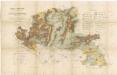
Terénní a půdní mapa pro exkurzi Českého lesnického spolku do domoušického lesního okrsku v roce 1881 1
1 : 30000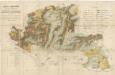
Terénní a půdní mapa pro exkurzi Českého lesnického spolku do domoušického lesního okrsku v roce 1881 1
1 : 30000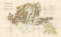
Terénní a půdní mapa pro exkurzi Českého lesnického spolku do domoušického lesního okrsku v roce 1881 1
1 : 30000
Přehledná mapa rozptýlených lesů mezi polnostmi lesního úřadu Domoušice 1
1 : 34560
Chomutov
1 : 75000 Chomutov-oblast (Česko) Vojenský zeměpisný ústav
Chomutov
1 : 75000 Chomutov (Česko : oblast) Vojenský zeměpisný ústav
Saaz und Komotau
1 : 75000 Chomutov (Česko : oblast) Fitz, J. K. u. k. militär-geographisches Institut
Saaz und Komotau
1 : 75000 Chomutov (Česko : oblast) Fitz, J. K. u. k. Militärgeographisches Institut
Saaz und Komotau
1 : 75000 Chomutov (Česko : oblast) K. u. k. Militärgeographisches Institut


