Maps of Chotyně

Döhnis - c1443-1-001 - Kaiserpflichtexemplar der Landkarten des stabilen Katasters
1 : 2880
Döhnis - c1443-1-002 - Kaiserpflichtexemplar der Landkarten des stabilen Katasters
1 : 2880
Döhnis - c1443-1-003 - Kaiserpflichtexemplar der Landkarten des stabilen Katasters
1 : 2880
Görsdorf - c4242-3-001 - Kaiserpflichtexemplar der Landkarten des stabilen Katasters
1 : 2880
Görsdorf - c4242-3-002 - Kaiserpflichtexemplar der Landkarten des stabilen Katasters
1 : 2880
Görsdorf - c4242-3-003 - Kaiserpflichtexemplar der Landkarten des stabilen Katasters
1 : 2880
Spittelgrund - c1382-2-004 - Kaiserpflichtexemplar der Landkarten des stabilen Katasters
1 : 2880
Spittelgrund - c1382-2-002 - Kaiserpflichtexemplar der Landkarten des stabilen Katasters
1 : 2880
Spittelgrund - c1382-2-003 - Kaiserpflichtexemplar der Landkarten des stabilen Katasters
1 : 2880
Spittelgrund - c1382-2-001 - Kaiserpflichtexemplar der Landkarten des stabilen Katasters
1 : 2880
Spittelgrund - c1382-2-005 - Kaiserpflichtexemplar der Landkarten des stabilen Katasters
1 : 2880
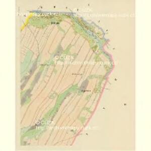
Ketten - c2611-1-003 - Kaiserpflichtexemplar der Landkarten des stabilen Katasters
1 : 2880
Ketten - c2611-1-002 - Kaiserpflichtexemplar der Landkarten des stabilen Katasters
1 : 2880
Ketten - c2611-1-001 - Kaiserpflichtexemplar der Landkarten des stabilen Katasters
1 : 2880
Ketten - c2611-1-004 - Kaiserpflichtexemplar der Landkarten des stabilen Katasters
1 : 2880
Grottau - c2300-1-004 - Kaiserpflichtexemplar der Landkarten des stabilen Katasters
1 : 2880
Grottau - c2300-1-002 - Kaiserpflichtexemplar der Landkarten des stabilen Katasters
1 : 2880
Grottau - c2300-1-005 - Kaiserpflichtexemplar der Landkarten des stabilen Katasters
1 : 2880
Grottau - c2300-1-003 - Kaiserpflichtexemplar der Landkarten des stabilen Katasters
1 : 2880
Grottau - c2300-1-001 - Kaiserpflichtexemplar der Landkarten des stabilen Katasters
1 : 2880
Nieder Berzdorf - c1394-1-003 - Kaiserpflichtexemplar der Landkarten des stabilen Katasters
1 : 2880
Nieder Berzdorf - c1394-1-001 - Kaiserpflichtexemplar der Landkarten des stabilen Katasters
1 : 2880
Nieder Berzdorf - c1394-1-002 - Kaiserpflichtexemplar der Landkarten des stabilen Katasters
1 : 2880
[Kartenblatt]
1 : 25000 Chrastava (Liberec, Česko : oblast) Reichsamt für Landesaufnahme
Das böhmisch-sächsische Grenzgebirge
Lužická Nisa-oblast lith. Kunstanstalt von Ed. Strache
Reichenberg u. Friedland
1 : 75000 Frýdlant (Česko : oblast) Reichenauer K. u. k. Militärgeographisches Institut
Reichenberg u. Friedland
1 : 75000 Frýdlant (Česko : oblast) Reichenauer K. u. k. Militärgeographisches Institut
Reichenberg u[nd] Friedland
1 : 75000 Frýdlant (Česko : oblast) K. u. k. Militärgeographisches Institut