Maps of Nemyšl

Didiz - c1098-1-002 - Kaiserpflichtexemplar der Landkarten des stabilen Katasters
1 : 2880
Didiz - c1098-1-001 - Kaiserpflichtexemplar der Landkarten des stabilen Katasters
1 : 2880
Nemischel - c5033-1-001 - Kaiserpflichtexemplar der Landkarten des stabilen Katasters
1 : 2880
Nemischel - c5033-1-002 - Kaiserpflichtexemplar der Landkarten des stabilen Katasters
1 : 2880
Nemischel - c5033-1-004 - Kaiserpflichtexemplar der Landkarten des stabilen Katasters
1 : 2880
Nemischel - c5033-1-003 - Kaiserpflichtexemplar der Landkarten des stabilen Katasters
1 : 2880
Raschowitz - c6446-1-003 - Kaiserpflichtexemplar der Landkarten des stabilen Katasters
1 : 2880
Raschowitz - c6446-1-001 - Kaiserpflichtexemplar der Landkarten des stabilen Katasters
1 : 2880
Raschowitz - c6446-1-002 - Kaiserpflichtexemplar der Landkarten des stabilen Katasters
1 : 2880
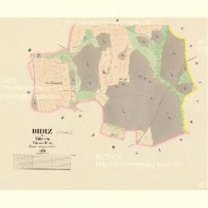
Gedlan - c2806-1-001 - Kaiserpflichtexemplar der Landkarten des stabilen Katasters
1 : 2880
Gedlan - c2806-1-002 - Kaiserpflichtexemplar der Landkarten des stabilen Katasters
1 : 2880
Gedlan - c2806-1-003 - Kaiserpflichtexemplar der Landkarten des stabilen Katasters
1 : 2880
Muttitz - c4908-1-002 - Kaiserpflichtexemplar der Landkarten des stabilen Katasters
1 : 2880
Muttitz - c4908-1-001 - Kaiserpflichtexemplar der Landkarten des stabilen Katasters
1 : 2880


Polohopisná mapa silnic, cest a obecního majetku Táborského
[Tábor a okolí]
Soběslav (Česko)
Podrobné mapy zemí Koruny české v měřítku 1:75.000 a mapa vzdáleností všech míst při silnici ležících - Tábor - Milevsko - Sedlec. Průvodce statisticko-historický po všech místech na těchto mapách uvedených a rejstřík věcný názvů hor, potoků, řek, rybníků atd. Sešit 44. List 58,
1 : 75000
Podrobné mapy zemí Koruny české v měřítku 1:75.000 a mapy vzdáleností všech míst při silnici ležících
1 : 75000 Milevsko (Česko : oblast) Bělohlav, Josef F. Topič
Polohopisná mapa silnic, cest a obecního majetku Táborského

Mapa okolí Tábora
1 : 76000 Tábor-oblast (Česko) Hemmr, Jan Václav Kraus
Sedlčany
1 : 75000 Sedlčany (Česko : oblast) Vojenský zeměpisný ústav
Sedlčany
1 : 75000 Sedlčany (Česko : oblast) Vojenský zeměpisný ústav
Selčan und Jung-Woschitz
1 : 75000 Mladá Vožice (Česko : oblast) Hertel, A. K. u. k. Militärgeographisches Institut
Selčan und Jung-Woschitz
1 : 75000 Mladá Vožice (Česko : oblast) K. u. k. Militärgeographisches Institut
Vilímkovy místopisné mapy zemí Koruny české
1 : 100000 Milevsko (Česko : oblast) Srp, Jan Jos. R. Vilímek
Podrobná mapa Království českého
1 : 100000 Milevsko (Česko : oblast) Srp, Jan Jaroslav Bursík
Politický okres Táborský
1 : 100000 Tábor-oblast (Česko) Srp, Jan Schwihlik, F. Jos. R. Vilímek