Maps of Divišov

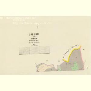
Dallow - c1057-1-001 - Kaiserpflichtexemplar der Landkarten des stabilen Katasters
1 : 2880
Dallow - c1057-1-002 - Kaiserpflichtexemplar der Landkarten des stabilen Katasters
1 : 2880
Křeschitz - c3637-1-001 - Kaiserpflichtexemplar der Landkarten des stabilen Katasters
1 : 2880
Křeschitz - c3637-1-002 - Kaiserpflichtexemplar der Landkarten des stabilen Katasters
1 : 2880
Mappa zum Sternhoff gehörige Wälder

Diwischau (Diwišow) - c1123-1-002 - Kaiserpflichtexemplar der Landkarten des stabilen Katasters
1 : 2880
Diwischau (Diwišow) - c1123-1-001 - Kaiserpflichtexemplar der Landkarten des stabilen Katasters
1 : 2880
Diwischau (Diwišow) - c1123-1-005 - Kaiserpflichtexemplar der Landkarten des stabilen Katasters
1 : 2880
Diwischau (Diwišow) - c1123-1-003 - Kaiserpflichtexemplar der Landkarten des stabilen Katasters
1 : 2880
Diwischau (Diwišow) - c1123-1-004 - Kaiserpflichtexemplar der Landkarten des stabilen Katasters
1 : 2880
Diwischau (Diwišow) - c1123-1-006 - Kaiserpflichtexemplar der Landkarten des stabilen Katasters
1 : 2880
Lbosin - c3837-1-002 - Kaiserpflichtexemplar der Landkarten des stabilen Katasters
1 : 2880
Lbosin - c3837-1-003 - Kaiserpflichtexemplar der Landkarten des stabilen Katasters
1 : 2880
Lbosin - c3837-1-001 - Kaiserpflichtexemplar der Landkarten des stabilen Katasters
1 : 2880

III. vojenské mapování 4054/3
1 : 25000
III. vojenské mapování 4054/3
1 : 25000
Gradkartenblatt
1 : 25000 Čechy (Česko) Czechák, Carl
Kutná Hora
1 : 75000 Kutná Hora (Česko : oblast) Vojenský zeměpisný ústav
Kuttenberg und Kohljanowitz
1 : 75000 Kutná Hora (Česko : oblast) Kotrtsch K. u. k. militär-geographisches Institut
Kuttenberg und Kohljanowitz
1 : 75000 Kutná Hora (Česko : oblast) Kotrtsch K. u. k. Militärgeographisches Institut
Kuttenberg und Kohljanowitz
1 : 75000 Kutná Hora (Česko : oblast) K. u. k. Militärgeographisches Institut
Mapy plánování ČSR

Bystřický vikariát
Bystřice (Benešov, Česko)
III. vojenské mapování 4054
1 : 75000
Karte des Gemeindegrenzen

Podrobná mapa Království českého
1 : 100000 Ledeč nad Sázavou (Česko : oblast) Srp, Jan Jaroslav Bursík
[Vilímkovy místopisné mapy zemí Koruny české]
1 : 100000 Ledeč nad Sázavou (Česko : oblast) Srp, Jan Jos. R. Vilímek
Politický okres Benešov
1 : 100000 Benešov-oblast (Česko) Kratochvíl, M. Josef Richard Vilímek