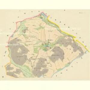
Maps of Svatý Jan

Brazna - c0491-1-001 - Kaiserpflichtexemplar der Landkarten des stabilen Katasters
1 : 2880
Brazna - c0491-1-002 - Kaiserpflichtexemplar der Landkarten des stabilen Katasters
1 : 2880
Tisownitz - c7922-1-002 - Kaiserpflichtexemplar der Landkarten des stabilen Katasters
1 : 2880
Tisownitz - c7922-1-001 - Kaiserpflichtexemplar der Landkarten des stabilen Katasters
1 : 2880
Skregschow (Skregssow) - c6963-1-003 - Kaiserpflichtexemplar der Landkarten des stabilen Katasters
1 : 2880
Skregschow (Skregssow) - c6963-1-001 - Kaiserpflichtexemplar der Landkarten des stabilen Katasters
1 : 2880
Skregschow (Skregssow) - c6963-1-002 - Kaiserpflichtexemplar der Landkarten des stabilen Katasters
1 : 2880
Draschkow - c1521-1-003 - Kaiserpflichtexemplar der Landkarten des stabilen Katasters
1 : 2880
Draschkow - c1521-1-002 - Kaiserpflichtexemplar der Landkarten des stabilen Katasters
1 : 2880
Draschkow - c1521-1-004 - Kaiserpflichtexemplar der Landkarten des stabilen Katasters
1 : 2880
Draschkow - c1521-1-001 - Kaiserpflichtexemplar der Landkarten des stabilen Katasters
1 : 2880
Schönberg (Krasna Hora) - c3517-1-004 - Kaiserpflichtexemplar der Landkarten des stabilen Katasters
1 : 2880
Schönberg (Krasna Hora) - c3517-1-001 - Kaiserpflichtexemplar der Landkarten des stabilen Katasters
1 : 2880
Schönberg (Krasna Hora) - c3517-1-002 - Kaiserpflichtexemplar der Landkarten des stabilen Katasters
1 : 2880
Schönberg (Krasna Hora) - c3517-1-005 - Kaiserpflichtexemplar der Landkarten des stabilen Katasters
1 : 2880
Schönberg (Krasna Hora) - c3517-1-003 - Kaiserpflichtexemplar der Landkarten des stabilen Katasters
1 : 2880
Mapy plánování ČSR

Podrobné mapy zemí Koruny české v měřítku 1:75.000 a mapa vzdáleností všech míst při silnici ležících - Příbram - Dobříš. Průvodce statisticko-historický po všech místech na těchto mapách uvedených a rejstřík věcný názvů hor, potoků, řek, rybníků atd./ Sešit 10. List 43,
1 : 75000
Wotický vikariát
Votice-oblast (Česko)
Podrobné mapy zemí Koruny české v měřítku 1:75.000 a mapa vzdáleností všech míst při silnici ležících
1 : 75000 Dobříš (Česko : oblast) Bělohlav, Josef F. Topič
Přibram und Mirowitz
1 : 75000 Mirovice (Česko : oblast) Schill K. u. k. Militärgeographisches Institut
Přibram und Mirowitz
1 : 75000 Mirovice (Česko : oblast) K. u. k. Militärgeographisches Institut
Přehledná mapa velkostatku Orlíka, Čimelic a Varvažova s vyznačením hranic jednotlivých katastrálních obcí a pozemkové držby velkostatku s označením jednotlivých parcel 1

III. vojenské mapování 4152
1 : 75000
Mapy plánování ČSR

Příbram
1 : 75000 Příbram (Česko : oblast) Vojenský zeměpisný ústav
Příbram
1 : 75000 Příbram-oblast (Česko) Vojenský zeměpisný ústav
Příbram
1 : 75000 Příbram (Česko : oblast) Vojenský zeměpisný ústav