Maps of Chvaleč

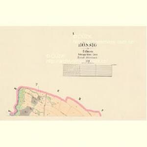
Bössig - c0158-1-001 - Kaiserpflichtexemplar der Landkarten des stabilen Katasters
1 : 2880
Bössig - c0158-1-002 - Kaiserpflichtexemplar der Landkarten des stabilen Katasters
1 : 2880
Wellhotta (Lhotta) - c3929-1-001 - Kaiserpflichtexemplar der Landkarten des stabilen Katasters
1 : 2880
Wellhotta (Lhotta) - c3929-1-002 - Kaiserpflichtexemplar der Landkarten des stabilen Katasters
1 : 2880
Petersdorf (Petrowice) - c5745-1-004 - Kaiserpflichtexemplar der Landkarten des stabilen Katasters
1 : 2880
Petersdorf (Petrowice) - c5745-1-002 - Kaiserpflichtexemplar der Landkarten des stabilen Katasters
1 : 2880
Petersdorf (Petrowice) - c5745-1-001 - Kaiserpflichtexemplar der Landkarten des stabilen Katasters
1 : 2880
Petersdorf (Petrowice) - c5745-1-003 - Kaiserpflichtexemplar der Landkarten des stabilen Katasters
1 : 2880
Markausch (Markauschowitz) - c4480-1-004 - Kaiserpflichtexemplar der Landkarten des stabilen Katasters
1 : 2880
Markausch (Markauschowitz) - c4480-1-002 - Kaiserpflichtexemplar der Landkarten des stabilen Katasters
1 : 2880
Markausch (Markauschowitz) - c4480-1-003 - Kaiserpflichtexemplar der Landkarten des stabilen Katasters
1 : 2880
Markausch (Markauschowitz) - c4480-1-001 - Kaiserpflichtexemplar der Landkarten des stabilen Katasters
1 : 2880
[Trautenau und Umgebung]
1 : 25000 Trutnov (Česko : oblast)
Plan des Gefechtsfeldes von Trautenau am 27 Juni 1866 und des Gefechtsfeldes von Soor am 28 Juni 1866
1 : 25000 Trutnov-oblast (Česko) Schmeling, von
Plan des Gefechtsfeldes von Trautenau am 27 Juni 1866 und des Gefechtsfeldes von Soor am 28 Juni 1866
1 : 25000 Trutnov-oblast (Česko) Schmeling, von
III. vojenské mapování 3756
1 : 75000
III. vojenské mapování 3756/3
1 : 25000
[Kartenblatt]
1 : 25000 Mladé Buky (Česko : oblast) Reichsamt für Landesaufnahme
Bez titulu: Soubor plánů – Prusko-Rakouská válka 1866

Geologická mapa žacléřsko-svatoňovicko-žďáreckého uhelného revíru
1 : 75000 Žacléř-oblast (Česko) Sandtner, Boh. Hornicko-hutnické nakladatelství Prometheus

Broumov-Úpice
1 : 74000 Broumov (Náchod, Česko : oblast) Weber-Ostwalden
Plan des glückl. Treffens Sr. Königl. Maj. in Preussen den 30ten Sept. 1745 bey Sahr in Böhmen, Königin Graetzer Creÿss der Gegend Trautenau in einer accuraten Charte selbigen Terrains
1 : 110000 Mollova mapová sbírka Werner, Bedřich Bernard
Neueste Wegekarte vom Riesengebirge und Situationsplan von Johannsbad
1 : 75000 Janské Lázně (Česko : oblast) Vatter, Alfred Alfred Vatter
Gegend zwischen Schatzlar Golden-Else und Wekelsdorf
Žacléř-oblast (Česko)
Vilímkovy místopisné mapy zemí Koruny české
1 : 100000 Broumov (Náchod, Česko : oblast) Srp, Jan Jos. R. Vilímek
Topographische und Militairische Carte desienigen Theils von Boehmen...

Úpice a okolí

Trutnov
1 : 75000 Trutnov (Česko : oblast) Vojenský zeměpisný ústav
Trutnov
1 : 75000 Trutnov-oblast (Česko) Vojenský zeměpisný ústav