Maps of Regierungsbezirk Düsseldorf

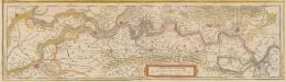
Ducatus Iuliacensis, Cliviensis et Montensis, ut et principatus Meursiani et comitatus Zutphaniensis
1 : 370000 Jülich (Německo) Seutter, Matthäus opera et impensis Matthaei Seutteri
[Kaart], uit: Sleeswijk's kaart van Limburg : naar officieële gegevens bewerkt voor wandelaars, wielrijders en automobilisten, voor school, kantoor en huiskamer : met nauwkeurige afstandsbepalingen in kilometers tusschen de plaatsen
1 : 150000 titelvariant: Limburg; Annotatie: Omslagtitel; Tweede titel boven de kaart: Limburg; In verso: plaatsnamenregister; Annotatie geografische gegevens: Schaalstok; Legenda J.A. Sleeswijk, Bussum; J. Smulders & Co., 's-Gravenhage Bussum : J.A. Sleeswijk / (Lith. J. Smulders & Co., Den Haag)
Ducatus Gelriae pars secunda quae est Ruremondensis / [Joannes Janssonius]
1 : 300000 Annotatie: Het eerst verschenen in: Des nieuwen Atlantis aenhang ... derde deel ... - Amstelodami : apud Ioannem Ianssonium, 1644; Origineel is Blad 67 in atlas factice; Annotatie geografische gegevens: Zuidoost boven Janssonius, Joannes (jr.) (1588-1664) [Amsterdam : Joannes Janssonius]
[98][99] Tetrachia Ducatus Geldriae Ruremondana sive Hispanica, uit: Atlas sive Descriptio terrarum orbis
Annotatie: Gedigitaliseerde versie. Amsterdam. Heiloo : Picturae (vervaardiger), 2015. tiff-bestand. Gedigitaliseerd: 07-01-2015; Origineel: Universiteitsbibliotheek Vrije Universiteit (XL.05127.-) ; Netherlands; Titelpagina ontbreekt Wit, Frederik de Amsterdam : Frederick de Wit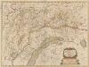
Ducatus Gelriae pars secunda Quae est Ruremondensis. [Karte], in: Novus atlas absolutissimus, Bd. 3, S. 88.
1 Karte aus Atlas Janssonius Offizin
Limburg, uit: Sterfte-atlas van Nederland over 1860-1874 / [uitgave van de Nederlandsche Maatschappij tot Bevordering der Geneeskunst]
titelvariant: Sterfte-atlas van Nederland; Annotatie: Alleen kaartbijlage aanwezig Pieter Harmen Witkamp 1816-1892; Nederlandsche Maatschappij tot Bevordering der Geneeskunst Amsterdam : van Rossen
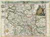
TETRARCHIA | Ducatus Gelriæ | RVRÆMVNDENSIS
[Amsterdam : Joan Blaeu]
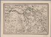
Clivia Dvcatvs et Ravestein Dominivm
1 : 230000 Mollova mapová sbírka Schenk, Pieter Schenk, Peter I
Gueldre Espagnole, ou Quartier de Ruremonde dans le Duché de Gueldre
1 : 210000 Mollova mapová sbírka Sanson, Guillaume Jaillot, Alexis Hubert
Ruermond het over vierdeel van Gelderlandt
1 : 250000 [Nicolaas van Geelkercken] [S.l.] : [s.n.]
Le Duché de Luxembourg divisé en Quartier Walon, et Allemand
1 : 140000 Mollova mapová sbírka Jaillot, Alexis-Hubert Jaillot, Alexis Hubert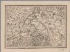
[19], uit: Hydro-Oro und Chorographische General Karte des Koenigreichs der Niederlande und der angrenzenden Länder bis Paris : mit der Angabe der Kunst und Heer-Strassen und der Entfernung der Poststationen / ... zusammengetragen und reducirt von ... Wilhelm Müller
1 : 400000 titelvariant: Generalkarte des Koenigreichs Hannover; Annotatie: 1e supplement bij: Generalkarte des Koenigreichs Hannover (1818) Müller, Wilhelm (fl. 1818) [Hannover : Wilhelm Müller]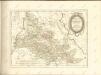
Le Duché de Cleves avec des Seigneries confinantes
1 : 700000 Mollova mapová sbírka Baeck, Elias Bäck, Elias
Gueldre Espagnole, ou Quartier de Ruremonde dans le duché de Gueldre avec ses enclaves dans les pays circomvoisins
1 : 200000 dressé sur les memoires les plus nouveaux par le S.r Sanson, geographe ordinaire du Roy. A Paris : chez H. Jaillot, joignant les grands Augustins, aux deux globes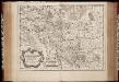
Le duché de Clèves, la seigneurie de Ravenstein, et le comté de Meurs / tirée des mémoirs les plus recents par le Sr. Sanson
1 : 200000 Annotatie: Origineel is Blad 65 in atlas factice Guillaume Sanson 1633-1703 A Paris : chez H. Iaillot
Kaart van het hertogdom Limburg
1 : 75000 vervaardigd met goedkeuring der Provinciale Staten volgens de uitkomsten van het kadaster door J.F. Bonniver ... geteekend door J.F.M. Bonniver zoon ; gegraveerd door L. Muller ... [S.l.] : [s.n.]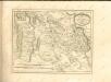
[15], uit: Hydro-Oro und Chorographische General Karte des Koenigreichs der Niederlande und der angrenzenden Länder bis Paris : mit der Angabe der Kunst und Heer-Strassen und der Entfernung der Poststationen / ... zusammengetragen und reducirt von ... Wilhelm Müller
1 : 400000 titelvariant: Generalkarte des Koenigreichs Hannover; Annotatie: 1e supplement bij: Generalkarte des Koenigreichs Hannover (1818) Müller, Wilhelm (fl. 1818) [Hannover : Wilhelm Müller]
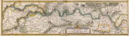
Tractus Rheni et Mosae totusque Vahalis à Rhenoberca Gorcomium usque cum terris adiacentibus [...] [Karte, Teil 2], in: Theatrum orbis terrarum, sive, Atlas novus, Bd. 1, S. 416.
1 Karte aus Atlas Blaeu, Joan Blaeu, Willem Janszoon
Le Duché de Cleves; la Seigneurie de Ravenstein, et le Comté de Meurs.
1 : 240000 Mollova mapová sbírka Sanson, Guillaume Jaillot, Alexis Hubert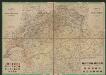
Descriptio Fluminum Rheni, Vahalis et Mosae a Rheno Berca ad Goricominum [...] [Karte, Teil 2], in: Gerardi Mercatoris et I. Hondii Newer Atlas, oder, Grosses Weltbuch, Bd. 1, S. 410.
1 Karte aus Atlas Mercator, Gerhard und Hondius, Jodocus Jansson, Jan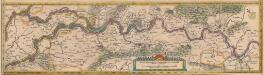
Tractus Rheni et Mosae, totusque Vahalis à Rhenoberca Gorcomium usque cum terris adjacentibus [...] [Karte, Teil 2], in: Novus Atlas, das ist, Weltbeschreibung, Bd. 1, S. 382.
1 Karte aus Atlas Blaeu, Joan Blaeu, Willem Janszoon
Clivia Ducatus Et Ravestein Dominium. [Karte], in: Novus atlas absolutissimus, Bd. 2, S. 130.
1 Karte aus Atlas Janssonius Offizin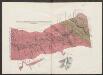
Clivia Ducatus Et Ravestein Dominium. [Karte], in: Le théâtre du monde, ou, Nouvel atlas contenant les chartes et descriptions de tous les païs de la terre, Bd. 1, S. 314.
1 Karte aus Atlas Blaeu, Willem Janszoon und Blaeu, Joan Blaeu, Willem Janszoon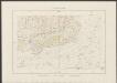
Clivia Ducatus Et Ravestein Dominium. [Karte], in: Theatrum orbis terrarum, sive, Atlas novus, Bd. 1, S. 224.
1 Karte aus Atlas Blaeu, Joan Blaeu, Willem Janszoon
Clivia Ducatus Et Ravestein Dominium. [Karte], in: Novus Atlas, das ist, Weltbeschreibung, Bd. 1, S. 285.
1 Karte aus Atlas Blaeu, Joan Blaeu, Willem Janszoon
Tractus Rheni et Mosae, totusque Vahalis à Rhenoberca Gorcomium usque cum terris adiacentibus [...] [Karte, Teil 2], in: Le théâtre du monde, ou, Nouvel atlas contenant les chartes et descriptions de tous les païs de la terre, Bd. 1, S. 411.
1 Karte aus Atlas Blaeu, Willem Janszoon und Blaeu, Joan Blaeu, Willem Janszoon