Maps of Hradčany
Stadt Strahov
Strahov (Praha, Česko)
Polohopisný plán královského hlavního města Prahy : 1.Staré město, 2.Nové město, 3.Malá strana, 4.Hradčany, 5.Josefov, 6.Vyšehrad pak Smíchova, Karlína, král.Vinohradů, Žižkova a Nuslí, s udáním starých i nových čísel domů
1 : 4000
Plán hlavního města království českého Praha

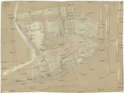
Střeschowitz (Střessowic) - c7457-1-001 - Kaiserpflichtexemplar der Landkarten des stabilen Katasters
1 : 2880
Střeschowitz (Střessowic) - c7457-1-002 - Kaiserpflichtexemplar der Landkarten des stabilen Katasters
1 : 2880
Orientační plán Prahy a obcí sousedních List 10.
1 : 5000
Orientační plán Prahy a obcí sousedních List 10.
Polohopisný plán Malé Strany a Hradčan
1 : 4000 Hradčany (Praha, Česko) Hurtig, Alfred F. Kytka
Orientační plán hlavního města Prahy s okolím
1 : 5000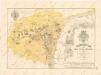
Polohopisný plán Malé Strany a Hradčan

Polohopisný plán Malé Strany a Hradčan
1 : 4000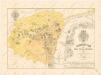
Polohopisný plán Malé Strany a Hradčan

Mapový obraz Malé Strany a Strahova ze 17. století : [faksimile plánů]

Grundrisz der königlichen Hauptstadt Prag
Praha (Česko) Jüttner, Josef Drda, Josef Jan Alois auf Veranlassung und Kosten des böhmischen Nationalmuseums
Monumentální plán královského města Prahy

Výškopisný plán hlavního města Prahy s okolím

Kriegs-Expedit. Karte in Böhmen III Blat in welcher die Belagerung Prag A. 1742 von den 28. Iul. bis 13. 7br. zuversichtlich vorgestellet wird
Malá Strana (Praha, Česko) Sinsart Perizot von Homaenn. Erben
Polohopisný plán Prahy
Praha (Česko) K. Hübner
Grund-Rieß uber den Kossirz- und Czibulker Hoff auch Czisarzska
1 : 2500 Košíře (Praha, Česko) Mann, Johann Joseph Florian
Praha, hlavní město ČSR : Fastrův obrázkový plán a průvodce
1 : 10000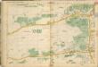
Auto-Praha : automobilní plán Velké Prahy a příručka pro automobilisty
1 : 50000
Praha. Mapy staré Prahy k letům 1200, 1348 a 1419

Eigentlicher Grundriß der Königlichen Statt Prag
Praha (Česko)
Plan von Prag

Grundriss von Prag, nach den besten Hülfsmitteln dargestellt
1 : 125000 gestochen von W. Schuldes Prag : J. G. Calve'sche Buchhandlung
Prag - c6068-1-002 - Kaiserpflichtexemplar der Landkarten des stabilen Katasters
1 : 2880
Prag - c6068-1-006 - Kaiserpflichtexemplar der Landkarten des stabilen Katasters
1 : 2880
Prag - c6068-1-003 - Kaiserpflichtexemplar der Landkarten des stabilen Katasters
1 : 2880
Prag - c6068-1-001 - Kaiserpflichtexemplar der Landkarten des stabilen Katasters
1 : 2880
Prag - c6068-1-004 - Kaiserpflichtexemplar der Landkarten des stabilen Katasters
1 : 2880